Login
Register


TMA
Henry Tift Myers Airport
Official FAA Data Effective 2025-12-25 0901Z
Chart Supplement

VFR Chart of KTMA
Sectional Charts at SkyVector.com
IFR Chart of KTMA
Enroute Charts at SkyVector.com
Location Information for KTMA
Coordinates: N31°25.77' / W83°29.35'Located 02 miles SE of Tifton, Georgia on 826 acres of land. View all Airports in Georgia.
Surveyed Elevation is 354 feet MSL.
Operations Data
|
|
Airport Communications
| AWOS-3PT: | 118.525 Tel. 229-386-8937 |
|---|---|
| VALDOSTA APPROACH: | 126.6 ;EAST OF VAD 360-VAD 180 132.375 ;WEST OF VAD R-360 RADIAL 285.6 ;EAST OF VAD 360-VAD 180 |
| VALDOSTA DEPARTURE: | 126.6 ;EAST OF VAD 360-VAD 180 132.375 ;WEST OF VAD R-360 RADIAL 285.6 ;EAST OF VAD 360-VAD 180 |
| IC: | 126.6 ;EAST OF VAD 360-VAD 180 285.6 ;EAST OF VAD 360-VAD 180 |
| UNICOM: | 122.700 |
| CTAF: | 122.700 |
| AWOS-3PT at 15J (17.6 S): | 118.025 229-896-4223 |
| AWOS-3PT at FZG (18.9 NE): | 118.625 229-426-5072 |
| AWOS-3PT at MGR (26.3 SW): | 118.925 229-890-5320 |
- APCH/DEP SVC PRVDD BY JACKSONVILLE ARTCC ON FREQS 133.7/323.3(VALDOSTA RCAG) WHEN VALDOSTA APCH CTL CLSD.
Nearby Navigation Aids
|
| ||||||||||||||||||||||||||||||||||||||||||||||||||||||||||||


Runway 16/34
| Dimensions: | 6506 x 100 feet / 1983 x 30 meters | |
|---|---|---|
| Surface: | Asphalt in Good Condition | |
| Weight Limits: | S-42, D-60, ST-106 | |
| Edge Lighting: | High Intensity | |
| Runway 16 | Runway 34 | |
| Coordinates: | N31°26.16' / W83°29.78' | N31°25.24' / W83°29.14' |
| Elevation: | 352.2 | 339.0 |
| Traffic Pattern: | Left | Left |
| Runway Heading: | 149° True | 329° True |
| Markings: | Precision Instrument in good condition. | Precision Instrument in good condition. |
| Glide Slope Indicator | P4L (3.00° Glide Path Angle) | P4L (3.00° Glide Path Angle) |
| Approach Lights: | MALSR 1,400 Foot Medium-intensity Approach Lighting System with runway alignment indicator lights. | |
| Obstacles: | 20 ft Pole 260 ft from runway, 400 ft right of center 40' TREE, 190' FROM E.O.R, 491' RIGHT, AND 30' POLE, 190' FROM E.O.R., 425' RIGHT. |
58 ft Trees 722 ft from runway, 549 ft left of center |
Runway 10/28
| Dimensions: | 3807 x 75 feet / 1160 x 23 meters | |
|---|---|---|
| Surface: | Asphalt in Good Condition | |
| Weight Limits: | S-30, D-45, ST-75 | |
| Runway 10 | Runway 28 | |
| Coordinates: | N31°25.92' / W83°29.53' | N31°25.87' / W83°28.80' |
| Elevation: | 350.7 | 338.7 |
| Traffic Pattern: | Left | Left |
| Runway Heading: | 94° True | 274° True |
| Markings: | Non-Precision Instrument in good condition. | Non-Precision Instrument in good condition. |
| Obstacles: | 93 ft Trees 1781 ft from runway, 1 ft left of center | |
Services Available
| Fuel: | 100LL (blue), Jet-A, Jet A+ |
|---|---|
| Transient Storage: | Tiedowns |
| Airframe Repair: | MAJOR |
| Engine Repair: | MAJOR |
| Bottled Oxygen: | NONE |
| Bulk Oxygen: | NONE |
| Other Services: | PILOT INSTRUCTION |
Ownership Information
| Ownership: | Publicly owned | |
|---|---|---|
| Owner: | TIFTON & TIFT CO ARPT AUTH. | |
| PO BOX 826 | ||
| TIFTON, GA 31793 | ||
| 229-391-3535 | ||
| Manager: | ERIC RICHTER | |
| 3093 US HIGHWAY 41 S | ||
| TIFTON, GA 31794 | ||
| 229-425-1791 | ||
Other Remarks
- (E99) USED FOR MAINT.
- (CONTACT TITLE) CHAIRMAN HENRY TIFT MYERS AIRPORT AUTHORITY.
- 0LL FUEL 24 HR CREDIT CARD SVC AVBL.
- ACTVT HIRL RWY 16/34, PAPI RWYS 16 AND 34, MALSR RWY 34 - CTAF.
Weather Minimums
Instrument Approach Procedure (IAP) Charts


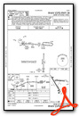
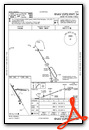
Nearby Airports with Instrument Procedures
| ID | Name | Heading / Distance | ||
|---|---|---|---|---|
 |
75J | Turner County Airport | 334° | 17.1 |
|
15J | Cook County Airport | 174° | 17.6 |
|
4J2 | Berrien County Airport | 133° | 18.8 |
|
KFZG | Fitzgerald Municipal Airport | 036° | 18.9 |
|
KMGR | Moultrie Municipal Airport | 218° | 26.2 |
|
KVAD | Moody AFB Airport | 150° | 31.5 |
|
KDQH | Douglas Municipal Airport | 084° | 32.4 |
|
KCKF | Crisp County-Cordele Airport | 336° | 36.5 |
|
KABY | Southwest Georgia Regional Airport | 280° | 36.7 |
|
KTVI | Thomasville Regional Airport | 212° | 37.5 |
|
4J5 | Quitman Brooks County Airport | 187° | 37.7 |
|
KCXU | Camilla-Mitchell County Airport | 251° | 40.5 |
Airport Images
Do you have a recent image of this airport? Upload it here!


