Login
Register
VA61
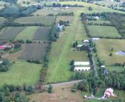
Lovettsville Vintage Aerodrome Airport
Official FAA Data Effective 2024-11-28 0901Z
VFR Chart of VA61
Sectional Charts at SkyVector.com
IFR Chart of VA61
Enroute Charts at SkyVector.com
Location Information for VA61
Coordinates: N39°15.89' / W77°39.22'Located 01 miles SW of Lovettsville, Virginia on 30 acres of land. View all Airports in Virginia.
Surveyed Elevation is 529 feet MSL.
Operations Data
|
|
Airport Communications
| AWOS-3 at JYO (12.1 S): | 125.225 703-777-3781 |
|---|---|
| ATIS at FDK (15.8 NE): | 124.875 |
| AWOS-3 at FDK (16.1 NE): | 301-600-1457 |
Nearby Navigation Aids
|
| ||||||||||||||||||||||||||||||||||||||||||||||||||||||||||||
Runway 01/19
| Dimensions: | 3000 x 50 feet / 914 x 15 meters | |
|---|---|---|
| Surface: | Turf | |
| Runway 01 | Runway 19 | |
| Traffic Pattern: | Left | Right |
Services Available
| Fuel: | NONE |
|---|---|
| Transient Storage: | NONE |
| Airframe Repair: | MINOR |
| Engine Repair: | MINOR |
| Bottled Oxygen: | NOT AVAILABLE |
| Bulk Oxygen: | NOT AVAILABLE |
Ownership Information
| Ownership: | Privately Owned | |
|---|---|---|
| Owner: | THOMAS C. POMEROY | |
| 12582 LUTHERAN CHURCH ROAD | ||
| LOVETTSVILLE, VA 20180 | ||
| 571-919-7800 | ||
| Manager: | THOMAS C. POMEROY | |
| 12582 LUTHERAN CHURCH ROAD | ||
| LOVETTSVILLE, VA 20180 | ||
| (571) 919-7800 | ||
Other Remarks
- DEER AND GEESE INVOF OF ARPT.
- CALL DURING WINTER AND EARLY SPRING OR AFTER HEAVY RAIN TO CONFIRM RWY CONDITION.
- COLOCATED AEROBATIC PRACTICE AREA - CHECK NOTAMS FOR DAYS & HOURS OF USE.
Nearby Airports with Instrument Procedures
| ID | Name | Heading / Distance | ||
|---|---|---|---|---|
 |
KJYO | Leesburg Exec Airport | 158° | 12.1 |
 |
KFDK | Frederick Municipal Airport | 054° | 15.9 |
 |
KMRB | Eastern Wv Regional/Shepherd Field Airport | 298° | 17.4 |
 |
KIAD | Washington Dulles International Airport | 154° | 21.1 |
 |
W50 | Davis Airport | 093° | 23.5 |
 |
KGAI | Montgomery County Airpark Airport | 104° | 23.5 |
 |
KOKV | Winchester Regional Airport | 252° | 24.0 |
 |
KHGR | Hagerstown Regional/Richard A Henson Field Airport | 352° | 26.8 |
 |
2W2 | Clearview Airpark Airport | 067° | 32.0 |
 |
KHEF | Manassas Regional/Harry P Davis Field Airport | 168° | 33.2 |
 |
KFRR | Front Royal-Warren County Airport | 233° | 34.9 |
 |
W35 | Potomac Airpark Airport | 317° | 35.0 |


