Login
Register


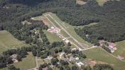
2W2
Clearview Airpark Airport
Official FAA Data Effective 2025-11-27 0901Z
Chart Supplement

VFR Chart of 2W2
Sectional Charts at SkyVector.com
IFR Chart of 2W2
Enroute Charts at SkyVector.com
Location Information for 2W2
Coordinates: N39°28.02' / W77°1.05'Located 07 miles S of Westminster, Maryland on 49 acres of land. View all Airports in Maryland.
Surveyed Elevation is 798 feet MSL.
Operations Data
|
|
Airport Communications
| POTOMAC APPROACH: | 125.525 291.625 |
|---|---|
| POTOMAC DEPARTURE: | 125.525 291.625 |
| CTAF: | 122.800 |
| UNICOM: | 122.800 |
| AWOS-3 at DMW (8.5 N): | 121.25 410-876-1281 |
| AWOS-3 at FDK (16.6 W): | 301-600-1457 |
| ATIS at FDK (16.8 W): | 124.875 |
Nearby Navigation Aids
|
| ||||||||||||||||||||||||||||||||||||||||||||||||||||||||||||


Runway 14/32
| Dimensions: | 1840 x 30 feet / 561 x 9 meters | |
|---|---|---|
| Surface: | Asphalt in Good Condition | |
| Edge Lighting: | Low Intensity NSTD - LGTS 20 FT FM RWY EDGE. | |
| Runway 14 | Runway 32 | |
| Coordinates: | N39°28.11' / W77°1.21' | N39°27.94' / W77°0.89' |
| Elevation: | 760.3 | 798.6 |
| Traffic Pattern: | Left | Left |
| Runway Heading: | 125° True | 305° True |
| Displaced Threshold: | 277 Feet | |
| Markings: | Non-Precision Instrument in good condition. | Non-Precision Instrument in good condition. |
| Glide Slope Indicator | PNIL (4.00° Glide Path Angle) | PNIL (7.00° Glide Path Angle) |
| Obstacles: | 34 ft Trees 693 ft from runway, 134 ft left of center 40 FT TREES, 124 FT LEFT OF THLD. |
88 ft Trees 2316 ft from runway, 121 ft left of center APCH RATIO 20:1 TO DSPLCD THR. 10 FT PVT ROAD AT THLD; 60 FT TREES, 140 FT RIGHT. |
Services Available
| Fuel: | 100LL (blue) |
|---|---|
| Transient Storage: | Tiedowns |
| Airframe Repair: | NONE |
| Engine Repair: | NONE |
| Bottled Oxygen: | NONE |
| Bulk Oxygen: | NONE |
| Other Services: | PILOT INSTRUCTION,AIRCRAFT RENTAL |
Ownership Information
| Ownership: | Privately Owned | |
|---|---|---|
| Owner: | CLEARVIEW AIRPORT INC | |
| 526 OAK TREE ROAD | ||
| WESTMINSTER, MD 21157 | ||
| 410-795-1176 | ||
| Manager: | WALTER S. TEGELER, III | |
| 519 OAK TREE ROAD | ||
| WESTMINSTER, MD 21157 | ||
| 410-984-2434 | ||
Other Remarks
- 60 FT DROP OFF 125 FT FM AER 14.
- ULTRALIGHT ACT ON & INVOF ARPT.
- UNL VEHICLE ACES TO ACFT MOVEMENT AREAS.
- FOR CD CTC POTOMAC APCH AT 866-429-5882.
- ACTVT LIRL RWY 14/32 - CTAF.
- ACTVT ROTG BCN - CTAF.
Weather Minimums
Standard Terminal Arrival (STAR) Charts


Instrument Approach Procedure (IAP) Charts


Nearby Airports with Instrument Procedures
| ID | Name | Heading / Distance | ||
|---|---|---|---|---|
 |
KDMW | Carroll County Regional/Jack B Poage Field Airport | 003° | 8.5 |
|
W50 | Davis Airport | 204° | 14.8 |
|
KFDK | Frederick Municipal Airport | 259° | 16.9 |
|
KGAI | Montgomery County Airpark Airport | 201° | 19.2 |
|
KBWI | Baltimore/Washington International Thurgood Marshall Airport | 136° | 23.8 |
|
W05 | Gettysburg Regional Airport | 332° | 25.4 |
|
KFME | Tipton Airport | 152° | 25.8 |
|
KTHV | York Airport | 013° | 27.8 |
|
KMTN | Martin State Airport | 106° | 29.3 |
|
KCGS | College Park Airport | 171° | 29.5 |
|
W00 | Freeway Airport | 159° | 33.5 |
|
KJYO | Leesburg Exec Airport | 227° | 34.3 |