Login
Register
W29
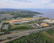
Bay Bridge Airport
Official FAA Data Effective 2026-01-22 0901Z
VFR Chart of W29
Sectional Charts at SkyVector.com
IFR Chart of W29
Enroute Charts at SkyVector.com
Location Information for W29
Coordinates: N38°58.59' / W76°19.80'Located 01 miles W of Stevensville, Maryland on 72 acres of land. View all Airports in Maryland.
Surveyed Elevation is 14 feet MSL.
Operations Data
|
|
Airport Communications
| AWOS-3: | 120.575 Tel. 410-643-8795 |
|---|---|
| POTOMAC APPROACH: | 119.0 282.275 |
| POTOMAC DEPARTURE: | 119.0 282.275 |
| CTAF: | 122.725 |
| UNICOM: | 122.725 |
| AWOS-3PT at ESN (16.0 SE): | 124.475 410-822-2817 |
| ATIS at ESN (16.0 SE): | 124.475 |
| ASOS at BWI (19.8 NW): | 227-217-0474 |
Nearby Navigation Aids
|
| ||||||||||||||||||||||||||||||||||||||||||||||||||||||||||||
Runway 11/29
| Dimensions: | 2714 x 60 feet / 827 x 18 meters | |
|---|---|---|
| Surface: | Asphalt in Good Condition | |
| Edge Lighting: | Medium Intensity | |
| Runway 11 | Runway 29 | |
| Coordinates: | N38°58.64' / W76°20.08' | N38°58.54' / W76°19.52' |
| Elevation: | 6.2 | 14.5 |
| Traffic Pattern: | Left | Left |
| Runway Heading: | 103° True | 283° True |
| Markings: | Non-Precision Instrument in good condition. | Non-Precision Instrument in good condition. |
| Glide Slope Indicator | P2L (3.00° Glide Path Angle) PAPI UNUSBL BYD 5 DEGS LEFT OF CNTRLN. | P2L (3.00° Glide Path Angle) |
| REIL: | Yes | Yes |
Services Available
| Fuel: | 100LL (blue) |
|---|---|
| Transient Storage: | Tiedowns |
| Airframe Repair: | MAJOR |
| Engine Repair: | MAJOR |
| Bottled Oxygen: | NONE |
| Bulk Oxygen: | NONE |
| Other Services: | PILOT INSTRUCTION,AIRCRAFT RENTAL,AIRCRAFT SALES |
Ownership Information
| Ownership: | Publicly owned | |
|---|---|---|
| Owner: | QUEEN ANNE COUNTY | |
| 107 N LIBERTY ST | ||
| STEVENSVILLE, MD 21617 | ||
| 410-798-4098 | ||
| Manager: | LINDA K. STEINER | |
| 202 AIRPORT RD | ||
| STEVENSVILLE, MD 21666 | ||
| 410-643-4364 | ||
Other Remarks
- TGL OPS NA.
- WILDLIFE ON & INVOF ARPT.
- NOISE ABATEMENT PROC IN EFCT - AMGR. NOISE SENSITIVE RESIDENTIAL AREA S OF ARPT; ENTER DOWNWIND FOR RWY 29 OVER WATER TWR S OF FLD.
- ALERT HELI 8 NM EAST OF ARPT.
- FOR CD CTC POTOMAC APCH AT 866-429-5882.
- ROTOR CRAFT: USE R PAT FOR RWY 29. AT ALL OTR TIMES, USE L TFC PAT.
- PRKG FEE.
- 0LL SELF SERVE AVBL H24 WITH CREDIT CARD.
- DUSK-DAWN; ACTVT REIL RWY 11 & 29; MIRL RWY 11/29 - CTAF. PAPI RWY 11 & RWY 29 OPRS CONSLY.
Weather Minimums
Instrument Approach Procedure (IAP) Charts
Nearby Airports with Instrument Procedures
| ID | Name | Heading / Distance | ||
|---|---|---|---|---|
 |
KANP | Lee Airport | 259° | 11.3 |
 |
KESN | Easton/Newnam Field Airport | 130° | 16.0 |
 |
KBWI | Baltimore/Washington International Thurgood Marshall Airport | 307° | 19.8 |
 |
W00 | Freeway Airport | 264° | 20.8 |
 |
KFME | Fort Meade Exec Airport | 288° | 21.1 |
 |
KMTN | Martin State Airport | 349° | 21.3 |
 |
KRJD | Gooden Airpark Airport | 090° | 21.7 |
 |
KADW | Joint Base Andrews Airport | 248° | 27.1 |
 |
KCGS | College Park Airport | 270° | 27.7 |
 |
KCGE | Cambridge-Dorchester Regional Airport | 151° | 29.7 |
 |
KVKX | Potomac Airfield Airport | 245° | 32.4 |
 |
KDCA | Ronald Reagan Washington Ntl Airport | 257° | 34.0 |


