



Login
Register
06FD
Grass Roots Airpark Airport
Official FAA Data Effective 2026-10-01 0901Z
VFR Chart of 06FD
Sectional Charts at SkyVector.com
IFR Chart of 06FD
Enroute Charts at SkyVector.com
Location Information for 06FD
Coordinates: N28°38.50' / W81°53.10'Located 04 miles N of Mascotte, Florida on 104 acres of land. View all Airports in Florida.
Estimated Elevation is 105 feet MSL.
Operations Data
|
|
Airport Communications
| ASOS at LEE (11.5 N): | 352-787-1565 |
|---|---|
| ATIS at LEE (11.6 N): | 134.325 |
| AWOS-3 at INF (24.9 NW): | 119.975 352-560-6012 |
Nearby Navigation Aids
|
| ||||||||||||||||||||||||||||||||||||||||||


Runway 18/36
| Dimensions: | 3400 x 120 feet / 1036 x 37 meters | |
|---|---|---|
| Surface: | Turf | |
| Runway 18 | Runway 36 | |
| Obstacles: | 15 ft Road 340 ft from runway | 30 ft Trees 620 ft from runway |
Ownership Information
| Ownership: | Privately Owned | |
|---|---|---|
| Owner: | GRASS ROOTS AIRPARK | |
| 808 W. NEW HAMPSHIRE STREET | ||
| ORLANDO, FL 32804 | ||
| 407-649-4959 | ||
| Manager: | DAVID GAY | |
| 808 W. NEW HAMPSHIRE STREET | ||
| ORLANDO, FL 32804 | ||
| 407-234-6986 | ||
Other Remarks
- FOR CD CTC ORLANDO APCH AT 407-852-7553.
Nearby Airports with Instrument Procedures
| ID | Name | Heading / Distance | ||
|---|---|---|---|---|
 |
KLEE | Leesburg International Airport | 020° | 11.6 |
|
X04 | Orlando Apopka Airport | 076° | 16.5 |
|
X23 | Umatilla Municipal Airport | 035° | 20.9 |
|
KINF | Inverness Airport | 293° | 24.8 |
|
KZPH | Zephyrhills Municipal Airport | 210° | 28.7 |
|
KORL | Orlando Exec Airport | 101° | 29.7 |
|
KISM | Kissimmee Gateway Airport | 131° | 31.7 |
|
KBKV | Brooksville-Tampa Bay Regional Airport | 251° | 31.8 |
|
KMCO | Orlando International Airport | 112° | 33.0 |
|
KSFB | Orlando Sanford International Airport | 076° | 35.2 |
|
KGIF | Winter Haven Regional Airport | 168° | 35.3 |
|
X35 | Marion County Airport | 314° | 36.1 |
Airport Images
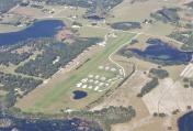
By: chabrier



