Login
Register


08D
Stanley Municipal Airport
Official FAA Data Effective 2025-12-25 0901Z
Chart Supplement

VFR Chart of 08D
Sectional Charts at SkyVector.com
IFR Chart of 08D
Enroute Charts at SkyVector.com
Location Information for 08D
Coordinates: N48°18.08' / W102°24.48'Located 01 miles SW of Stanley, North Dakota on 80 acres of land. View all Airports in North Dakota.
Surveyed Elevation is 2249 feet MSL.
Operations Data
|
|
Airport Communications
| AWOS-3: | 121.1 Tel. 701-628-1737 |
|---|---|
| CTAF: | 122.900 |
| AWOS-3 at D60 (20.2 W): | 118.575 701-664-4490 |
| ATIS at MIB (42.4 E): | 278.8 |
| ASOS at MIB (43.0 E): |
- APCH/DEP SVC PRVDD BY MINNEAPOLIS ARTCC ON FREQS 127.6/279.6 (MINOT RCAG).
Nearby Navigation Aids
|
| ||||||||||||||||||||||||||||||


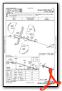
Runway 10/28
| Dimensions: | 3900 x 60 feet / 1189 x 18 meters | |
|---|---|---|
| Surface: | Asphalt in Good Condition | |
| Weight Limits: | S-14 | |
| Edge Lighting: | Medium Intensity | |
| Runway 10 | Runway 28 | |
| Coordinates: | N48°18.16' / W102°24.86' | N48°17.95' / W102°23.95' |
| Elevation: | 2249.6 | 2241.3 |
| Traffic Pattern: | Left | Left |
| Runway Heading: | 108° True | 288° True |
| Markings: | Non-Precision Instrument in good condition. | Non-Precision Instrument in good condition. |
| Glide Slope Indicator | P2L (3.00° Glide Path Angle) | P2L (3.00° Glide Path Angle) |
Runway 02/20
| Dimensions: | 1185 x 120 feet / 361 x 37 meters | |
|---|---|---|
| Surface: | Turf | |
| Runway 02 | Runway 20 | |
| Coordinates: | N48°18.10' / W102°24.82' | N48°18.27' / W102°24.67' |
| Elevation: | 2243.2 | 2244.7 |
| Runway Heading: | 31° True | 211° True |
Services Available
| Fuel: | 100LL (blue), Jet A+, Automotive Gasoline |
|---|---|
| Transient Storage: | Hangars,Tiedowns |
| Airframe Repair: | NONE |
| Engine Repair: | NONE |
| Bottled Oxygen: | NONE |
| Bulk Oxygen: | NONE |
| Other Services: | CROP DUSTING SERVICES,PILOT INSTRUCTION |
Ownership Information
| Ownership: | Publicly owned | |
|---|---|---|
| Owner: | STANLEY ARPT AUTH | CHAIRMAN: GREG JOHNSON 701-240-9635. |
| PO BOX 252 | ||
| STANLEY, ND 58784 | ||
| 701-629-0061 | ||
| Manager: | STEVEN MARTENS | |
| PO BOX 252 | ||
| STANLEY, ND 58784 | ||
| 701-629-0061 | ||
Other Remarks
- DUE TO SNOW NOV-MAR CALL 701-629-0061 OR 701-629-1244 TO CHECK ON RWY COND PRIOR TO USE.
- DEER & BIRDS ON & INVOF ARPT.
- FOR CD CTC MINNEAPOLIS ARTCC AT 651-463-5588.
- 0LL SELF SVC FUEL AVBL H24 VIA CREDIT CARD.
- ACTVT PAPI RWY 10 & 28; MIRL RWY 10/28 - CTAF.
Weather Minimums
Instrument Approach Procedure (IAP) Charts

Nearby Airports with Instrument Procedures
| ID | Name | Heading / Distance | ||
|---|---|---|---|---|
 |
D60 | Tioga Municipal Airport | 283° | 20.2 |
|
05D | New Town Municipal Airport | 188° | 20.2 |
|
7K5 | Kenmare Municipal Airport | 033° | 26.3 |
|
KMIB | Minot AFB Airport | 080° | 42.6 |
|
KHBC | Mohall Municipal Airport | 050° | 44.6 |
|
KMOT | Minot International Airport | 092° | 45.4 |
|
S25 | Watford City Municipal Airport | 228° | 45.6 |
|
D50 | Crosby Municipal Airport | 317° | 51.7 |
|
KXWA | Williston Basin International Airport | 267° | 53.9 |
|
D05 | Garrison Municipal Airport | 134° | 55.1 |
|
9Y1 | Dunn County Weydahl Field Airport | 195° | 56.6 |
|
KHZE | Mercer County Regional Airport | 150° | 69.3 |


