Login
Register


D50
Crosby Municipal Airport
Official FAA Data Effective 2026-02-19 0901Z
Chart Supplement

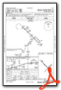
VFR Chart of D50
Sectional Charts at SkyVector.com
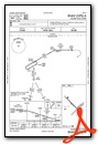
IFR Chart of D50
Enroute Charts at SkyVector.com
Location Information for D50
Coordinates: N48°55.70' / W103°17.85'Located 01 miles N of Crosby, North Dakota on 217 acres of land. View all Airports in North Dakota.
Surveyed Elevation is 1952 feet MSL.
Operations Data
|
|
Airport Communications
| AWOS-3: | 118.025 Tel. 701-965-6732 |
|---|---|
| CTAF: | 122.900 |
| AWOS-3 at D60 (36.3 SE): | 118.575 701-664-4490 |
| ASOS at XWA (44.2 SW): | 125.925 701-289-3089 |
| AWOS-3PT at PWD (49.1 W): | 135.025 406-765-2149 |
- APCH/DEP CTL SVC PRVDD BY SALT LAKE CITY ARTCC( ZLC) ON FREQS 126.85/305.2 (GLASGOW RCAG).
Nearby Navigation Aids
|
| ||||||||||||||||||||||||


Runway 13/31
| Dimensions: | 3800 x 75 feet / 1158 x 23 meters | |
|---|---|---|
| Surface: | Asphalt in Good Condition | |
| Weight Limits: | S-12 | |
| Edge Lighting: | Medium Intensity | |
| Runway 13 | Runway 31 | |
| Coordinates: | N48°55.97' / W103°18.27' | N48°55.53' / W103°17.60' |
| Elevation: | 1952.6 | 1946.4 |
| Traffic Pattern: | Left | Left |
| Runway Heading: | 134° True | 314° True |
| Markings: | Non-Precision Instrument in good condition. | Non-Precision Instrument in good condition. |
| Glide Slope Indicator | P2L (3.00° Glide Path Angle) | P2L (3.00° Glide Path Angle) |
Runway 03/21
CLSD WINTER MONTHS DUE TO LACK OF SNOW REMOVAL. | ||
| Dimensions: | 2680 x 100 feet / 817 x 30 meters | |
|---|---|---|
| Surface: | Turf in Good Condition | |
| Runway 03 | Runway 21 | |
| Coordinates: | N48°55.47' / W103°17.98' | N48°55.78' / W103°17.50' |
| Elevation: | 1949.2 | 1941.6 |
| Traffic Pattern: | Left | Left |
| Runway Heading: | 45° True | 225° True |
| Markings: | Non-Precision Instrument in good condition. | Non-Precision Instrument in good condition. |
Services Available
| Fuel: | 100LL (blue) |
|---|---|
| Transient Storage: | Tiedowns |
| Airframe Repair: | NONE |
| Engine Repair: | NONE |
| Bottled Oxygen: | NONE |
| Bulk Oxygen: | NONE |
| Other Services: | CROP DUSTING SERVICES FOR AGRI SVCS CTC 701-965-4284/6146 OR 701-570-0944. |
Ownership Information
| Ownership: | Publicly owned | |
|---|---|---|
| Owner: | CROSBY ARPT AUTH | |
| PO BOX 882 | ||
| CROSBY, ND 58730 | ||
| (701) 570-0944 | ||
| Manager: | MIKE MELBY | ARPT MAINT & SNOW RMVL CTC PERSON. |
| PO BOX 154 | ||
| CROSBY, ND 58730 | ||
| 701-570-0944 | HOME PHONE 701-965-4284; ADNL CTC NEIL BENTER 701-641-8554, 701-965-6512, OR 701-965-6775. | |
Other Remarks
- +250' TOWER 4000' SOUTH OF ARPT.
- DEER AND BIRDS ON & INVOF ARPT.
- FOR CD CTC SALT LAKE ARTCC AT 801-320-2568.
- 0LL SELF SVC FUEL AVBL H24 VIA CREDIT CARD.
- PAPI RWY 13 & 31 OPER DUSK-0100. MIRL RWY 13/31 PRESET ON LOW INTST DUSK-0100; TO INCR INTST ACTVT - CTAF. AFT 0100 ACTVT MIRL RWY 13/31; PAPI RWY 13 & 31 - CTAF.
Weather Minimums


Instrument Approach Procedure (IAP) Charts
Nearby Airports with Instrument Procedures
| ID | Name | Heading / Distance | ||
|---|---|---|---|---|
 |
D60 | Tioga Municipal Airport | 154° | 36.6 |
|
KXWA | Williston Basin International Airport | 204° | 44.0 |
|
KPWD | Sher-Wood Airport | 260° | 49.3 |
|
08D | Stanley Municipal Airport | 136° | 51.7 |
|
7K5 | Kenmare Municipal Airport | 107° | 52.0 |
|
05D | New Town Municipal Airport | 150° | 66.3 |
|
S25 | Watford City Municipal Airport | 178° | 68.2 |
|
KHBC | Mohall Municipal Airport | 097° | 70.4 |
|
KSDY | Sidney-Richland Regional Airport | 206° | 81.6 |
|
KMIB | Minot AFB Airport | 111° | 83.0 |
|
9S2 | Scobey Airport | 265° | 85.2 |
|
PO1 | Poplar Municipal Airport | 238° | 88.3 |
Airport Images
Do you have a recent image of this airport? Upload it here!


