Login
Register


HEG
Herlong Recreational Airport
Official FAA Data Effective 2026-02-19 0901Z
Chart Supplement

VFR Chart of KHEG
Sectional Charts at SkyVector.com
IFR Chart of KHEG
Enroute Charts at SkyVector.com
Location Information for KHEG
Coordinates: N30°16.67' / W81°48.36'Located 08 miles SW of Jacksonville, Florida on 1484 acres of land. View all Airports in Florida.
Surveyed Elevation is 85 feet MSL.
Operations Data
|
|
Airport Communications
| AWOS-3: | 119.275 Tel. 904-741-2224 |
|---|---|
| JACKSONVILLE APPROACH: | 127.775 127.775 377.075 |
| JACKSONVILLE DEPARTURE: | 127.775 |
| CTAF: | 123.000 |
| UNICOM: | 123.000 |
| ATIS at VQQ (5.1 SW): | 125.275 |
| AWOS-3 at VQQ (5.1 SW): | 125.275 904-778-6934 |
| ATIS at NIP (7.2 E): | 290.425 |
Nearby Navigation Aids
|
| ||||||||||||||||||||||||||||||||||||||||||||||||||||||


Runway 07/25
| Dimensions: | 4001 x 100 feet / 1220 x 30 meters | |
|---|---|---|
| Surface: | Asphalt in Fair Condition | |
| Weight Limits: | 11 /F/B/Y/T, S-30 | |
| Edge Lighting: | Medium Intensity | |
| Runway 07 | Runway 25 | |
| Coordinates: | N30°16.58' / W81°48.89' | N30°16.86' / W81°48.21' |
| Elevation: | 73.4 | 79.9 |
| Traffic Pattern: | Left | Left |
| Runway Heading: | 65° True | 245° True |
| Markings: | Basic in good condition. | Non-Precision Instrument in good condition. |
| Glide Slope Indicator | P2L (3.00° Glide Path Angle) | P2L (3.00° Glide Path Angle) |
| Obstacles: | 50 ft Tree 1395 ft from runway, 210 ft right of center | 60 ft Trees 2215 ft from runway, 50 ft right of center |
Runway 11/29
| Dimensions: | 3500 x 100 feet / 1067 x 30 meters | |
|---|---|---|
| Surface: | Asphalt in Excellent Condition | |
| Weight Limits: | 6 /F/B/Y/T, S-30 | |
| Edge Lighting: | Medium Intensity | |
| Runway 11 | Runway 29 | |
| Coordinates: | N30°16.70' / W81°48.45' | N30°16.51' / W81°47.82' |
| Elevation: | 84.6 | 82.7 |
| Traffic Pattern: | Left | Left |
| Runway Heading: | 110° True | 290° True |
| Markings: | Basic in fair condition. | Basic in fair condition. |
| Glide Slope Indicator | P2L (3.00° Glide Path Angle) | P2L (3.00° Glide Path Angle) |
| Obstacles: | 76 ft Trees 2235 ft from runway | 50 ft Trees 1035 ft from runway, 65 ft right of center |
Services Available
| Fuel: | 100LL (blue), Jet-A |
|---|---|
| Transient Storage: | Hangars,Tiedowns |
| Airframe Repair: | MAJOR |
| Engine Repair: | MAJOR |
| Bottled Oxygen: | NONE |
| Bulk Oxygen: | NONE |
| Other Services: | AVIONICS,CHARTER SERVICE,GLIDER SERVICE,PILOT INSTRUCTION,PARACHUTE JUMP ACTIVITY,AIRCRAFT RENTAL,AIRCRAFT SALES,GLIDER TOWING SERVICES |
Ownership Information
| Ownership: | Publicly owned | |
|---|---|---|
| Owner: | JACKSONVILLE AVIATION AUTHORITY | 904-741-2040. |
| 14201 PECAN PARK ROAD | ||
| JACKSONVILLE, FL 32218 | ||
| 904-741-2069 | ||
| Manager: | ROLF RIECHMANN | |
| 9300 NORMANDY BLVD., SUITE 4 | ||
| JACKSONVILLE, FL 32221-5522 | ||
| 904-783-2805 | FBO (904) 783-2805. | |
Other Remarks
- ULTRALIGHT & GLIDER ACTIVITY ON & INVOF ARPT.
- GCO AVBL ON FREQ 121.725 THRU JACKSONVILLE ARTCC CD AND GAINESVILLE FSS.
- FOR CD IF UNA VIA GCO CTC JACKSONVILLE ARTCC AT 904-741-0284.
- ACTVT MIRL RWY 07/25 & 11/29 - CTAF.
Weather Minimums
Standard Terminal Arrival (STAR) Charts
Instrument Approach Procedure (IAP) Charts
Nearby Airports with Instrument Procedures
| ID | Name | Heading / Distance | ||
|---|---|---|---|---|
 |
KVQQ | Cecil Airport | 226° | 5.1 |
|
KNIP | Jacksonville NAS (Towers Field) Airport | 111° | 7.2 |
|
KJAX | Jacksonville International Airport | 025° | 14.3 |
|
KCRG | Jacksonville Exec At Craig Airport | 076° | 15.5 |
|
KNRB | Mayport Ns (Adm David L Mcdonald Field) Airport | 070° | 20.9 |
|
KFHB | Fernandina Beach Municipal Airport | 041° | 26.8 |
|
42J | Keystone Heights Airport | 205° | 28.8 |
|
KSGJ | St Augustine Airport | 128° | 30.9 |
|
28J | Palatka Municipal/Lt Kay Larkin Field Airport | 170° | 37.6 |
|
KLCQ | Lake City Gateway Airport | 262° | 40.5 |
|
KGNV | Gainesville Regional Airport | 214° | 42.7 |
|
09J | Jekyll Island Airport | 022° | 51.5 |
Airport Images
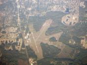
By: Dave


