Login
Register


0A9
William B Greene Jr Regional Airport
Official FAA Data Effective 2026-01-22 0901Z
Chart Supplement

VFR Chart of 0A9
Sectional Charts at SkyVector.com
IFR Chart of 0A9
Enroute Charts at SkyVector.com
Location Information for 0A9
Coordinates: N36°22.29' / W82°10.36'Located 03 miles NE of Elizabethton, Tennessee on 96 acres of land. View all Airports in Tennessee.
Estimated Elevation is 1592 feet MSL.
Operations Data
|
|
Airport Communications
| AWOS-3PT: | 135.675 Tel. 423-543-1801 |
|---|---|
| TRI CITY APPROACH: | 125.25 134.425 349.0 |
| TRI CITY DEPARTURE: | 125.25 134.425 349.0 |
| CTAF: | 123.000 |
| UNICOM: | 123.000 |
| ASOS at TRI (12.7 NW): | 118.25 423-218-2712 |
| ATIS at TRI (12.9 NW): | 118.25 |
| AWOS-3 at 6A4 (17.0 E): | 126.225 423-727-4365 |
- APCH/DEP SVC PRVDD BY ATLANTA ARTCC ON FREQS 127.85/269.3 (GLADE SPRINGS RCAG) WHEN TRI CITY APCH CTL CLSD.
Nearby Navigation Aids
|
| ||||||||||||||||||||||||||||||||||||||||||||||||||||||||||||


Runway 06/24
| Dimensions: | 5001 x 70 feet / 1524 x 21 meters | |
|---|---|---|
| Surface: | Asphalt in Excellent Condition | |
| Weight Limits: | S-25 | |
| Edge Lighting: | Low Intensity NSTD | |
| Runway 06 | Runway 24 | |
| Coordinates: | N36°22.07' / W82°10.79' | N36°22.51' / W82°9.93' |
| Elevation: | 1555.8 | 1592.5 |
| Traffic Pattern: | Right | Left |
| Runway Heading: | 58° True | 238° True |
| Displaced Threshold: | 97 Feet | 902 Feet |
| Declared Distances: | TORA:5001 TODA:5001 ASDA:5001 LDA:4904 | TORA:5001 TODA:5001 ASDA:5001 LDA:4099 |
| Markings: | Non-Precision Instrument in good condition. | Non-Precision Instrument in good condition. |
| Glide Slope Indicator | S2L (3.75° Glide Path Angle) | |
| REIL: | Yes | |
| Obstacles: | 117 ft Tree 1622 ft from runway, 380 ft right of center APCH SLOPE 27:1 TO DTHR. |
73 ft Tree 976 ft from runway, 9 ft right of center |
Services Available
| Fuel: | 100LL (blue), Jet-A |
|---|---|
| Transient Storage: | Hangars,Tiedowns |
| Airframe Repair: | NOT AVAILABLE |
| Engine Repair: | NOT AVAILABLE |
| Bottled Oxygen: | NOT AVAILABLE |
| Bulk Oxygen: | NOT AVAILABLE |
| Other Services: | PILOT INSTRUCTION,AIRCRAFT RENTAL |
Ownership Information
| Ownership: | Publicly owned | |
|---|---|---|
| Owner: | CITY OF ELIZABETHTON | |
| 136 SOUTH SYCAMORE STREET | ||
| ELIZABETHTON, TN 37643 | ||
| (423) 547-6200 | ||
| Manager: | DAN COGAN | |
| 415 HIGHWAY 91 | ||
| ELIZABETHTON, TN 37643 | ||
| 423-543-2801 | ||
Other Remarks
- THIS AIRPORT HAS BEEN SURVEYED BY THE NATIONAL GEODETIC SURVEY.
- COLD TEMPERATURE AIRPORT. ALTITUDE CORRECTION REQUIRED AT OR BELOW -10C.
- FOR CD CTC ATLANTA ARTCC AT 770-210-7692.
- DALGT OPS ONLY. HIGH PERF DEP MNTN RWY HDG UNTIL 2600 FT MSL.
- ACTVT REIL RWY 06 - CTAF. LIRL RWY 6/24 PPR - AMGR.
Weather Minimums


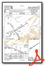
Instrument Approach Procedure (IAP) Charts
Nearby Airports with Instrument Procedures
| ID | Name | Heading / Distance | ||
|---|---|---|---|---|
 |
KTRI | Tri-Cities Airport | 298° | 13.0 |
|
6A4 | Johnson County Airport | 080° | 17.1 |
|
KVJI | Virginia Highlands Airport | 019° | 20.0 |
|
KGCY | Greeneville Municipal Airport | 251° | 32.7 |
|
KRVN | Hawkins County Airport | 278° | 34.9 |
|
KGEV | Ashe County Airport | 084° | 36.7 |
|
KLNP | Lonesome Pine Airport | 335° | 40.7 |
|
KMRN | Foothills Regional Airport | 140° | 42.8 |
|
KJFZ | Tazewell County Airport | 023° | 45.2 |
|
KMKJ | Mountain Empire Airport | 051° | 50.6 |
|
KUKF | Wilkes County Airport | 099° | 52.8 |
|
0VG | Lee County Airport | 288° | 53.3 |
Fuel Providers

Airport Images

By: rettm5


