Login
Register


0B4
Hartington Municipal/Bud Becker Field Airport
Official FAA Data Effective 2025-11-27 0901Z
Chart Supplement

VFR Chart of 0B4
Sectional Charts at SkyVector.com
IFR Chart of 0B4
Enroute Charts at SkyVector.com
Location Information for 0B4
Coordinates: N42°36.18' / W97°15.21'Located 02 miles SE of Hartington, Nebraska on 243 acres of land. View all Airports in Nebraska.
Surveyed Elevation is 1388 feet MSL.
Operations Data
|
|
Airport Communications
| CTAF: | 122.900 |
|---|---|
| AWOS-3P at VMR (17.1 NE): | 118.650 |
| AWOS-3PT at YKN (19.7 N): | 119.05 605-665-6072 |
| AWOS-3 at LCG (24.8 SE): | 120.125 402-375-0111 |
- APCH/DEP SVC PRVDD BY MINNEAPOLIS ARTCC ON FREQS 125.025/235.625 (SIOUX CITY RCAG).
Nearby Navigation Aids
|
| ||||||||||||||||||||||||||||||||||||||||||||||||||||||||||||


Runway 13/31
| Dimensions: | 3950 x 60 feet / 1204 x 18 meters | |
|---|---|---|
| Surface: | Concrete in Good Condition | |
| Edge Lighting: | Medium Intensity | |
| Runway 13 | Runway 31 | |
| Coordinates: | N42°36.47' / W97°15.43' | N42°35.96' / W97°14.88' |
| Elevation: | 1367.1 | 1380.6 |
| Traffic Pattern: | Left | Left |
| Runway Heading: | 141° True | 321° True |
| Displaced Threshold: | 400 Feet | |
| Markings: | Non-Precision Instrument in good condition. | Non-Precision Instrument in good condition. |
| Glide Slope Indicator | P2L (3.50° Glide Path Angle) | P2L (3.25° Glide Path Angle) |
| Obstacles: | 70 ft Tree 1487 ft from runway, 420 ft right of center RWY 13 TREE MASS 1330 FT TO 1250 FT FM RWY END. RWY 13 TREE MASS 300 FT TO 470 FT R OF CNTRLN. |
RWY 31 APCH RATIO 21:1 TO DSPLCD THR DUE TO ROAD 31 FT ABV 675 FT FM DSPLCD THR, 351 FT L. RWY 31 CLOSE-IN OBSTN ROAD 223 RIGHT. |
Runway 03/21
NOT PLOWED DURING WINTER MONTHS. | ||
| Dimensions: | 2150 x 125 feet / 655 x 38 meters | |
|---|---|---|
| Surface: | Turf in Good Condition | |
| Runway 03 | Runway 21 | |
| Coordinates: | N42°36.00' / W97°15.46' | N42°36.27' / W97°15.15' |
| Elevation: | 1387.2 | 1374.2 |
| Traffic Pattern: | Left | Left |
| Runway Heading: | 41° True | 221° True |
Services Available
| Fuel: | 100LL (blue) |
|---|---|
| Transient Storage: | Hangars,Tiedowns |
| Airframe Repair: | MAJOR |
| Engine Repair: | MAJOR |
| Bottled Oxygen: | NONE |
| Bulk Oxygen: | NONE |
| Other Services: | CROP DUSTING SERVICES,PILOT INSTRUCTION |
Ownership Information
| Ownership: | Publicly owned | |
|---|---|---|
| Owner: | HARTINGTON AIRPORT AUTHORITY | AIRPORT AUTHORITY CHAIRMAN IS KARMA SCHULTE |
| P.O. BOX 14, 302 S. CEDAR AVENUE | ||
| HARTINGTON, NE 68739-0014 | ||
| 402-841-0610 | ||
| Manager: | JOHN BECKER | |
| 56395 881 ROAD | ||
| HARTINGTON, NE 68739-4021 | ||
| 402-841-0486 | MOBILE PHONE 402-841-0486 (MANAGER) | |
Other Remarks
- FOR CD CTC MINNEAPOLIS ARTCC AT 651-463-5588.
- 0LL FOR FUEL CALL 402-254-7316 OR 402-841-0486.
- ACTVT PAPI RWY 13 & 31; MIRL RWY 13/31 - CTAF.
Weather Minimums

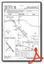
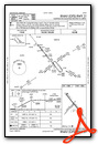
Instrument Approach Procedure (IAP) Charts
Nearby Airports with Instrument Procedures
| ID | Name | Heading / Distance | ||
|---|---|---|---|---|
 |
KVMR | Harold Davidson Field Airport | 055° | 17.2 |
|
KYKN | Chan Gurney Municipal Airport | 342° | 19.7 |
|
KLCG | Wayne Municipal/Stan Morris Field Airport | 150° | 24.8 |
|
6K3 | Creighton Municipal Airport | 254° | 29.1 |
|
0C4 | Pender Municipal Airport | 141° | 37.5 |
|
KOFK | Norfolk Regional/Karl Stefan Memorial Field Airport | 192° | 37.9 |
|
KSUX | Sioux Gateway/Brig General Bud Day Field Airport | 107° | 40.4 |
|
4V9 | Antelope County Airport | 230° | 45.7 |
|
KLRJ | Le Mars Municipal Airport | 076° | 48.1 |
|
KSXK | Sioux County Regional Airport | 064° | 53.4 |
|
KAGZ | Wagner Municipal Airport | 301° | 53.7 |
|
8V3 | Parkston Municipal Airport | 325° | 56.6 |
Airport Images
Do you have a recent image of this airport? Upload it here!


