Login
Register


SUX
Sioux Gateway/Brig General Bud Day Field Airport
Official FAA Data Effective 2025-11-27 0901Z
Chart Supplement

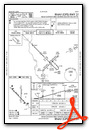
KSUX Airport Diagram

VFR Chart of KSUX
Sectional Charts at SkyVector.com
IFR Chart of KSUX
Enroute Charts at SkyVector.com
Location Information for KSUX
Coordinates: N42°24.08' / W96°23.07'Located 06 miles S of Sioux City, Iowa on 2460 acres of land. View all Airports in Iowa.
Surveyed Elevation is 1098 feet MSL.
Operations Data
|
|
Airport Communications
| ATIS: | 119.45 270.8 |
|---|---|
| ASOS: | 119.45 Tel. 712-317-9924 |
| SIOUX CITY TOWER: | 118.7 254.3 |
| SIOUX CITY GROUND: | 121.9 348.6 |
| SIOUX CITY APPROACH: | 124.6 307.0 |
| SIOUX CITY DEPARTURE: | 124.6 307.0 |
| CTAF: | 118.700 |
| EMERG: | 121.5 |
| ANG COMD POST: | 138.437 373.6 |
| UNICOM: | 122.950 |
| AWOS-3P at LRJ (24.1 N): | 120.975 712-546-8439 |
| AWOS-3 at LCG (28.2 W): | 120.125 402-375-0111 |
| AWOS-3P at VMR (32.6 NW): | 118.650 |
- APCH/DEP SVC PRVDD BY MINNEAPOLIS ARTCC ON FREQS 125.025/235.625 WHEN APCH CTL CLSD (SIOUX CITY RCAG).
Nearby Navigation Aids
|
| ||||||||||||||||||||||||||||||||||||||||||||||||||||||


Runway 13/31
| Dimensions: | 9002 x 150 feet / 2744 x 46 meters | |
|---|---|---|
| Surface: | Concrete / Grooved in Good Condition | |
| Weight Limits: | S-120, D-173, ST-281, DT-685
PCR VALUE: 540/R/C/W/T
| |
| Edge Lighting: | High Intensity | |
| Runway 13 | Runway 31 | |
| Coordinates: | N42°24.55' / W96°23.86' | N42°23.49' / W96°22.47' |
| Elevation: | 1093.1 | 1093.4 |
| Traffic Pattern: | Left | Left |
| Runway Heading: | 136° True | 316° True |
| Declared Distances: | TORA:9002 TODA:9002 ASDA:9002 LDA:9002 | TORA:9002 TODA:9002 ASDA:9002 LDA:9002 |
| Markings: | Precision Instrument in good condition. | Precision Instrument in good condition. |
| Glide Slope Indicator | V4L (3.00° Glide Path Angle) | V4L (3.00° Glide Path Angle) |
| RVR Equipment | Touchdown Rollout | Touchdown Rollout |
| Approach Lights: | MALS 1,400 Foot Medium-intensity Approach Lighting System. | MALSR 1,400 Foot Medium-intensity Approach Lighting System with runway alignment indicator lights. |
| Obstacles: | 72 ft Tree 3100 ft from runway, 475 ft left of center | |
Runway 18/36
| Dimensions: | 6401 x 100 feet / 1951 x 30 meters | |
|---|---|---|
| Surface: | Asphalt / Grooved in Fair Condition | |
| Weight Limits: | S-104, D-139, ST-194, DT-561
PCR VALUE: 430/F/D/X/T
| |
| Edge Lighting: | Medium Intensity | |
| Runway 18 | Runway 36 | |
| Coordinates: | N42°24.69' / W96°22.92' | N42°23.63' / W96°22.93' |
| Elevation: | 1097.6 | 1095.3 |
| Runway Heading: | 181° True | 1° True |
| Declared Distances: | TORA:6400 TODA:6400 ASDA:6400 LDA:6400 | TORA:6400 TODA:6400 ASDA:6400 LDA:6400 |
| Markings: | Non-Precision Instrument in fair condition. | Non-Precision Instrument in fair condition. |
| Glide Slope Indicator | P4R (3.00° Glide Path Angle) | P4L (3.00° Glide Path Angle) |
| REIL: | Yes | |
| Obstacles: | 47 ft Trees 1160 ft from runway, 350 ft right of center | 16 ft Pole 900 ft from runway |
Services Available
| Fuel: | 100LL (blue), Jet-A |
|---|---|
| Transient Storage: | Hangars,Tiedowns |
| Airframe Repair: | MAJOR |
| Engine Repair: | MAJOR |
| Bottled Oxygen: | HIGH/LOW |
| Bulk Oxygen: | HIGH/LOW |
| Other Services: | AIR FREIGHT SERVICES,AIR AMBULANCE SERVICES,CHARTER SERVICE,PILOT INSTRUCTION,AIRCRAFT RENTAL,AIRCRAFT SALES,ANNUAL SURVEYING |
Ownership Information
| Ownership: | Publicly owned | |
|---|---|---|
| Owner: | SIOUX GATEWAY AIRPORT | |
| 2403 AVIATION BLVD. | ||
| SIOUX CITY, IA 51111 | ||
| 712-279-0167 | ||
| Manager: | MR. ALVIN LORENZO | |
| 2403 AVIATION BLVD. | ||
| SIOUX CITY, IA 51111 | ||
| 720-365-6312 | ||
Other Remarks
- (E60-13) BAK12/14 LCTD 1392' FROM THR.
- PAEW 2130-0600 DURING INCLEMENT WEATHER NOV-APR.
- CTN: OCNL BIRDWATCH COND - SEV DRG SPRING/FALL DUE TO MIGRATORY WATERFOWL. CIVILIAN TWR DOES NOT BROADCAST USAF BIRDWATCH COND. CTC AFLD MGMT FOR BIRD STS.
- RY 31 IS CALM WIND RY.
- SERVICE-FLUID: LPOX & LHNIT.
- SERVICE-JASU: 6(A/M32A-86) 6(A/M32-95).
- APCH END RWY 31 - BAK-12(B)/14 LCTD (1492').
- AFLD SURFACE CONDITIONS NOT MONITORED BY ARPT MANAGEMENT BTN 0000 - 0400 LCL DAILY.
- RSTD: ALL MIL OPS OPR 1300-2200Z++ TUE-FRI EXC HOL.
- SERVICE-OIL: JOAP- AVBL ONLY DUR ANG DUTY HR.
- CAUTION: PORTIONS OF TWY A SE OF TWY B NOT VIS BY TWR.
- FUEL: A++
- ATCT HAS LIMITED VISIBILITY OF TWY A NEAR ARFF BLDG AND OF TWY G.
- FOR CD IF UNA TO CTC ON FSS FREQ, CTC MINNEAPOLIS ARTCC AT 651-463-5588.
- APCH END RY 13 - BAK-12/14(B) LCTD(1500').
- PPR FOR USE OF ANG RAMP V(712)-233-0210.
- ANG RMRKS: OFFL BUS ONLY/PPR. COMMAND POST (24 HR OPN) DSN 585-0211 OR 585-0212 OR C712-233-0211/0212. EXTREMELY LIMITED PARKING. TRANS ACFT PAX IDENT & BAGGAGE SEARCH UNAVBL.BASE OPS OPR 1230-2230Z++ TUE-FRI EXC HOL. C712-233-0276 DSN 585-0276.
- FOR FUEL AND SUPPORT AFT HRS BY PPR OR CALL IN.
- DUSK-DAWN. WHEN ATCT CLSD ACTVT MALS RWY 13; MALSR RWY 31; REIL RWY 18; VASI RWY 13 & 31; HIRL RWY 13/31; MIRL RWY 18/36 - CTAF.
- BAK-14 BAK-12B(B) (1392').
- BAK-14 BAK-12B(B) (1492').
Weather Minimums


Instrument Approach Procedure (IAP) Charts


Nearby Airports with Instrument Procedures
| ID | Name | Heading / Distance | ||
|---|---|---|---|---|
 |
0C4 | Pender Municipal Airport | 221° | 23.1 |
|
KLRJ | Le Mars Municipal Airport | 020° | 24.2 |
|
KLCG | Wayne Municipal/Stan Morris Field Airport | 250° | 28.3 |
|
KMEY | James G Whiting Memorial Field Airport | 116° | 29.5 |
|
KVMR | Harold Davidson Field Airport | 312° | 32.7 |
|
KSXK | Sioux County Regional Airport | 015° | 36.4 |
|
KTQE | Tekamah Municipal Airport | 166° | 39.3 |
|
0B4 | Hartington Municipal/Bud Becker Field Airport | 287° | 40.4 |
|
KCKP | Cherokee County Regional Airport | 061° | 41.7 |
|
KSCB | Scribner State Airport | 193° | 48.7 |
|
KDNS | Denison Municipal Airport | 118° | 51.2 |
|
KSLB | Storm Lake Municipal Airport | 076° | 52.1 |
Airport Images
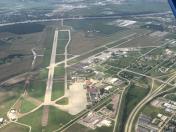
By: jbellwoo

By: anonymous


