Login
Register


0G3
Tecumseh Municipal Airport
Official FAA Data Effective 2026-01-22 0901Z
Chart Supplement

VFR Chart of 0G3
Sectional Charts at SkyVector.com
IFR Chart of 0G3
Enroute Charts at SkyVector.com
Location Information for 0G3
Coordinates: N40°24.06' / W96°10.23'Located 02 miles NE of Tecumseh, Nebraska on 183 acres of land. View all Airports in Nebraska.
Surveyed Elevation is 1306 feet MSL.
Operations Data
|
|
Airport Communications
| CTAF: | 122.900 |
|---|---|
| AWOS-3PT at AFK (18.7 NE): | 128.325 402-873-7375 |
| AWOS-3 at BIE (27.3 W): | 125.325 402-228-3229 |
| ASOS at FNB (32.9 SE): | 119.275 402-245-5948 |
- APCH/DEP SVC PRVDD BY MINNEAPOLIS ARTCC ON FREQS 126.4/317.7 (MARYSVILLE RCAG).
Nearby Navigation Aids
|
| ||||||||||||||||||||||||||||||||||||||||||||||||||||||||||||


Runway 15/33
| Dimensions: | 3501 x 75 feet / 1067 x 23 meters | |
|---|---|---|
| Surface: | Concrete in Excellent Condition | |
| Weight Limits: | S-6 | |
| Edge Lighting: | Medium Intensity | |
| Runway 15 | Runway 33 | |
| Coordinates: | N40°24.33' / W96°10.36' | N40°23.79' / W96°10.09' |
| Elevation: | 1305.2 | 1301.2 |
| Traffic Pattern: | Left | Left |
| Runway Heading: | 159° True | 339° True |
| Markings: | Non-Precision Instrument in good condition. | Non-Precision Instrument in good condition. |
| Glide Slope Indicator | P2L (3.00° Glide Path Angle) | P2L (3.00° Glide Path Angle) |
| REIL: | Yes | Yes |
Services Available
| Fuel: | 100LL (blue) |
|---|---|
| Transient Storage: | Hangars,Tiedowns |
| Airframe Repair: | NONE |
| Engine Repair: | NONE |
| Bottled Oxygen: | NONE |
| Bulk Oxygen: | NONE |
| Other Services: | PILOT INSTRUCTION |
Ownership Information
| Ownership: | Publicly owned | |
|---|---|---|
| Owner: | TECUMSEH AIRPORT AUTHORITY | PHIL JUILFS- CHAIRMAN. |
| P.O. BOX 837 | ||
| TECUMSEH, NE 68450-0837 | ||
| (402) 335-8338 | ||
| Manager: | MIKE WENDT | |
| PO BOX 537 | ||
| TECUMSEH, NE 68450-0537 | ||
| 402-335-3303 | ||
Other Remarks
- FOR CD CTC MINNEAPOLIS ARTCC AT 651-463-5588.
- COURTESY CAR AVBL.
- 0LL FUEL AVBL 24 HR WITH CREDIT CARD.
- ACTVT REIL RWY 15 & 33; MIRL RWY 15/33; PAPI RWY 15 & 33 - CTAF.
Weather Minimums

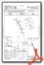
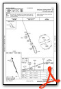
Instrument Approach Procedure (IAP) Charts
Nearby Airports with Instrument Procedures
| ID | Name | Heading / Distance | ||
|---|---|---|---|---|
 |
K01 | Farington Field Airport | 092° | 17.6 |
|
KAFK | Nebraska City Municipal Airport | 048° | 18.6 |
|
KBIE | Beatrice Municipal Airport | 257° | 27.4 |
|
KFNB | Brenner Field Airport | 125° | 32.9 |
|
KPMV | Plattsmouth Municipal/Douglas V Duey Field Airport | 019° | 34.8 |
|
K57 | Gould Peterson Municipal Airport | 085° | 36.9 |
|
KCEK | Crete Municipal Airport | 290° | 36.9 |
|
KLNK | Lincoln Airport | 315° | 38.1 |
|
KMYZ | Marysville Municipal Airport | 213° | 38.9 |
|
KSDA | Shenandoah Municipal Airport | 058° | 40.5 |
|
KOFF | Offutt AFB Airport | 015° | 44.7 |
|
KFBY | Fairbury Municipal Airport | 254° | 47.6 |
Airport Images
Do you have a recent image of this airport? Upload it here!


