Login
Register


CPF
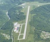
Wendell H Ford Airport
Official FAA Data Effective 2024-08-08 0901Z
Chart Supplement

VFR Chart of KCPF
Sectional Charts at SkyVector.com
IFR Chart of KCPF
Enroute Charts at SkyVector.com
Location Information for KCPF
Coordinates: N37°23.24' / W83°15.70'Located 10 miles NW of Hazard, Kentucky on 37 acres of land. View all Airports in Kentucky.
Surveyed Elevation is 1256 feet MSL.
Operations Data
|
|
Airport Communications
| AWOS-3: | 119.025 Tel. 606-435-2452 |
|---|---|
| UNICOM: | 122.700 |
| CTAF: | 122.700 |
| ASOS at JKL (12.7 N): | 118.375 606-666-2794 |
| AWOS-3 at I35 (32.1 S): | 118.35 606-573-9104 |
| AWOS-3PT at PBX (34.7 E): | 121.225 606-437-6701 |
- APCH/DEP SVC PRVDD BY INDIANAPOLIS ARTCC ON FREQS 126.575/257.850 (LYNCH RCAG).
Nearby Navigation Aids
|
| ||||||||||||||||||||||||||||||||||||||||||||||||||||||||||||


Runway 14/32
| Dimensions: | 5499 x 100 feet / 1676 x 30 meters | |
|---|---|---|
| Surface: | Asphalt in Good Condition | |
| Weight Limits: | 10 /F/C/X/T, S-30 | |
| Edge Lighting: | Medium Intensity | |
| Runway 14 | Runway 32 | |
| Coordinates: | N37°23.43' / W83°15.95' | N37°22.75' / W83°15.20' |
| Elevation: | 1243.4 | 1256.8 |
| Runway Heading: | 139° True | 319° True |
| Markings: | Non-Precision Instrument in good condition. | Non-Precision Instrument in good condition. |
| Glide Slope Indicator | P4L (3.00° Glide Path Angle) | P4L (4.00° Glide Path Angle) PAPIRWY 32 UNUSBL BYD 2.5 NM; PAPI RWY 32 UNUSBL BYD 7 DEGS RIGHT & BYD 5 DEGS LEFT OF CTNRLN. |
| REIL: | Yes | Yes |
| Obstacles: | 16 ft Hangar 640 ft from runway, 483 ft right of center | 239 ft Trees 4544 ft from runway, 755 ft left of center |
Runway 06/24
CLSD DLY SS-SR; BOTH RWY ENDS HAVE 300 FT DROP OFF. | ||
| Dimensions: | 3246 x 60 feet / 989 x 18 meters | |
|---|---|---|
| Surface: | Asphalt in Good Condition | |
| Weight Limits: | 10 /F/C/X/T, S-28, D-43 | |
| Runway 06 | Runway 24 | |
| Coordinates: | N37°23.37' / W83°16.19' | N37°23.64' / W83°15.61' |
| Elevation: | 1242.9 | 1243.2 |
| Runway Heading: | 59° True | 239° True |
| Displaced Threshold: | 200 Feet | 270 Feet |
| Markings: | Basic in good condition. | Basic in good condition. |
Services Available
| Fuel: | 100LL (blue), Jet A+ |
|---|---|
| Transient Storage: | Hangars,Tiedowns |
| Airframe Repair: | NOT AVAILABLE |
| Engine Repair: | NOT AVAILABLE |
| Bottled Oxygen: | NOT AVAILABLE |
| Bulk Oxygen: | NOT AVAILABLE |
| Other Services: | CHARTER SERVICE,PILOT INSTRUCTION,AIRCRAFT RENTAL |
Ownership Information
| Ownership: | Publicly owned | |
|---|---|---|
| Owner: | HAZARD-PERRY COUNTY BOARD | |
| P.O. BOX 2346 | ||
| HAZARD, KY 41702 | ||
| (606) 439-4518 | ||
| Manager: | JEFF HYLTON | |
| 1300 WENDELL H. FORD TERMINAL ROAD | ||
| CHAVIES, KY 41727 | ||
| (606) 233-5140 | ||
Operational Statistics
| Single Engine Aircraft Based on Field: | 11 | Statistics collected for 12 month period ending 2022-07-12 | |
|---|---|---|---|
| Multi-Engine Aircraft Based on Field: | 3 | Annual Commercial Operations: | none |
| Jet Aircraft Based on Field: | 3 | Annual Commuter Operations: | none |
| Helicopters Based on Field: | 1 | Annual Air Taxi Operations: | 1320 |
| Military Aircraft Based on Field: | none | Annual Military Operations: | 800 |
| Gliders Based on Field: | none | Annual GA Local Operations: | 3850 |
| Ultralights Based on Field: | none | Annual GA Itinerant Operations: | 4200 |
Other Remarks
- FOR CD CTC INDIANAPOLIS ARTCC AT 317-247-2411.
- ACTVT REIL RWY 14 & 32; PAPI RWY 14 & 32; MIRL RWY 14/32- CTAF.
Weather Minimums
Instrument Approach Procedure (IAP) Charts
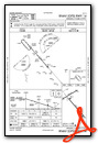
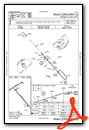
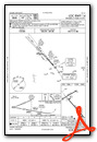
Nearby Airports with Instrument Procedures
| ID | Name | Heading / Distance | ||
|---|---|---|---|---|
 |
KJKL | Julian Carroll Airport | 347° | 12.7 |
|
I35 | Tucker-Guthrie Memorial Airport | 188° | 32.0 |
|
KPBX | Pike County/Hatcher Field Airport | 072° | 34.8 |
|
KSJS | Big Sandy Regional Airport | 053° | 36.9 |
|
KLNP | Lonesome Pine Airport | 124° | 42.5 |
|
KLOZ | London/Corbin/Magee Airport | 245° | 43.0 |
|
0VG | Lee County Airport | 177° | 44.0 |
|
1A6 | Middlesboro/Bell County Airport | 206° | 51.9 |
|
KSYM | Morehead-Rowan County Clyde A Thomas Regional Airport | 342° | 52.0 |
|
KIOB | Mount Sterling/Montgomery County Airport | 319° | 52.8 |
|
KRGA | Central Kentucky Regional Airport | 286° | 53.2 |
|
KEBD | Southern West Virginia Regional Airport | 071° | 57.2 |