Login
Register


LOZ
London/Corbin/Magee Airport
Official FAA Data Effective 2026-01-22 0901Z
Chart Supplement

VFR Chart of KLOZ
Sectional Charts at SkyVector.com
IFR Chart of KLOZ
Enroute Charts at SkyVector.com
Location Information for KLOZ
Coordinates: N37°5.21' / W84°4.64'Located 03 miles S of London, Kentucky on 186 acres of land. View all Airports in Kentucky.
Surveyed Elevation is 1212 feet MSL.
Operations Data
|
|
Airport Communications
| ASOS: | 119.075 Tel. 606-877-1699 |
|---|---|
| CTAF: | 123.000 |
| UNICOM: | 123.000 |
| AWOS-3 at BYL (18.5 S): | 119.575 606-549-1585 |
| AWOS-3 at SME (25.9 W): | 120.050 606-679-5710 |
| AWOS-3 at 1A6 (33.0 SE): | 119.425 606-248-3095 |
- APCH/DEP SVC PRVDD BY INDIANAPOLIS ARTCC ON FREQS 124.625/371.925 (LONDON 2 RCAG).
Nearby Navigation Aids
|
| ||||||||||||||||||||||||||||||||||||||||||||||||||||||||||||


Runway 06/24
TREES SW END OF RWY BOTH SIDES VIOLATES 7:1 TRSN SFC. | ||
| Dimensions: | 5750 x 150 feet / 1753 x 46 meters | |
|---|---|---|
| Surface: | Asphalt in Good Condition | |
| Weight Limits: | 23 /F/C/X/T, S-61, D-82, ST-151 | |
| Edge Lighting: | Medium Intensity | |
| Runway 06 | Runway 24 | |
| Coordinates: | N37°4.92' / W84°5.11' | N37°5.50' / W84°4.18' |
| Elevation: | 1212.3 | 1182.7 |
| Traffic Pattern: | Left | Left |
| Runway Heading: | 52° True | 232° True |
| Displaced Threshold: | 100 Feet | 548 Feet |
| Declared Distances: | TORA:5750 TODA:5750 ASDA:5100 LDA:5000 | TORA:5750 TODA:5750 ASDA:5750 LDA:5200 |
| Markings: | Precision Instrument in good condition. | Non-Precision Instrument in good condition. |
| Glide Slope Indicator | P4L (3.00° Glide Path Angle) | P4L (4.00° Glide Path Angle) |
| REIL: | Yes THR LGTS NON STD. | Yes THR LGTS NON STD. |
| Obstacles: | 61 ft Tree 900 ft from runway, 610 ft right of center APCH SLOPE 16:1 TO DTHR. |
29 ft Tree 292 ft from runway, 318 ft right of center |
Services Available
| Fuel: | 100LL (blue), Jet A+ |
|---|---|
| Transient Storage: | Hangars,Tiedowns |
| Airframe Repair: | MAJOR |
| Engine Repair: | MAJOR |
| Bottled Oxygen: | NOT AVAILABLE |
| Bulk Oxygen: | NOT AVAILABLE |
| Other Services: | AIR AMBULANCE SERVICES,CARGO HANDLING SERVICES,PILOT INSTRUCTION,AIRCRAFT RENTAL |
Ownership Information
| Ownership: | Publicly owned | |
|---|---|---|
| Owner: | CITIES OF LONDON & CORBIN | |
| 566 HAL ROGERS DRIVE | ||
| LONDON, KY 40744 | ||
| 606-878-9100 | ||
| Manager: | MATTHEW SINGER | |
| 566 HAL ROGERS DRIVE | ||
| LONDON, KY 40744 | ||
| 606-878-9100 | ||
Other Remarks
- FOR CD IF UNA TO CTC ON FSS FREQ, CTC INDIANAPOLIS ARTCC AT 317-247-2411.
- ACTVT REIL RWY 06 & 24; MIRL RWY 06/24 - CTAF. PAPI RWY 06 & 24 OPR CONSLY.
Weather Minimums


Instrument Approach Procedure (IAP) Charts
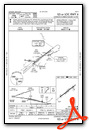
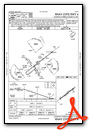
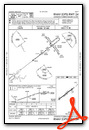
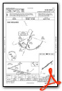
Nearby Airports with Instrument Procedures
| ID | Name | Heading / Distance | ||
|---|---|---|---|---|
 |
KBYL | Williamsburg-Whitley County Airport | 198° | 18.5 |
|
KSME | Lake Cumberland Regional Airport | 265° | 25.9 |
|
18I | Mc Creary County Airport | 212° | 27.9 |
|
1A6 | Middlesboro/Bell County Airport | 150° | 32.9 |
|
KRGA | Central Kentucky Regional Airport | 339° | 34.8 |
|
I35 | Tucker-Guthrie Memorial Airport | 111° | 37.2 |
|
KEKQ | Wayne County Airport | 249° | 39.9 |
|
KCPF | Wendell H Ford Airport | 065° | 43.0 |
|
KDVK | Stuart Powell Field Airport | 311° | 44.3 |
|
KSCX | Scott Municipal Airport | 213° | 45.1 |
|
KJAU | Colonel Tommy C Stiner Airfield Airport | 185° | 45.3 |
|
KJKL | Julian Carroll Airport | 049° | 47.4 |
Fuel Providers

Airport Images

By: Big Orange Bird


