Login
Register
1K7
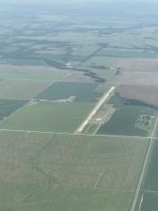
Fredonia Airport
Official FAA Data Effective 2026-01-22 0901Z
VFR Chart of 1K7
Sectional Charts at SkyVector.com
IFR Chart of 1K7
Enroute Charts at SkyVector.com
Location Information for 1K7
Coordinates: N37°34.84' / W95°50.23'Located 02 miles N of Fredonia, Kansas on 155 acres of land. View all Airports in Kansas.
Estimated Elevation is 882 feet MSL.
Operations Data
|
|
Airport Communications
| CTAF: | 122.900 |
|---|---|
| ASOS at CNU (17.6 E): | 127.075 620-431-6781 |
| ASOS at PPF (21.9 SE): | 118.175 620-336-3834 |
| AWOS-3PT at IDP (25.5 S): | 118.525 620-331-5980 |
Nearby Navigation Aids
|
| ||||||||||||||||||||||||||||||||||||||||||||||||||||||||||||
Runway 17/35
| Dimensions: | 4557 x 60 feet / 1389 x 18 meters | |
|---|---|---|
| Surface: | Concrete in Fair Condition | |
| Edge Lighting: | Low Intensity | |
| Runway 17 | Runway 35 | |
| Coordinates: | N37°35.22' / W95°50.23' | N37°34.47' / W95°50.23' |
| Elevation: | 882.0 | 877.0 |
| Runway Heading: | 180° True | 0 |
| Displaced Threshold: | 541 Feet | |
| Markings: | Non-Precision Instrument in fair condition. | Basic in fair condition. |
| Obstacles: | 35 ft Pole 524 ft from runway, 107 ft left of center | +15 FT ROAD 175 FT FM AER 35. |
Services Available
| Fuel: | NONE |
|---|---|
| Transient Storage: | Tiedowns |
| Airframe Repair: | NONE |
| Engine Repair: | NONE |
| Bottled Oxygen: | NONE |
| Bulk Oxygen: | NONE |
Ownership Information
| Ownership: | Publicly owned | |
|---|---|---|
| Owner: | CITY OF FREDONIA | |
| 100 N. 15TH STREET | ||
| FREDONIA, KS 66736 | ||
| 620-378-2231 | ||
| Manager: | KELLEY ZELLNER - CITY ADMINISTRATOR | SHANE GLOVER, STREETS SUPERINTENDENT IS CO-MANAGER OF AIRPORT FACILITY. |
| 100 N. 15TH STREET | ||
| FREDONIA, KS 66736 | ||
| 620-378-2231 | ||
Other Remarks
- WILDLIFE ON & INVOF ARPT.
- A DRAINAGE DITCH 70 FT LEFT OF AER 17 RUNS PARL 700 FT.
- FOR CD CTC KANSAS CITY ARTCC AT 913-254-8508.
- NSTD NPI MKGS. NO THLD BAR PRESENT.
- NSTD SMALL BSC MARKINGS
Nearby Airports with Instrument Procedures
| ID | Name | Heading / Distance | ||
|---|---|---|---|---|
 |
2K7 | Neodesha Municipal Airport | 133° | 12.6 |
 |
KCNU | Chanute Martin Johnson Airport | 072° | 17.5 |
 |
KPPF | Tri-City Airport | 133° | 21.8 |
 |
KIDP | Independence Municipal Airport | 173° | 25.5 |
 |
13K | Lt William M Milliken Airport | 306° | 27.1 |
 |
K88 | Allen County Airport | 051° | 27.5 |
 |
KCFV | Coffeyville Municipal Airport | 156° | 31.8 |
 |
KUKL | Coffey County Airport | 006° | 43.6 |
 |
KEMP | Emporia Municipal Airport | 339° | 48.0 |
 |
KEQA | El Dorado/Capt Jack Thomas Memorial Airport | 284° | 48.1 |
 |
KBVO | Bartlesville Municipal Airport | 189° | 49.7 |
 |
KFSK | Fort Scott Municipal Airport | 075° | 52.5 |


