Login
Register


2K7
Neodesha Municipal Airport
Official FAA Data Effective 2026-02-19 0901Z
Chart Supplement

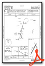
VFR Chart of 2K7
Sectional Charts at SkyVector.com
IFR Chart of 2K7
Enroute Charts at SkyVector.com
Location Information for 2K7
Coordinates: N37°26.12' / W95°38.77'Located 02 miles NE of Neodesha, Kansas on 190 acres of land. View all Airports in Kansas.
Surveyed Elevation is 841 feet MSL.
Operations Data
|
|
Airport Communications
| UNICOM: | 122.800 |
|---|---|
| CTAF: | 122.800 |
| ASOS at PPF (9.3 SE): | 118.175 620-336-3834 |
| ASOS at CNU (16.1 NE): | 127.075 620-431-6781 |
| AWOS-3PT at IDP (17.8 S): | 118.525 620-331-5980 |
- APCH/DEP CTL SVC PRVDD BY KANSAS CITY ARTCC (ZKC) ON FREQS 132.9/279.5 (CHANUTE RCAG).
Nearby Navigation Aids
|
| ||||||||||||||||||||||||||||||||||||||||||||||||||||||||||||


Runway 02/20
| Dimensions: | 2998 x 46 feet / 914 x 14 meters | |
|---|---|---|
| Surface: | Asphalt in Poor Condition MEDIUM/HIGH SEVERITY TRANSVERSE CRACKING LENGTH OF RWY 02/20. | |
| Weight Limits: | S-11 | |
| Edge Lighting: | Low Intensity NSTD LIRL; ALL CLEAR LENSES. | |
| Runway 02 | Runway 20 | |
| Coordinates: | N37°25.87' / W95°38.98' | N37°26.30' / W95°38.69' |
| Elevation: | 822.0 | 841.0 |
| Traffic Pattern: | Left | Left |
| Runway Heading: | 29° True | 209° True |
| Markings: | Basic in fair condition. | Basic in fair condition. |
| Obstacles: | 68 ft Trees 823 ft from runway, 106 ft right of center | + 5 FT FENCE POST 190 FT FM RWY 20; 96 FT RIGHT OF CL |
Runway 15/33
| Dimensions: | 2100 x 45 feet / 640 x 14 meters | |
|---|---|---|
| Surface: | Turf in Good Condition | |
| Runway 15 | Runway 33 | |
| Coordinates: | N37°26.34' / W95°38.76' | N37°26.02' / W95°38.58' |
| Elevation: | 840.0 | 825.0 |
| Runway Heading: | 156° True | 336° True |
| Markings: | in fair condition. | in fair condition. |
| Obstacles: | 35 ft Tree 440 ft from runway, 12 ft left of center | |
Services Available
| Fuel: | Automotive Gasoline |
|---|---|
| Transient Storage: | Tiedowns |
| Airframe Repair: | NONE |
| Engine Repair: | NONE |
| Bottled Oxygen: | NONE |
| Bulk Oxygen: | NONE |
Ownership Information
| Ownership: | Publicly owned | |
|---|---|---|
| Owner: | CITY OF NEODESHA | |
| PO BOX 336 | ||
| NEODESHA, KS 66757 | ||
| 620-325-2828 | ||
| Manager: | JEREMY JOHNSON | |
| PO BOX 336 | ||
| NEODESHA, KS 66757 | ||
| 620-288-9264 | EVENING CALL 620-920-0348 | |
Other Remarks
- THIS AIRPORT HAS BEEN SURVEYED BY THE NATIONAL GEODETIC SURVEY.
- ULTRALIGHT ACTIVITY ON AND INVOF ARPT.
- WILDLIFE ON & INVOF ARPT.
- FOR CD CTC KANSAS CITY ARTCC AT 913-254-8508.
- WHITE BARREL MARKERS ON BOTH ENDS.
Weather Minimums

Instrument Approach Procedure (IAP) Charts
Nearby Airports with Instrument Procedures
| ID | Name | Heading / Distance | ||
|---|---|---|---|---|
 |
KPPF | Tri-City Airport | 133° | 9.2 |
|
KCNU | Chanute Martin Johnson Airport | 028° | 15.9 |
|
KIDP | Independence Municipal Airport | 200° | 17.8 |
|
KCFV | Coffeyville Municipal Airport | 170° | 20.8 |
|
K88 | Allen County Airport | 025° | 28.7 |
|
13K | Lt William M Milliken Airport | 309° | 39.6 |
|
KPTS | Atkinson Municipal Airport | 088° | 43.7 |
|
KBVO | Bartlesville Municipal Airport | 203° | 43.9 |
|
KFSK | Fort Scott Municipal Airport | 062° | 47.1 |
|
KMIO | Miami Regional Airport | 130° | 48.1 |
|
KUKL | Coffey County Airport | 355° | 52.1 |
|
H04 | Vinita Municipal Airport | 154° | 54.6 |
Airport Images
Do you have a recent image of this airport? Upload it here!


