Login
Register


PPF
Tri-City Airport
Official FAA Data Effective 2026-01-22 0901Z
Chart Supplement

VFR Chart of KPPF
Sectional Charts at SkyVector.com
IFR Chart of KPPF
Enroute Charts at SkyVector.com
Location Information for KPPF
Coordinates: N37°19.85' / W95°30.37'Located 11 miles W of Parsons, Kansas on 802 acres of land. View all Airports in Kansas.
Surveyed Elevation is 900 feet MSL.
Operations Data
|
|
Airport Communications
| ASOS: | 118.175 Tel. 620-336-3834 |
|---|---|
| UNICOM: | 123.000 |
| CTAF: | 123.000 |
| ASOS at CFV (14.6 S): | 121.275 620-251-1959 |
| AWOS-3PT at IDP (16.7 SW): | 118.525 620-331-5980 |
| ASOS at CNU (20.4 N): | 127.075 620-431-6781 |
- APCH/DEP CTL SVC PRVDD BY KANSAS CITY ARTCC (ZKC) ON FREQS 128.6/282.325 (EDNA RCAG).
Nearby Navigation Aids
|
| ||||||||||||||||||||||||||||||||||||||||||||||||||||||||||||


Runway 17/35
| Dimensions: | 5001 x 75 feet / 1524 x 23 meters | |
|---|---|---|
| Surface: | Concrete in Excellent Condition | |
| Weight Limits: | S-25, D-45 | |
| Edge Lighting: | Medium Intensity | |
| Runway 17 | Runway 35 | |
| Coordinates: | N37°20.26' / W95°30.37' | N37°19.44' / W95°30.37' |
| Elevation: | 900.5 | 865.2 |
| Traffic Pattern: | Left | Left |
| Runway Heading: | 180° True | 360° True |
| Markings: | Non-Precision Instrument in good condition. | Non-Precision Instrument in good condition. |
| Glide Slope Indicator | V4L (3.00° Glide Path Angle) | V4L (3.00° Glide Path Angle) |
| REIL: | Yes | Yes |
| Obstacles: | 70 ft Tree 1680 ft from runway, 175 ft left of center CONTROLLING OBSTN EXCEEDS A 45 DEG SLP. |
250 ft Trees 20 ft from runway, 230 ft left of center 35 FT TREES, 40-199 FT DSTC, 237 FT L. |
Services Available
| Fuel: | 100LL (blue), Jet-A, Jet A+ |
|---|---|
| Transient Storage: | Hangars,Tiedowns |
| Airframe Repair: | NONE |
| Engine Repair: | NONE |
| Bottled Oxygen: | NONE |
| Bulk Oxygen: | NONE |
Ownership Information
| Ownership: | Publicly owned | |
|---|---|---|
| Owner: | CITY OF PARSONS | |
| MUNICIPAL BUILDING | ||
| PARSONS, KS 67357 | ||
| 620-421-7000 | ||
| Manager: | DYLAN VITT | |
| 163 24000 RD | ||
| CHERRYVALE, KS 67335 | ||
| 620-336-3440 | ||
Other Remarks
- WILDLIFE ON & INVOF RWYS.
- WKENDS AND HOLS, CALL OUT, NO CHARGE.
- FOR CD IF UNA TO CTC ON FSS FREQ, CTC KANSAS CITY ARTCC AT 913-254-8508.
- 0LL 24 HR SELF-SERVE 100LL FUEL.
- ACTVT VASI AND REIL RWYS 17 & 35 - CTAF. MIRL RWY 17/35 OPER DUSK-2300; AFT 2300 ACTVT - CTAF.
Weather Minimums

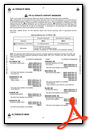
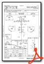
Instrument Approach Procedure (IAP) Charts

Nearby Airports with Instrument Procedures
| ID | Name | Heading / Distance | ||
|---|---|---|---|---|
 |
2K7 | Neodesha Municipal Airport | 313° | 9.2 |
|
KCFV | Coffeyville Municipal Airport | 192° | 14.5 |
|
KIDP | Independence Municipal Airport | 231° | 16.7 |
|
KCNU | Chanute Martin Johnson Airport | 002° | 20.2 |
|
K88 | Allen County Airport | 009° | 32.7 |
|
KPTS | Atkinson Municipal Airport | 078° | 37.7 |
|
KMIO | Miami Regional Airport | 130° | 39.0 |
|
KBVO | Bartlesville Municipal Airport | 215° | 41.8 |
|
KFSK | Fort Scott Municipal Airport | 051° | 45.0 |
|
H04 | Vinita Municipal Airport | 158° | 46.2 |
|
13K | Lt William M Milliken Airport | 310° | 48.8 |
|
KJLN | Joplin Regional Airport | 102° | 49.4 |
Airport Images
Do you have a recent image of this airport? Upload it here!


