Login
Register


EQA
El Dorado/Capt Jack Thomas Memorial Airport
Official FAA Data Effective 2025-11-27 0901Z
Chart Supplement

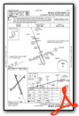
VFR Chart of KEQA
Sectional Charts at SkyVector.com
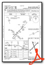
IFR Chart of KEQA
Enroute Charts at SkyVector.com
Location Information for KEQA
Coordinates: N37°46.45' / W96°49.06'Located 03 miles SE of El Dorado, Kansas on 220 acres of land. View all Airports in Kansas.
Surveyed Elevation is 1379 feet MSL.
Operations Data
|
|
Airport Communications
| AWOS-3P: | 120.875 Tel. 316-322-8095 |
|---|---|
| WICHITA APPROACH: | 134.8 269.1 |
| WICHITA DEPARTURE: | 134.8 269.1 |
| UNICOM: | 122.800 |
| CTAF: | 122.800 |
| AWOS-3P at 3AU (13.8 SW): | 124.175 316-733-6696 |
| AWOS-2 at 1K1 (14.0 W): | 118.3 316-530-6004 |
| ASOS at AAO (19.2 W): | 134.025 316-636-2541 |
Nearby Navigation Aids
|
| ||||||||||||||||||||||||||||||||||||||||||||||||||||||||||||


Runway 04/22
| Dimensions: | 4204 x 75 feet / 1281 x 23 meters | |
|---|---|---|
| Surface: | Asphalt in Fair Condition | |
| Weight Limits: | S-18, D-23 | |
| Edge Lighting: | High Intensity | |
| Runway 04 | Runway 22 | |
| Coordinates: | N37°46.21' / W96°49.39' | N37°46.72' / W96°48.79' |
| Elevation: | 1375.8 | 1378.2 |
| Traffic Pattern: | Left | Left |
| Runway Heading: | 43° True | 223° True |
| Markings: | Non-Precision Instrument in good condition. | Non-Precision Instrument in good condition. |
| Glide Slope Indicator | P2L (3.00° Glide Path Angle) | P2L (3.00° Glide Path Angle) |
| Obstacles: | 10 ft Trees 290 ft from runway, 175 ft left of center 15 FT TREES, 60-200 FT DSTC, 215 FT L. |
|
Runway 15/33
| Dimensions: | 4200 x 75 feet / 1280 x 23 meters | |
|---|---|---|
| Surface: | Concrete in Good Condition | |
| Weight Limits: | S-12, D-12 | |
| Edge Lighting: | High Intensity | |
| Runway 15 | Runway 33 | |
| Coordinates: | N37°46.75' / W96°49.20' | N37°46.11' / W96°48.88' |
| Elevation: | 1373.4 | 1379.3 |
| Runway Heading: | 159° True | 339° True |
| Markings: | Non-Precision Instrument in good condition. | Non-Precision Instrument in good condition. |
| Glide Slope Indicator | P2L (3.00° Glide Path Angle) | P2L (3.00° Glide Path Angle) |
| Obstacles: | 40 ft Trees 1160 ft from runway | |
Services Available
| Fuel: | 100LL (blue), Jet-A, Automotive Gasoline |
|---|---|
| Transient Storage: | Hangars,Tiedowns |
| Airframe Repair: | MAJOR |
| Engine Repair: | MAJOR |
| Bottled Oxygen: | NONE |
| Bulk Oxygen: | NONE |
| Other Services: | PILOT INSTRUCTION,AIRCRAFT RENTAL |
Ownership Information
| Ownership: | Publicly owned | |
|---|---|---|
| Owner: | CITY OF EL DORADO | |
| 220 E 1ST AVE | ||
| EL DORADO, KS 67042 | ||
| 316-321-9100 | ||
| Manager: | LARRY ARNOLD | |
| 220 E 1ST AVE | ||
| EL DORADO, KS 67042 | ||
| 316-321-1327 | ||
Other Remarks
- AVOID FLT OVR PRISON N OF ARPT.
- FOR CD CTC WICHITA APCH AT 316-350-1520.
- AFT HRS PHONE NMBR POSTED AT ARPT.
- COURTESY CAR.
- TERMINAL ACCESS AFT HRS CTAF.
- PHYS ADR 1485 S.E. 30TH.
- 0LL 100 LL, JET A, MOGAS 24 HR SELF-SERVE.
- ACTVT PAPI RWY 04 & 22, 15 & 33; HIRL 4/22 AND 15/33 - CTAF.
Weather Minimums

Instrument Approach Procedure (IAP) Charts


Nearby Airports with Instrument Procedures
| ID | Name | Heading / Distance | ||
|---|---|---|---|---|
 |
3AU | Augusta Municipal Airport | 243° | 13.9 |
|
1K1 | Lloyd Stearman Field Airport | 270° | 14.1 |
|
KAAO | Colonel James Jabara Airport | 265° | 19.3 |
|
KBEC | Beech Factory Airport | 255° | 19.5 |
|
K50 | Cook Airfield Airport | 233° | 21.1 |
|
KCEA | Cessna Acft Field Airport | 250° | 21.9 |
|
KIAB | Mc Connell AFB Airport | 247° | 23.3 |
|
13K | Lt William M Milliken Airport | 079° | 25.4 |
|
KEWK | Newton-City-County Airport | 308° | 27.6 |
|
KICT | Wichita Dwight D Eisenhower Ntl Airport | 255° | 30.2 |
|
KWLD | Strother Field Airport | 196° | 37.8 |
|
KEGT | Wellington Municipal Airport | 225° | 38.3 |
Airport Images
Do you have a recent image of this airport? Upload it here!


