Login
Register


1MT0
Nine Quarter Circle Ranch Airport
Official FAA Data Effective 2026-02-19 0901Z
VFR Chart of 1MT0
Sectional Charts at SkyVector.com
IFR Chart of 1MT0
Enroute Charts at SkyVector.com
Location Information for 1MT0
Coordinates: N45°4.05' / W111°17.83'Located 31 miles S of Gallatin Gateway, Montana. View all Airports in Montana.
Estimated Elevation is 6974 feet MSL.
Operations Data
|
|
Airport Communications
| UNICOM: | 122.800 |
|---|---|
| AWOS-3P at EKS (19.2 NW): | 119.85 406-682-3835 |
| AWOS-3P at WYS (24.0 S): | 118.1 (406) 646-7727 |
| ATIS at BZN (43.1 N): | 135.425 |
Nearby Navigation Aids
|
| ||||||||||||||||||||||||||||||||||||||||||


Runway 10/28
ONE WAY STRIP LAND E TO W REVERSE FOR TKOF. | ||
| Dimensions: | 4000 x 100 feet / 1219 x 30 meters | |
|---|---|---|
| Surface: | Turf | |
| Runway 10 | Runway 28 | |
| Traffic Pattern: | Right | Right |
| Obstacles: | ft Trees 2000 ft from runway | |
Services Available
| Fuel: | NONE |
|---|---|
| Transient Storage: | NONE |
| Airframe Repair: | NONE |
| Engine Repair: | NONE |
| Bottled Oxygen: | NOT AVAILABLE |
| Bulk Oxygen: | NOT AVAILABLE |
Ownership Information
| Ownership: | Privately Owned | |
|---|---|---|
| Owner: | KAMERON KELSEY | |
| 9 QUARTER CIRCLE RANCH | ||
| GALLATIN GATEWAY, MT 59730 | ||
| 406-995-4276 | ||
| Manager: | KAMERON KELSEY | |
| 9 QUARTER CIRCLE RANCH | ||
| GALLATIN GATEWAY, MT 59730 | ||
| 406-995-4276 | ||
Other Remarks
- FOR CD CTC SALT LAKE ARTCC AT 801-320-2568.
Nearby Airports with Instrument Procedures
| ID | Name | Heading / Distance | ||
|---|---|---|---|---|
 |
KEKS | Ennis Big Sky Airport | 310° | 19.5 |
|
KWYS | Yellowstone Airport | 161° | 24.0 |
|
KBZN | Bozeman Yellowstone International Airport | 008° | 43.0 |
|
KRVF | Ruby Valley Field Airport | 303° | 51.0 |
|
KLVM | Mission Field Airport | 043° | 52.2 |
|
KDLN | Dillon Airport | 282° | 54.5 |
|
6S0 | Big Timber At Howard Field Airport | 051° | 71.2 |
|
KBTM | Bert Mooney Airport | 316° | 73.5 |
|
KRXE | Rexburg-Madison County Airport | 196° | 77.2 |
|
KDIJ | Driggs/Reed Memorial Airport | 173° | 80.0 |
|
7S6 | White Sulphur Springs Airport | 010° | 87.2 |
|
KJAC | Jackson Hole Airport | 164° | 90.9 |
Airport Images
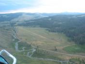
By: talbertson


