Login
Register


1R8
Bay Minette Municipal Airport
Official FAA Data Effective 2026-01-22 0901Z
Chart Supplement

VFR Chart of 1R8
Sectional Charts at SkyVector.com
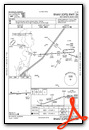
IFR Chart of 1R8
Enroute Charts at SkyVector.com
Location Information for 1R8
Coordinates: N30°52.22' / W87°49.16'Located 03 miles SW of Bay Minette, Alabama on 184 acres of land. View all Airports in Alabama.
Surveyed Elevation is 248 feet MSL.
Operations Data
|
|
Airport Communications
| AWOS-3PT: | 121.125 Tel. 251-580-5103 |
|---|---|
| MOBILE APPROACH: | 118.5 269.3 |
| MOBILE DEPARTURE: | 118.5 269.3 |
| CTAF: | 122.800 |
| UNICOM: | 122.800 |
| ATIS at BFM (19.5 SW): | 135.575 |
| ASOS at BFM (19.5 SW): | 251-431-6762 |
| ATIS at MOB (24.3 SW): | 124.75 |
- APCH/DEP SVC PRVDD BY HOUSTON ARTCC (ZHU) ON FREQS 127.65/285.475 (MOBILE RCAG) WHEN MOBILE APCH CTL (MOB) CLSD.
Nearby Navigation Aids
|
| ||||||||||||||||||||||||||||||||||||||||||||||||||||||||||||


Runway 08/26
| Dimensions: | 5500 x 79 feet / 1676 x 24 meters | |
|---|---|---|
| Surface: | Asphalt / Grooved in Good Condition | |
| Weight Limits: | S-28 | |
| Edge Lighting: | Medium Intensity | |
| Runway 08 | Runway 26 | |
| Coordinates: | N30°52.19' / W87°49.68' | N30°52.25' / W87°48.63' |
| Elevation: | 206.5 | 248.1 |
| Traffic Pattern: | Left | Left |
| Runway Heading: | 86° True | 266° True |
| Markings: | Non-Precision Instrument in fair condition. | Non-Precision Instrument in poor condition. |
| Glide Slope Indicator | P2L (3.50° Glide Path Angle) | P2L (3.00° Glide Path Angle) |
| REIL: | Yes | |
| Obstacles: | 113 ft Tree 2473 ft from runway, 268 ft right of center | 14 ft Brush 430 ft from runway, 75 ft right of center |
Services Available
| Fuel: | 100LL (blue), Jet A+ |
|---|---|
| Transient Storage: | Tiedowns |
| Airframe Repair: | MAJOR |
| Engine Repair: | MAJOR |
| Bottled Oxygen: | NONE |
| Bulk Oxygen: | NONE |
Ownership Information
| Ownership: | Publicly owned | |
|---|---|---|
| Owner: | CITY OF BAY MINETTE | |
| PO BOX 1208 | ||
| BAY MINETTE, AL 36507 | ||
| 251-580-1619 | ||
| Manager: | ASHLEY BOOTHE | |
| 11981 AIRPORT RD | ||
| BAY MINETTE, AL 36507 | ||
| 251-937-2900 | ||
Other Remarks
- FOR CD CTC MOBILE APCH AT 251-662-6236, WHEN APCH CLSD CTC HOUSTON ARTCC AT 281-230-5622.
- RWY ID AND TD MRKGS SEVERELY FADED
- 0LL 100LL FUEL 24 HR SELF SVC AVBL.
- JET A+ FUEL SVC AVBL 0800-1700 CALL 251-937-2900.
- ACTVT PAPI RWY 08 & 26; MIRL RWY 08/26 - CTAF.
Weather Minimums

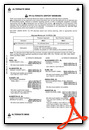
Instrument Approach Procedure (IAP) Charts

Nearby Airports with Instrument Procedures
| ID | Name | Heading / Distance | ||
|---|---|---|---|---|
 |
KBFM | Mobile International Airport | 221° | 19.4 |
|
0R1 | Atmore Municipal Airport | 065° | 21.1 |
|
KMOB | Mobile Regional Airport | 244° | 24.4 |
|
KCQF | H L Sonny Callahan Airport | 186° | 24.7 |
|
5R4 | Holk Field At Foley Municipal Airport | 166° | 27.2 |
|
2R5 | St Elmo Airport | 227° | 32.3 |
|
KJKA | Gulf Shores International/Jack Edwards Field Airport | 167° | 35.6 |
|
4R3 | Jackson Municipal Airport | 353° | 36.1 |
|
5R1 | Roy Wilcox Airport | 331° | 39.8 |
|
12J | Brewton Municipal Airport | 074° | 40.3 |
|
KNPA | Pensacola NAS (Forrest Sherman Field) Airport | 139° | 40.4 |
|
KPNS | Pensacola International Airport | 125° | 40.5 |
Airport Images
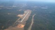
By: victirby


