Login
Register


2E8
Cackleberry Airport
Official FAA Data Effective 2026-02-19 0901Z
Chart Supplement

VFR Chart of 2E8
Sectional Charts at SkyVector.com
IFR Chart of 2E8
Enroute Charts at SkyVector.com
Location Information for 2E8
Coordinates: N42°25.51' / W83°52.11'Located 05 miles N of Dexter, Michigan on 40 acres of land. View all Airports in Michigan.
Estimated Elevation is 898 feet MSL.
Operations Data
|
|
Airport Communications
| CTAF: | 122.900 |
|---|---|
| ASOS at ARB (13.3 SE): | 734-668-7173 |
| ATIS at ARB (13.3 SE): | 134.55 |
| AWOS-3P at OZW (13.5 N): | 118.875 517-546-4450 |
Nearby Navigation Aids
|
| ||||||||||||||||||||||||||||||||||||||||||||||||||||||||||||


Runway 06/24
CLSD WHEN SNOW COVD. | ||
| Dimensions: | 2113 x 100 feet / 644 x 30 meters | |
|---|---|---|
| Surface: | Turf in Good Condition | |
| Runway 06 | Runway 24 | |
| Coordinates: | N42°25.39' / W83°52.29' | N42°25.62' / W83°51.94' |
| Elevation: | 886.0 | 898.0 |
| Traffic Pattern: | Left | Left |
| Runway Heading: | 49° True | 229° True |
| Displaced Threshold: | 515 Feet | 500 Feet |
| Obstacles: | 29 ft Trees 222 ft from runway, 50 ft left of center APCH RATIO 9:1 TO DTHR OVR +69 FT TREE, 646 FT DIST, 140 FT L. |
47 ft Tree 57 ft from runway, 55 ft right of center APCH RATIO 0:1 TO DTHR OVR +73 FT TREE, 0 FT DIST, 71 FT L. |
Services Available
| Fuel: | NONE |
|---|---|
| Transient Storage: | Tiedowns |
| Airframe Repair: | NOT AVAILABLE |
| Engine Repair: | NOT AVAILABLE |
| Bottled Oxygen: | NOT AVAILABLE |
| Bulk Oxygen: | NOT AVAILABLE |
Ownership Information
| Ownership: | Privately Owned | |
|---|---|---|
| Owner: | ANNA WILTSE | |
| 7150 STRAWBERRY LAKE RD | ||
| DEXTER, MI 48130-9306 | ||
| 734-426-4493 | ||
| Manager: | STEPHANIE KLAWENDER | |
| 7150 STRAWBERRY LAKE RD | ||
| DEXTER, MI 48130-9306 | ||
| 734-678-7942 | ||
Other Remarks
- FOR RWY CONDS CALL AMGR.
- FOR CD CTC DETROIT APCH AT 734-955-1404.
- DEER & LRG BIRDS ON & INVOF ARPT.
- RWY & DTHR MKD WITH 3 FT YELLOW CONES.
- 3 FT YELLOW CONES; DTHR MKD WITH 3 FT WIDE GND LVL CONC STONES.
Nearby Airports with Instrument Procedures
| ID | Name | Heading / Distance | ||
|---|---|---|---|---|
 |
Y47 | Oakland Southwest Airport | 066° | 11.8 |
|
KOZW | Livingston County/Spencer J Hardy Airport | 337° | 13.3 |
|
KARB | Ann Arbor Municipal Airport | 155° | 13.3 |
|
KYIP | Willow Run Airport | 126° | 18.7 |
|
1D2 | Canton-Plymouth-Mettetal Airport | 104° | 18.9 |
|
9G2 | Prices Airport | 010° | 23.4 |
|
KPTK | Oakland County International Airport | 053° | 24.6 |
|
KTEW | Mason Jewett Field Airport | 289° | 26.0 |
|
KDTW | Detroit Metro Wayne County Airport | 118° | 26.2 |
|
KJXN | Jackson County/Reynolds Field Airport | 249° | 28.2 |
|
KVLL | Oakland/Troy Airport | 076° | 31.5 |
|
KFNT | Bishop International Airport | 009° | 32.9 |
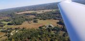
Airport Images

By: bentmettle
By: 15zenderb


