Login
Register


ESF
Esler Regional Airport
Official FAA Data Effective 2026-01-22 0901Z
Chart Supplement

VFR Chart of KESF
Sectional Charts at SkyVector.com
IFR Chart of KESF
Enroute Charts at SkyVector.com
Location Information for KESF
Coordinates: N31°23.69' / W92°17.75'Located 10 miles NE of Alexandria, Louisiana on 2161 acres of land. View all Airports in Louisiana.
Surveyed Elevation is 111 feet MSL.
Operations Data
|
|
Airport Communications
| ASOS: | 119.425 Tel. 318-484-9031 |
|---|---|
| POLK APPROACH: | 125.4 254.8 |
| POLK DEPARTURE: | 125.4 254.8 |
| CTAF: | 122.800 |
| UNICOM: | 122.800 |
| ASOS at AEX (13.9 W): | 123.975 318-442-6583 |
| AWOS-3PT at MKV (21.4 SE): | 124.175 318-409-4120 |
| AWOS-3 at 0R4 (41.5 E): | 118.2 318-336-8028 |
Nearby Navigation Aids
|
| ||||||||||||||||||||||||||||||||||||||||||||||||||||||||||||


Runway 09/27
| Dimensions: | 5998 x 150 feet / 1828 x 46 meters | |
|---|---|---|
| Surface: | Asphalt / Grooved in Good Condition | |
| Weight Limits: | S-75, D-150, ST-220 | |
| Edge Lighting: | High Intensity | |
| Runway 09 | Runway 27 | |
| Coordinates: | N31°23.67' / W92°18.36' | N31°23.65' / W92°17.21' |
| Elevation: | 96.2 | 89.4 |
| Traffic Pattern: | Left | Left |
| Runway Heading: | 91° True | 271° True |
| Markings: | Precision Instrument in good condition. | Precision Instrument in good condition. |
| Glide Slope Indicator | P4L (3.00° Glide Path Angle) | |
| Approach Lights: | MALSR 1,400 Foot Medium-intensity Approach Lighting System with runway alignment indicator lights. | |
| REIL: | Yes RWY 09 REILS OTS | RWY 09 REILS OTS |
| Obstacles: | 82 ft Trees 3080 ft from runway | |
Runway 14/32
| Dimensions: | 5600 x 150 feet / 1707 x 46 meters | |
|---|---|---|
| Surface: | Asphalt / Grooved in Fair Condition | |
| Weight Limits: | S-75, D-150, ST-220 | |
| Edge Lighting: | Medium Intensity | |
| Runway 14 | Runway 32 | |
| Coordinates: | N31°24.11' / W92°18.02' | N31°23.35' / W92°17.40' |
| Elevation: | 111.6 | 87.7 |
| Traffic Pattern: | Left | Left |
| Runway Heading: | 145° True | 325° True |
| Markings: | Precision Instrument in poor condition. | Precision Instrument in poor condition. |
| Glide Slope Indicator | P4L (3.00° Glide Path Angle) RWY 14 PAPI OTS | P4L (3.00° Glide Path Angle) |
| REIL: | Yes RWY 14 REIL OTS | Yes RWY 14 REIL OTS |
| Obstacles: | 116 ft Trees 2056 ft from runway | 5 ft Fence 185 ft from runway FENCE 100 FT 0B AND SMALL TREE 14 FT TALL 232 FT FM END OF RY. |
Services Available
| Fuel: | 100LL (blue), Jet-A |
|---|---|
| Transient Storage: | Tiedowns |
| Airframe Repair: | NOT AVAILABLE |
| Engine Repair: | NOT AVAILABLE |
| Bottled Oxygen: | NOT AVAILABLE |
| Bulk Oxygen: | NOT AVAILABLE |
Ownership Information
| Ownership: | Publicly owned | |
|---|---|---|
| Owner: | RAPIDES PARISH POLICE JURY | |
| PO BOX 1150 | ||
| ALEXANDRIA, LA 71309 | ||
| 318-767-2536 | ||
| Manager: | LOUIS BUSBY | |
| 7625 ESLER FIELD RD | ||
| PINEVILLE, LA 71360 | ||
| 985-750-0485 | ||
Other Remarks
- BIRDS ON & INVOF ARPT SEASONALLY.
- PAEW ADJ RYS & TWYS.
- FOR CD CTC POLK APCH AT 337-531-2352.
- PL 85-204/SPECIAL ACT OF CONGRESS
- RWY MARKINGS SEVERELY FADED
- RWY MARKINGS SEVERELY FADED
- 0LL FUEL AVBL TUE-FRI 0700-1700; SAT-MON ON CALL IN ADVANCE CALL 318-443-5566. 100LL SELF SERVE 24HRS
- ACTVT MALSR RWY 27; REIL RWY 09, 14/32; MIRL RWY 14/32; HIRL RWY 9/27; TWY LGTS TWYS A, B, C, D & E - CTAF.
Weather Minimums
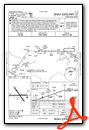
Instrument Approach Procedure (IAP) Charts
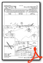
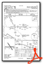
Nearby Airports with Instrument Procedures
| ID | Name | Heading / Distance | ||
|---|---|---|---|---|
 |
KAEX | Alexandria International Airport | 252° | 13.6 |
|
KMKV | Marksville Municipal Airport | 146° | 21.4 |
|
2R6 | Bunkie Municipal Airport | 173° | 26.4 |
|
0R5 | David G Joyce Airport | 331° | 38.8 |
|
0R4 | Concordia Parish Airport | 075° | 41.7 |
|
KACP | Allen Parish Airport | 207° | 43.6 |
|
KIER | Natchitoches Regional Airport | 296° | 46.0 |
|
KOPL | St Landry Parish Airport | 168° | 51.1 |
|
KHEZ | Hardy-Anders Field/Natchez-Adams County Airport | 075° | 52.9 |
|
F88 | Jonesboro Airport | 335° | 53.2 |
|
L39 | Leesville Airport | 256° | 55.5 |
|
4R7 | Eunice Airport | 186° | 56.0 |
Airport Images
Do you have a recent image of this airport? Upload it here!


Comments
Self Serve 100LL
Self serve 100LL is out on the ramp away from the main building. Cool helicopters and the main runway is in great shape.
No restroom services when the
No restroom services when the college adjacent to the 100LL self serve pump is clsoed.