Login
Register
3FL0
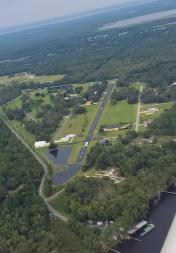
Mount Royal Airport
Official FAA Data Effective 2026-01-22 0901Z
VFR Chart of 3FL0
Sectional Charts at SkyVector.com
IFR Chart of 3FL0
Enroute Charts at SkyVector.com
Location Information for 3FL0
Coordinates: N29°26.16' / W81°39.40'Located 03 miles S of Welaka, Florida on 7 acres of land. View all Airports in Florida.
Estimated Elevation is 60 feet MSL.
Operations Data
|
|
Airport Communications
| AWOS-3 at 28J (13.5 N): | 119.925 386-312-2212 |
|---|---|
| AWOS-3 at FIN (23.5 E): | 128.325 386-437-7334 |
| ATIS at FIN (23.5 E): | 128.325 |
Nearby Navigation Aids
|
| ||||||||||||||||||||||||||||||||||||||||||
Runway 08/26
| Dimensions: | 3000 x 50 feet / 914 x 15 meters | |
|---|---|---|
| Surface: | Asphalt in Good Condition | |
| Edge Lighting: | Medium Intensity | |
| Runway 08 | Runway 26 | |
| Traffic Pattern: | Left | |
| Displaced Threshold: | 500 Feet | |
| Obstacles: | 50 ft Trees 300 ft from runway | |
Runway 11W/29W
| Dimensions: | 2430 x 50 feet / 741 x 15 meters | |
|---|---|---|
| Surface: | Water | |
| Runway 11W | Runway 29W | |
| Coordinates: | N29°25.89' / W81°39.94' | N29°25.75' / W81°39.51' |
| Elevation: | 0.0 | 0.0 |
| Traffic Pattern: | Right | |
Ownership Information
| Ownership: | Privately Owned | |
|---|---|---|
| Owner: | MRAPPOA | MRAPPOA - MT ROYAL AIRPARK PROPERTY OWNERS ASSOC. |
| 109 AIRPORT DRIVE | ||
| CRESCENT CITY, FL 32112 | ||
| 407-427-5558 | ||
| Manager: | KEVIN POSTON | |
| 454 TIMUCUAN TRAIL | EMAIL ADDRESS: SPARUSA1@GMAIL.COM | |
| CRESCENT CITY, FL 32112 | ||
| 407-427-5558 | ||
Other Remarks
- CTAF 123.15
- FOR CD CTC JACKSONVILLE APCH AT 904-741-0284.
- BIRDS, DEER & OTR ANIMALS ON AND INVOF ARPT.
Nearby Airports with Instrument Procedures
| ID | Name | Heading / Distance | ||
|---|---|---|---|---|
 |
28J | Palatka Municipal/Lt Kay Larkin Field Airport | 352° | 13.4 |
 |
KFIN | Flagler Exec Airport | 085° | 23.6 |
 |
KOMN | Ormond Beach Municipal Airport | 105° | 29.6 |
 |
KDED | Deland Municipal-Sidney H Taylor Field Airport | 138° | 29.5 |
 |
X23 | Umatilla Municipal Airport | 179° | 30.6 |
 |
42J | Keystone Heights Airport | 320° | 31.9 |
 |
KOCF | Ocala International-Jim Taylor Field Airport | 242° | 33.7 |
 |
KDAB | Daytona Beach International Airport | 115° | 34.9 |
 |
KSGJ | St Augustine Airport | 027° | 35.4 |
 |
KGNV | Gainesville Regional Airport | 295° | 35.6 |
 |
KLEE | Leesburg International Airport | 192° | 37.6 |
 |
7FL6 | Spruce Creek Airport | 123° | 38.5 |


