Login
Register


42J
Keystone Heights Airport
Official FAA Data Effective 2026-02-19 0901Z
Chart Supplement

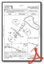
Airport Diagram

VFR Chart of 42J
Sectional Charts at SkyVector.com
IFR Chart of 42J
Enroute Charts at SkyVector.com
Location Information for 42J
Coordinates: N29°50.68' / W82°2.85'Located 03 miles N of Keystone Heights, Florida on 2476 acres of land. View all Airports in Florida.
Surveyed Elevation is 195 feet MSL.
Operations Data
|
|
Airport Communications
| AWOS-3: | 124.275 Tel. 352-473-8273 |
|---|---|
| JACKSONVILLE APPROACH: | 118.175 ;10000 FT & BLW 338.25 |
| JACKSONVILLE DEPARTURE: | 118.175 ;10000 FT & BLW 338.25 |
| UNICOM: | 122.700 |
| CTAF: | 122.700 |
| ATIS at GNV (14.9 SW): | 127.15 |
| ASOS at GNV (14.9 SW): | 127.15 352-335-8672 |
| AWOS-3 at 28J (21.8 SE): | 119.925 386-312-2212 |
Nearby Navigation Aids
|
| ||||||||||||||||||||||||||||||||||||||||||||||||||||||


Runway 05/23
| Dimensions: | 5046 x 100 feet / 1538 x 30 meters | |
|---|---|---|
| Surface: | Asphalt in Fair Condition | |
| Weight Limits: | 15 /R/B/X/T, S-40, D-80 | |
| Edge Lighting: | Medium Intensity | |
| Runway 05 | Runway 23 | |
| Coordinates: | N29°50.19' / W82°3.12' | N29°50.78' / W82°2.45' |
| Elevation: | 176.4 | 195.8 |
| Traffic Pattern: | Right | Left |
| Runway Heading: | 45° True | 225° True |
| Markings: | Non-Precision Instrument in fair condition. | Non-Precision Instrument in fair condition. |
| Glide Slope Indicator | P2L (3.00° Glide Path Angle) | P2L (3.00° Glide Path Angle) |
| REIL: | Yes | Yes |
| Obstacles: | 49 ft Trees 1840 ft from runway, 220 ft right of center | 39 ft Trees 1175 ft from runway, 235 ft left of center |
Runway 11/29
| Dimensions: | 4899 x 75 feet / 1493 x 23 meters | |
|---|---|---|
| Surface: | Asphalt in Fair Condition | |
| Weight Limits: | 14 /R/C/X/T, S-30, D-60 | |
| Edge Lighting: | Medium Intensity | |
| Runway 11 | Runway 29 | |
| Coordinates: | N29°50.99' / W82°3.37' | N29°50.78' / W82°2.47' |
| Elevation: | 185.5 | 195.7 |
| Traffic Pattern: | Left | Right |
| Runway Heading: | 105° True | 285° True |
| Markings: | Basic in fair condition. | Basic in fair condition. |
| Glide Slope Indicator | P2L (3.00° Glide Path Angle) | P2L (3.00° Glide Path Angle) |
| REIL: | Yes | |
| Obstacles: | 40 ft Trees 1200 ft from runway | 48 ft Trees 1160 ft from runway, 100 ft right of center |
Services Available
| Fuel: | 100LL (blue), Jet A+ |
|---|---|
| Transient Storage: | Tiedowns |
| Airframe Repair: | MAJOR |
| Engine Repair: | MAJOR |
| Bottled Oxygen: | NONE |
| Bulk Oxygen: | NONE |
| Other Services: | CHARTER SERVICE,PILOT INSTRUCTION,AIRCRAFT RENTAL |
Ownership Information
| Ownership: | Publicly owned | |
|---|---|---|
| Owner: | KEYSTONE AIRPORT AUTHORITY | |
| 7150 AIRPORT ROAD | ||
| STARKE, FL 32091-9347 | ||
| 352-473-0031 | ||
| Manager: | CRAIG COON | |
| 7150 AIRPORT RD, 7150 AIRPORT ROAD | ||
| STARKE, FL 32091-9347 | ||
| 352-473-0031 | ||
Other Remarks
- ANIMALS ON AND INVOF ARPT.
- RSTRD AREA 2903A 1.5 NM RWY 23 END. FLY R TFC TO AVOID.
- RWYS 11/29 RSTRD BY AMGR TO ACFT 12500 LBS GWT OR LESS.
- SELF SERVE AVGAS AVBL 24 HRS WITH CREDIT CARD. JET A BY APPOINTMENT. CALL 352-473-0031.
- RWY 5/23 WEIGHT BEARING CAPACITY 2S-155.
- FOR CD CTC JACKSONVILLE APCH AT 904-741-0284.
- SS-SR ACTVT REIL RWY 05, 23, & 11; MIRL RWY 05/23 & 11/29 - CTAF. PAPI OPR CONSLY.
Weather Minimums
Instrument Approach Procedure (IAP) Charts
Nearby Airports with Instrument Procedures
| ID | Name | Heading / Distance | ||
|---|---|---|---|---|
 |
KGNV | Gainesville Regional Airport | 231° | 14.9 |
|
28J | Palatka Municipal/Lt Kay Larkin Field Airport | 120° | 21.8 |
|
KVQQ | Cecil Airport | 021° | 24.1 |
|
KHEG | Herlong Recreational Airport | 025° | 28.8 |
|
KNIP | Jacksonville NAS (Towers Field) Airport | 039° | 30.3 |
|
KLCQ | Lake City Gateway Airport | 306° | 34.2 |
|
X60 | Williston Regional Airport | 217° | 36.7 |
|
KSGJ | St Augustine Airport | 079° | 37.5 |
|
KCRG | Jacksonville Exec At Craig Airport | 043° | 40.4 |
|
KOCF | Ocala International-Jim Taylor Field Airport | 192° | 41.3 |
|
KJAX | Jacksonville International Airport | 025° | 43.1 |
|
KNRB | Mayport Ns (Adm David L Mcdonald Field) Airport | 044° | 46.1 |
Airport Images
Do you have a recent image of this airport? Upload it here!


