Login
Register


HYI
San Marcos Regional Airport
Official FAA Data Effective 2025-11-27 0901Z
Chart Supplement

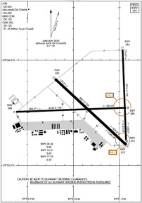
KHYI Airport Diagram
VFR Chart of KHYI
Sectional Charts at SkyVector.com
IFR Chart of KHYI
Enroute Charts at SkyVector.com
Location Information for KHYI
Coordinates: N29°53.56' / W97°51.78'Located 31 miles S of Austin, Texas on 1303 acres of land. View all Airports in Texas.
Surveyed Elevation is 594 feet MSL.
Operations Data
|
|
Airport Communications
| ATIS: | 120.825 (512-353-8005) |
|---|---|
| AWOS-3PT: | Tel. 512-353-8005 |
| SAN MARCOS TOWER: | 126.825 |
| SAN MARCOS GROUND: | 120.125 |
| AUSTIN APPROACH: | 119.0 370.85 |
| AUSTIN DEPARTURE: | 119.0 370.85 |
| CLEARANCE DELIVERY: | 120.125 121.35 ;WHEN HYI TWR CLSD |
| CTAF: | 126.825 |
| BNDIA DP: | 119.0 370.85 |
| POTRR STAR: | 127.225 317.65 |
| SZAGI STAR: | 118.15 ;SFC-7000 FT 119.0 ;8,000-12,000 FT 350.25 ;SFC-7000 FT 370.85 ;8,000-12,000 FT |
| SAYBR DP: | 119.0 370.85 |
| ELOEL DP: | 119.0 370.85 |
| ILEXY DP: | 119.0 370.85 |
| GABOO STAR: | 127.225 317.65 |
| MUCKY DP: | 119.0 370.85 |
| AEROZ DP: | 119.0 370.85 |
| BLEWE STAR: | 127.225 317.65 |
| ATIS at BAZ (14.6 SW): | 119.325 |
| ASOS at BAZ (14.6 SW): | 119.325 830-629-7979 |
| D-ATIS at AUS (20.7 NE): | 124.4 |
Nearby Navigation Aids
|
| ||||||||||||||||||||||||||||||||||||||||||||||||||||||||||||


Runway 08/26
| Dimensions: | 6330 x 100 feet / 1929 x 30 meters | |
|---|---|---|
| Surface: | Asphalt in Good Condition | |
| Weight Limits: | S-80 | |
| Edge Lighting: | Medium Intensity | |
| Runway 08 | Runway 26 | |
| Coordinates: | N29°53.51' / W97°52.62' | N29°53.55' / W97°51.43' |
| Elevation: | 587.8 | 580.0 |
| Traffic Pattern: | Left | Left |
| Runway Heading: | 88° True | 268° True |
| Markings: | Non-Precision Instrument in fair condition. | Non-Precision Instrument in fair condition. |
| Obstacles: | 6 ft Fence 201 ft from runway, 360 ft left of center 6 FT FENCE 130-199 FT DSTC, 360 FT L. |
8 ft Crops 205 ft from runway |
Runway 13/31
| Dimensions: | 5601 x 100 feet / 1707 x 30 meters | |
|---|---|---|
| Surface: | Asphalt in Good Condition | |
| Weight Limits: | S-60 | |
| Edge Lighting: | Medium Intensity | |
| Runway 13 | Runway 31 | |
| Coordinates: | N29°53.82' / W97°52.20' | N29°53.19' / W97°51.42' |
| Elevation: | 593.1 | 573.4 |
| Traffic Pattern: | Left | Left |
| Runway Heading: | 133° True | 313° True |
| Markings: | Precision Instrument in good condition. | Precision Instrument in good condition. |
| Glide Slope Indicator | P2L (3.00° Glide Path Angle) | P2L (3.00° Glide Path Angle) |
| Approach Lights: | MALS 1,400 Foot Medium-intensity Approach Lighting System. | |
| Obstacles: | 64 ft Trees 2200 ft from runway | |
Runway 17/35
| Dimensions: | 5214 x 100 feet / 1589 x 30 meters | |
|---|---|---|
| Surface: | Asphalt in Good Condition | |
| Weight Limits: | S-20 | |
| Edge Lighting: | Medium Intensity | |
| Runway 17 | Runway 35 | |
| Coordinates: | N29°54.10' / W97°51.47' | N29°53.24' / W97°51.43' |
| Elevation: | 594.5 | 575.0 |
| Traffic Pattern: | Left | Left |
| Runway Heading: | 178° True | 358° True |
| Markings: | Non-Precision Instrument in fair condition. | Non-Precision Instrument in fair condition. |
| Glide Slope Indicator | P2L (3.00° Glide Path Angle) | |
Services Available
| Fuel: | 100LL (blue), Jet-A |
|---|---|
| Transient Storage: | Hangars,Tiedowns |
| Airframe Repair: | MAJOR |
| Engine Repair: | NOT AVAILABLE |
| Bottled Oxygen: | LOW |
| Bulk Oxygen: | LOW |
| Other Services: | AVIONICS,CHARTER SERVICE,PILOT INSTRUCTION,AIRCRAFT RENTAL,AIRCRAFT SALES |
Ownership Information
| Ownership: | Publicly owned | |
|---|---|---|
| Owner: | CITY OF SAN MARCOS | |
| 630 E. HOPKINS STREET | ||
| SAN MARCOS, TX 78666 | ||
| 512-216-6039 | ||
| Manager: | CASSIDY BERENATO | CASSIDY BERENATO |
| 4400 HWY 21, SUITE 200 | ||
| SAN MARCOS, TX 78666 | ||
| 512-216-6039 | EMERG CTC: CITY OF SAN MARCOS POLICE DISPATCH - 512-753-2108 | |
Other Remarks
- FOR CD CTC AUSTIN APCH AT 512-369-7865.
- APN ALL IREG SFC.
- BIRDS AND WILDLIFE ON AND INVOF ARPT.
- 0LL 100LL SELF SVC; 100 LL & JET A AVBL FULL SERVE.
- ACTVT MALS RWY 13; MIRL RWYS 08/26, 13/31 & 17/35 PRESET LOW INTST, TO INCR INTST - CTAF. PAPI RWYS 13, 31, 17 OPR CONSLY.
Weather Minimums

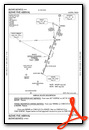
Standard Terminal Arrival (STAR) Charts


Instrument Approach Procedure (IAP) Charts


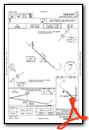
Departure Procedure (DP) Charts


Nearby Airports with Instrument Procedures
| ID | Name | Heading / Distance | ||
|---|---|---|---|---|
 |
50R | Lockhart Municipal Airport | 104° | 10.3 |
|
KBAZ | New Braunfels Ntl Airport | 220° | 14.6 |
|
KAUS | Austin-Bergstrom International Airport | 029° | 20.7 |
|
3R9 | Lakeway Airpark Airport | 346° | 28.6 |
|
KRND | Randolph AFB Airport | 224° | 30.7 |
|
KEDC | Austin Exec Airport | 026° | 33.9 |
|
KRYW | Lago Vista Tx/Rusty Allen Airport | 351° | 36.7 |
|
84R | Smithville Crawford Municipal Airport | 077° | 37.2 |
|
KSAT | San Antonio International Airport | 236° | 38.3 |
|
5C1 | Boerne Stage Airfield Airport | 257° | 44.6 |
|
KSSF | Stinson Municipal Airport | 223° | 46.0 |
|
T74 | Taylor Municipal Airport | 028° | 46.2 |
Airport Images

By: SV Jenn


