



Login
Register
4AK
Livengood Camp Airport
Official FAA Data Effective 2026-10-01 0901Z
Chart Supplement

VFR Chart of 4AK
Sectional Charts at SkyVector.com
IFR Chart of 4AK
Enroute Charts at SkyVector.com
Location Information for 4AK
Coordinates: N65°28.04' / W148°39.22'Located 00 miles E of Livengood, Alaska. View all Airports in Alaska.
Estimated Elevation is 427 feet MSL.
Operations Data
|
|
Airport Communications
| CTAF: | 122.900 |
|---|---|
| ATIS at FAI (44.0 SE): | 124.4 |
| ASOS at FAI (44.0 SE): | 124.4 907-621-7609 |
| ATIS at FBK (46.0 SE): | 134.25 |
- APCH/DEP SVC PRVDD BY ANCHORAGE ARTCC (ZAN) ON FREQS 120.9/319.2 (MURPHY DOME RCAG).
Nearby Navigation Aids
|
| ||||||||||||||||||||||||||||||||||||||||||


Runway 15/33
| Dimensions: | 3000 x 50 feet / 914 x 15 meters | |
|---|---|---|
| Surface: | Gravel in Good Condition | |
| Runway 15 | Runway 33 | |
| Coordinates: | N65°28.28' / W148°39.30' | N65°27.79' / W148°39.15' |
| Elevation: | 431.9 | 422.9 |
| Traffic Pattern: | Left | Left |
| Markings: | Non-Standard | Non-Standard |
| Obstacles: | 7 ft Trees 10 ft from runway, 124 ft left of center | 18 ft Trees 12 ft from runway, 122 ft right of center |
Services Available
| Fuel: | NONE |
|---|---|
| Transient Storage: | NONE |
| Airframe Repair: | NONE |
| Engine Repair: | NONE |
| Bottled Oxygen: | NONE |
| Bulk Oxygen: | NONE |
Ownership Information
| Ownership: | Publicly owned | |
|---|---|---|
| Owner: | ALASKA DOT&PF NORTHERN REGION | |
| 2301 PEGER RD | ||
| FAIRBANKS, AK 99709 | ||
| 907-451-2200 | ||
| Manager: | JEFF RUSSELL | |
| 2301 PEGER RD | ||
| FAIRBANKS, AK 99709 | ||
| 907-451-2207 | ||
Other Remarks
- RY NOT MAINTAINED & CONDITION NOT MONITORED, RECOMMEND VISUAL INSPECTION PRIOR TO LANDING.
- WX CAMERA AVBL ON INTERNET AT HTTPS://WEATHERCAMS.FAA.GOV
- BE ALERT: -WATCH FOR FREQUENT HELICOPTER TRAFFIC FROM ADJACENT WORK CAMP.
- RYS 15 & 33 NSTD MKGS; RY EDGES MKD WITH CONES.
Nearby Airports with Instrument Procedures
| ID | Name | Heading / Distance | ||
|---|---|---|---|---|
 |
PAFA | Fairbanks International Airport | 152° | 44.1 |
|
PANN | Nenana Municipal Airport | 191° | 56.4 |
|
PAML | Manley Hot Springs Airport | 241° | 58.0 |
|
PAWB | Beaver Airport | 029° | 62.0 |
|
PAEI | Eielson AFB Airport | 140° | 62.3 |
|
PAHV | Healy River Airport | 184° | 96.6 |
|
PAVE | Venetie Airport | 029° | 108.2 |
|
PABT | Bettles Airport | 322° | 111.7 |
|
PACX | Coldfoot Airport | 341° | 113.8 |
|
PABI | Allen AAF Airport | 138° | 116.4 |
Airport Images
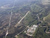
By: rcombellick

By: rcombellick



