Login
Register


5G7
Bluffton Airport
Official FAA Data Effective 2026-01-22 0901Z
Chart Supplement

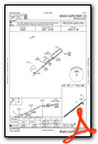
VFR Chart of 5G7
Sectional Charts at SkyVector.com
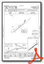
IFR Chart of 5G7
Enroute Charts at SkyVector.com
Location Information for 5G7
Coordinates: N40°53.13' / W83°52.12'Located 01 miles SE of Bluffton, Ohio on 100 acres of land. View all Airports in Ohio.
Surveyed Elevation is 850 feet MSL.
Operations Data
|
|
Airport Communications
| TOLEDO APPROACH: | 120.8 317.55 |
|---|---|
| TOLEDO DEPARTURE: | 120.8 317.55 |
| CTAF: | 122.800 |
| UNICOM: | 122.800 |
| AWOS-3 at OWX (10.4 NW): | 120.525 419-523-4151 |
| ASOS at FDY (11.9 NE): | 132.85 419-427-8524 |
| ASOS at AOH (12.9 SW): | 128.725 419-224-6098 |
Nearby Navigation Aids
|
| ||||||||||||||||||||||||||||||||||||||||||||||||||||||||||||


Runway 05/23
| Dimensions: | 4126 x 75 feet / 1258 x 23 meters | |
|---|---|---|
| Surface: | Asphalt in Fair Condition | |
| Weight Limits: | S-12 | |
| Edge Lighting: | Medium Intensity | |
| Runway 05 | Runway 23 | |
| Coordinates: | N40°52.92' / W83°52.47' | N40°53.34' / W83°51.77' |
| Elevation: | 850.6 | 846.7 |
| Traffic Pattern: | Left | Left |
| Runway Heading: | 52° True | 232° True |
| Markings: | Non-Precision Instrument in fair condition. | Non-Precision Instrument in fair condition. |
| Glide Slope Indicator | P4L (3.00° Glide Path Angle) PAPI UNUSBL BYD 9 DEGS RIGHT OF CNTRLN. | |
| REIL: | Yes | Yes |
| Obstacles: | 53 ft Trees 633 ft from runway, 125 ft left of center | |
Services Available
| Fuel: | 100LL (blue), Jet-A |
|---|---|
| Transient Storage: | Hangars,Tiedowns |
| Airframe Repair: | MAJOR |
| Engine Repair: | MAJOR |
| Bottled Oxygen: | NONE |
| Bulk Oxygen: | NONE |
| Other Services: | AIR AMBULANCE SERVICES,AVIONICS,PILOT INSTRUCTION,AIRCRAFT RENTAL,AIRCRAFT SALES |
Ownership Information
| Ownership: | Publicly owned | |
|---|---|---|
| Owner: | VILLAGE OF BLUFFTON | |
| PO BOX 63 | ||
| BLUFFTON, OH 45817-0063 | ||
| 419-358-2066 | ||
| Manager: | NICK VANCE | |
| 1080 NAVAJO DR | ||
| BLUFFTON, OH 45817-9691 | ||
| 419-358-7045 | ||
Other Remarks
- FOR CD CTC TOLEDO APCH AT 419-865-1495.
- DEER & BIRDS ON & INVOF ARPT.
- ACTVT REIL RWY 05 & 23; PAPI RWY 23; MIRL RWY 05/23 - CTAF.
- UNICOM MNT IREGLY.
Weather Minimums

Instrument Approach Procedure (IAP) Charts
Nearby Airports with Instrument Procedures
| ID | Name | Heading / Distance | ||
|---|---|---|---|---|
 |
KOWX | Putnam County Airport | 330° | 10.4 |
|
KFDY | Findlay Airport | 050° | 11.8 |
|
KAOH | Lima Allen County Airport | 214° | 12.9 |
|
I95 | Hardin County Airport | 148° | 19.4 |
|
56D | Wyandot County Airport | 090° | 25.2 |
|
KFZI | Donald P Miller Airport | 049° | 28.3 |
|
KAXV | Neil Armstrong Airport | 219° | 30.6 |
|
7W5 | Henry County Airport | 342° | 30.7 |
|
KEDJ | Bellefontaine Regional Airport | 175° | 30.9 |
|
1G0 | Wood County Airport | 019° | 32.2 |
|
16G | Seneca County Airport | 067° | 32.3 |
|
KVNW | Van Wert County Airport | 268° | 33.7 |
Airport Images
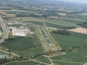
By: btracy62


