Login
Register


1G0
Wood County Airport
Official FAA Data Effective 2026-02-19 0901Z
Chart Supplement

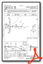
VFR Chart of 1G0
Sectional Charts at SkyVector.com
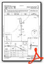
IFR Chart of 1G0
Enroute Charts at SkyVector.com
Location Information for 1G0
Coordinates: N41°23.46' / W83°37.81'Located 01 miles NE of Bowling Green, Ohio on 240 acres of land. View all Airports in Ohio.
Surveyed Elevation is 673 feet MSL.
Operations Data
|
|
Airport Communications
| AWOS-3: | 120.725 Tel. 419-354-1415 |
|---|---|
| TOLEDO APPROACH: | 126.1 317.55 |
| TOLEDO DEPARTURE: | 126.1 317.55 |
| CLEARANCE DELIVERY: | 125.6 |
| UNICOM: | 122.975 |
| CTAF: | 122.975 |
| ASOS at TDZ (12.4 NE): | 121.575 419-838-5034 |
| ASOS at TOL (14.2 NW): | 419-210-1094 |
| ATIS at TOL (14.2 NW): | 118.75 |
Nearby Navigation Aids
|
| ||||||||||||||||||||||||||||||||||||||||||||||||||||||||||||


Runway 10/28
| Dimensions: | 4199 x 75 feet / 1280 x 23 meters | |
|---|---|---|
| Surface: | Asphalt in Good Condition | |
| Edge Lighting: | Medium Intensity | |
| Runway 10 | Runway 28 | |
| Coordinates: | N41°23.51' / W83°38.11' | N41°23.50' / W83°37.20' |
| Elevation: | 671.5 | 671.6 |
| Traffic Pattern: | Right | |
| Runway Heading: | 91° True | 271° True |
| Markings: | Non-Precision Instrument in good condition. | Non-Precision Instrument in good condition. |
| Glide Slope Indicator | P2L (3.00° Glide Path Angle) | P2L (3.00° Glide Path Angle) |
| REIL: | Yes | Yes |
| Obstacles: | 3 ft Crops 201 ft from runway, 165 ft right of center OBSTN CLNC SLP 0:1 DUE TO +3 FT CROPS/CULTIVATED FLD, 201 FT DIST, 165 FT R & 230 FT L. OBSTN CLNC SLP 0:1 DUE TO +3 FT CROPS/CULTIVATED FLD, 75-200 FT DIST, 165 FT R. |
3 ft Crops 201 ft from runway, 150 ft right of center OBSTN CLNC SLP 0:1 DUE TO +3 FT CROPS/CULTIVATED FLD, 201 FT DIST, 150 FT L/R. OBSTN CLNC SLP 0:1 DUE TO +3 FT CROPS/CULTIVATED FLD, 0-200 FT DIST, 150 FT R; 145-200 FT DIST, 150 FT R. |
Runway 18/36
| Dimensions: | 2628 x 50 feet / 801 x 15 meters | |
|---|---|---|
| Surface: | Asphalt in Good Condition | |
| Edge Lighting: | Medium Intensity | |
| Runway 18 | Runway 36 | |
| Coordinates: | N41°23.61' / W83°38.06' | N41°23.17' / W83°38.05' |
| Elevation: | 671.4 | 671.4 |
| Traffic Pattern: | Left | Right |
| Runway Heading: | 179° True | 359° True |
| Displaced Threshold: | 68 Feet | |
| Markings: | Non-Precision Instrument in good condition. | Non-Precision Instrument in good condition. |
| Glide Slope Indicator | P4L (3.00° Glide Path Angle) | |
| REIL: | Yes | |
| Obstacles: | 3 ft Crops 201 ft from runway, 140 ft right of center OBSTN CLNC SLP 0:1 DUE TO +3 FT CROPS/CULTIVATED FLD, 201 FT DIST, 140 FT L & 150 FT R. OBSTN CLNC SLP 0:1 DUE TO +3 FT CROPS/CULTIVATED FLD, 0-200 FT DIST, 140 FT L & 150 FT R. |
16 ft Road 270 ft from runway, 260 ft right of center OBSTN CLNC SLP 4:1 TO THR DUE TO +16 FT ROAD, 270 FT DIST, 260 FT L/R; 20:1 TO DTHR. OBSTN CLNC SLP 0:1 DUE TO +3 FT CROPS/CULTIVATED FLD, 0-200 FT DIST, 140 FT R. |
Services Available
| Fuel: | 100LL (blue), Jet-A |
|---|---|
| Transient Storage: | Hangars,Tiedowns PRIOR CDN RQRD FOR HNGR. |
| Airframe Repair: | NOT AVAILABLE |
| Engine Repair: | NOT AVAILABLE |
| Bottled Oxygen: | NOT AVAILABLE |
| Bulk Oxygen: | NOT AVAILABLE |
| Other Services: | PILOT INSTRUCTION |
Ownership Information
| Ownership: | Publicly owned | |
|---|---|---|
| Owner: | WOOD CO ARPT AUTH | |
| 1261 E POE RD | ||
| BOWLING GREEN, OH 43402-9392 | ||
| 419-354-2908 | ||
| Manager: | PATRICK OREM | MGR@DACOR.NET. |
| 1261 E POE RD | ||
| BOWLING GREEN, OH 43402-9392 | ||
| 419-354-2908 | OR 419-654-6623. | |
Other Remarks
- OCCNL BIRDS AND OTHER WILDLIFE ON & INVOF ARPT
- 160 FT AGL STADIUM LGTS .6 NM SE OF ARPT.
- FOR CD CTC TOLEDO APCH AT 419-865-1495
- CALM WIND RWY.
- ANTI-ICING AVBL AT NOZZLE.
- ACTVT MIRL RWYS 10/28 & 18/36; REIL RWY 10, 18 & 28 PAPI RWY 18 - CTAF.
Weather Minimums

Instrument Approach Procedure (IAP) Charts
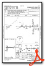

Nearby Airports with Instrument Procedures
| ID | Name | Heading / Distance | ||
|---|---|---|---|---|
 |
KTDZ | Toledo Exec Airport | 032° | 12.4 |
|
KTOL | Eugene F Kranz Toledo Express Airport | 325° | 14.2 |
|
KFZI | Donald P Miller Airport | 138° | 16.1 |
|
7W5 | Henry County Airport | 267° | 19.8 |
|
KDUH | Toledo Suburban Airport | 356° | 20.7 |
|
14G | Fremont Airport | 099° | 21.5 |
|
KFDY | Findlay Airport | 184° | 22.8 |
|
KUSE | Fulton County Airport | 300° | 26.0 |
|
16G | Seneca County Airport | 133° | 26.0 |
|
KOWX | Putnam County Airport | 216° | 26.6 |
|
S24 | Sandusky County Regional Airport | 101° | 27.4 |
|
5G7 | Bluffton Airport | 199° | 32.2 |
Airport Images

By: Big Orange Bird


