Login
Register


16G
Seneca County Airport
Official FAA Data Effective 2026-01-22 0901Z
Chart Supplement

VFR Chart of 16G
Sectional Charts at SkyVector.com
IFR Chart of 16G
Enroute Charts at SkyVector.com
Location Information for 16G
Coordinates: N41°5.64' / W83°12.75'Located 02 miles SW of Tiffin, Ohio on 132 acres of land. View all Airports in Ohio.
Surveyed Elevation is 785 feet MSL.
Operations Data
|
|
Airport Communications
| AWOS-3: | 127.175 Tel. 419-443-1043 |
|---|---|
| TOLEDO APPROACH: | 120.8 317.55 |
| TOLEDO DEPARTURE: | 120.8 317.55 |
| UNICOM: | 123.000 |
| CTAF: | 123.000 |
| AWOS-3 at FZI (10.0 NW): | 124.625 419-436-0053 |
| AWOS-3P at S24 (14.5 NE): | 119.575 419-547-6932 |
| ASOS at FDY (21.2 W): | 132.85 419-427-8524 |
Nearby Navigation Aids
|
| ||||||||||||||||||||||||||||||||||||||||||||||||||||||||||||


Runway 06/24
| Dimensions: | 4000 x 75 feet / 1219 x 23 meters | |
|---|---|---|
| Surface: | Asphalt in Good Condition | |
| Edge Lighting: | Medium Intensity | |
| Runway 06 | Runway 24 | |
| Coordinates: | N41°5.46' / W83°13.11' | N41°5.82' / W83°12.39' |
| Elevation: | 785.9 | 781.1 |
| Traffic Pattern: | Left | Left |
| Runway Heading: | 56° True | 236° True |
| Markings: | Non-Precision Instrument in good condition. | Non-Precision Instrument in good condition. |
| Glide Slope Indicator | P4L (3.00° Glide Path Angle) PAPI UNUSBL BYD 5 DEGS LEFT OF CNTRLN. | P4L (3.00° Glide Path Angle) PAPI UNUSBL BYD 4 DEGS LEFT & 8 DEGS RIGHT OF CNTRLN |
| REIL: | Yes | Yes |
| Obstacles: | 70 ft Trees 612 ft from runway, 289 ft left of center | |
Services Available
| Fuel: | 100LL (blue), Jet A+ |
|---|---|
| Transient Storage: | Hangars,Tiedowns |
| Airframe Repair: | MAJOR |
| Engine Repair: | MAJOR |
| Bottled Oxygen: | HIGH |
| Bulk Oxygen: | HIGH/LOW |
| Other Services: | PILOT INSTRUCTION,AIRCRAFT RENTAL,AIRCRAFT SALES |
Ownership Information
| Ownership: | Publicly owned | |
|---|---|---|
| Owner: | SENECA COUNTY COMMISSIONERS | |
| 81 JEFFERSON ST | ||
| TIFFIN, OH 44883 | ||
| 419-447-4550 | ||
| Manager: | ANDREW NEWMAN | |
| 1778 W US HIGHWAY 224 | ||
| TIFFIN, OH 44883-8820 | ||
| 419-447-1550 | ||
Other Remarks
- THIS AIRPORT HAS BEEN SURVEYED BY THE NATIONAL GEODETIC SURVEY.
- FOR CD CTC TOLEDO APCH AT 419-865-1495.
- 0LL 100LL & JET A+ AVBL AFT HRS & HOLS SELF SVC VIA CREDIT CARD.
- ACTVT REIL RWY 06 & 24; PAPI RWY 06 & 24; MIRL RWY 06/24 - CTAF.
Weather Minimums

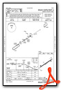
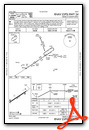
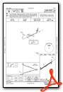
Instrument Approach Procedure (IAP) Charts

Nearby Airports with Instrument Procedures
| ID | Name | Heading / Distance | ||
|---|---|---|---|---|
 |
KFZI | Donald P Miller Airport | 305° | 10.0 |
|
56D | Wyandot County Airport | 200° | 13.5 |
|
S24 | Sandusky County Regional Airport | 033° | 14.5 |
|
14G | Fremont Airport | 009° | 14.5 |
|
KFDY | Findlay Airport | 256° | 21.3 |
|
17G | Port Bucyrus/Crawford County Airport | 149° | 21.6 |
|
8G1 | Willard Airport | 098° | 22.4 |
|
1G0 | Wood County Airport | 313° | 26.0 |
|
12G | Shelby Community Airport | 119° | 26.9 |
|
KMNN | Marion Municipal Airport | 166° | 29.4 |
|
KPCW | Erie-Ottawa International Airport | 031° | 29.7 |
|
KGQQ | Galion Municipal Airport | 132° | 30.2 |
Airport Images
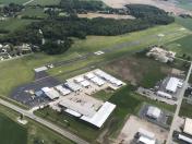
By: btracy62


