Login
Register


5L0
Lakota Municipal Airport
Official FAA Data Effective 2025-11-27 0901Z
Chart Supplement

VFR Chart of 5L0
Sectional Charts at SkyVector.com
IFR Chart of 5L0
Enroute Charts at SkyVector.com
Location Information for 5L0
Coordinates: N48°1.74' / W98°19.54'Located 01 miles SE of Lakota, North Dakota on 186 acres of land. View all Airports in North Dakota.
Surveyed Elevation is 1511 feet MSL.
Operations Data
|
|
Airport Communications
| CTAF: | 122.800 |
|---|---|
| UNICOM: | 122.800 |
| AWOS-3PT at DVL (23.7 W): | 125.875 701-662-7214 |
| D-ATIS at RDR (37.4 E): | 273.45 |
| AWOS-3 at S32 (37.5 S): | 118.750 701-797-2566 |
- APCH/DEP SVC PRVDD BY MINNEAPOLIS ARTCC (ZMP) ON 132.15/269.6 (GRAND FORKS RCAG).
Nearby Navigation Aids
|
| ||||||||||||||||||||||||||||||||||||||||||


Runway 15/33
| Dimensions: | 3500 x 60 feet / 1067 x 18 meters | |
|---|---|---|
| Surface: | Asphalt in Fair Condition | |
| Weight Limits: | S-12 | |
| Edge Lighting: | Medium Intensity | |
| Runway 15 | Runway 33 | |
| Coordinates: | N48°2.01' / W98°19.66' | N48°1.46' / W98°19.43' |
| Elevation: | 1511.2 | 1507.1 |
| Traffic Pattern: | Left | Left |
| Runway Heading: | 165° True | 345° True |
| Markings: | Non-Precision Instrument in poor condition. | Non-Precision Instrument in poor condition. |
| Glide Slope Indicator | P2L (3.00° Glide Path Angle) | P2L (3.00° Glide Path Angle) |
Services Available
| Fuel: | 100LL (blue) |
|---|---|
| Transient Storage: | Hangars,Tiedowns |
| Airframe Repair: | NONE |
| Engine Repair: | NONE |
| Bottled Oxygen: | NONE |
| Bulk Oxygen: | NONE |
| Other Services: | CROP DUSTING SERVICES |
Ownership Information
| Ownership: | Publicly owned | |
|---|---|---|
| Owner: | LAKOTA ARPT AUTHORITY | CHAIRMAN OF ARPT AUTH; DOUG MANBECK 701-247-2400. |
| BOX 505 | ||
| LAKOTA, ND 58344 | ||
| (701) 247-2561 | ||
| Manager: | MATT NELSON | |
| BOX 505 | ||
| LAKOTA, ND 58344 | ||
| 713-320-4770 | ||
Other Remarks
- CONFIRM SNOW REMOVAL & WINTER COND WITH CITY SUPT 701-304-0127/247-3112.
- 32 FT PLINE MARKED WITH ORANGE BALLS 1/2 NM FROM RWY 33 THLD ON CTRLN.
- FOR CD CTC MINNEAPOLIS ARTCC AT 651-463-5588.
- BIRDS ON & INVOF ARPT.
- RWY MKGS FADED & WORN.
- RWY MKGS FADED & WORN.
- 0LL SELF SVC FUEL AVBL H24 VIA CREDIT CARD.
- RY 15/33 MIRL AND PAPI OPER DUSK -0000 AFT HRS CTAF 122.8 TO ACTVT.
Weather Minimums

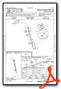
Instrument Approach Procedure (IAP) Charts
Nearby Airports with Instrument Procedures
| ID | Name | Heading / Distance | ||
|---|---|---|---|---|
 |
KDVL | Devils Lake Regional Airport | 282° | 24.1 |
|
4V4 | Northwood Municipal/Vince Field Airport | 121° | 34.9 |
|
KRDR | Grand Forks AFB Airport | 095° | 37.5 |
|
S32 | Cooperstown Municipal Airport | 166° | 37.5 |
|
D55 | Robertson Field Airport | 356° | 43.6 |
|
KGAF | Hutson Field Airport | 059° | 44.5 |
|
9D7 | Cando Municipal Airport | 306° | 45.5 |
|
KGFK | Grand Forks International Airport | 095° | 46.6 |
|
46D | Carrington Municipal Airport | 224° | 48.2 |
|
2C8 | Cavalier Municipal Airport | 031° | 53.1 |
|
96D | Walhalla Municipal Airport | 016° | 57.3 |
|
3H4 | Hillsboro Municipal Airport | 127° | 65.2 |
Airport Images
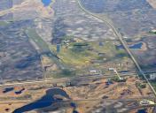
By: winglet714

By: winglet714


