Login
Register


FDW
Fairfield County Airport
Official FAA Data Effective 2026-02-19 0901Z
Chart Supplement

VFR Chart of KFDW
Sectional Charts at SkyVector.com
IFR Chart of KFDW
Enroute Charts at SkyVector.com
Location Information for KFDW
Coordinates: N34°18.94' / W81°6.51'Located 03 miles SW of Winnsboro, South Carolina on 159 acres of land. View all Airports in South Carolina.
Surveyed Elevation is 577 feet MSL.
Operations Data
|
|
Airport Communications
| AWOS-3: | 119.075 Tel. 803-712-2577 |
|---|---|
| COLUMBIA APPROACH: | 133.4 285.6 |
| COLUMBIA DEPARTURE: | 133.4 285.6 |
| CTAF: | 123.050 |
| UNICOM: | 123.050 |
| ASOS at CUB (21.5 S): | 118.675 803-929-0665 |
| ASOS at CAE (22.4 S): | 803-369-6879 |
| ATIS at CAE (22.6 S): | 120.15 |
Nearby Navigation Aids
|
| ||||||||||||||||||||||||||||||||||||||||||||||||||||||||||||


Runway 04/22
| Dimensions: | 5243 x 100 feet / 1598 x 30 meters | |
|---|---|---|
| Surface: | Asphalt in Excellent Condition | |
| Weight Limits: | S-42, D-60 | |
| Edge Lighting: | Medium Intensity | |
| Runway 04 | Runway 22 | |
| Coordinates: | N34°18.60' / W81°6.84' | N34°19.28' / W81°6.19' |
| Elevation: | 577.5 | 559.1 |
| Traffic Pattern: | Left | Left |
| Runway Heading: | 38° True | 218° True |
| Displaced Threshold: | 233 Feet | |
| Markings: | Non-Precision Instrument in good condition. | Non-Precision Instrument in good condition. |
| Glide Slope Indicator | P4L (3.00° Glide Path Angle) | P4L (3.00° Glide Path Angle) |
| Obstacles: | 19 ft Tree 479 ft from runway, 166 ft right of center | 80 ft Tree 2820 ft from runway, 297 ft right of center |
Services Available
| Fuel: | 100LL (blue), Jet-A |
|---|---|
| Transient Storage: | Tiedowns |
| Airframe Repair: | MAJOR |
| Engine Repair: | MAJOR |
| Bottled Oxygen: | NONE |
| Bulk Oxygen: | NONE |
| Other Services: | AVIONICS,PILOT INSTRUCTION,AIRCRAFT RENTAL |
Ownership Information
| Ownership: | Publicly owned | |
|---|---|---|
| Owner: | FAIRFIELD COUNTY | |
| PO BOX 216 | ||
| WINNSBORO, SC 29180 | ||
| (803) 635-1058 | ||
| Manager: | DENISE BRYAN | |
| 1291 RUNWAY RD | ||
| WINNSBORO, SC 29180 | ||
| (803) 718-0087 | ||
Other Remarks
- TPA 1400 MSL.
- FOR CD CTC COLUMBIA APCH AT 803-822-5242 OR 803-822-5040.
- (CONTACT TITLE) FOR FBO CALL (803) 635-3086.
- ACTVT MIRL RY 04/22 & PAPI RYS 04 & 22 - CTAF.
Weather Minimums

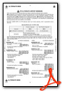
Instrument Approach Procedure (IAP) Charts

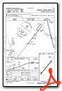
Nearby Airports with Instrument Procedures
| ID | Name | Heading / Distance | ||
|---|---|---|---|---|
 |
KCUB | Jim Hamilton L B Owens Airport | 164° | 21.4 |
|
KCAE | Columbia Metro Airport | 181° | 22.6 |
|
KEOE | Newberry County Airport | 269° | 26.4 |
|
KCDN | Woodward Field Airport | 093° | 27.1 |
|
KLKR | Lancaster County-Mc Whirter Field Airport | 027° | 27.4 |
|
KMMT | Mc Entire Jngb Airport | 146° | 28.2 |
|
KDCM | Chester Catawba Regional Airport | 351° | 28.7 |
|
6J0 | Lexington County Airport | 192° | 32.0 |
|
35A | Union County, Troy Shelton Field Airport | 310° | 34.5 |
|
N52 | Jaars-Townsend Airport | 028° | 37.4 |
|
KSSC | Shaw AFB Airport | 122° | 37.8 |
|
KUZA | Rock Hill/York County/Bryant Field Airport | 003° | 40.3 |
Airport Images
Do you have a recent image of this airport? Upload it here!


