Login
Register
6S9
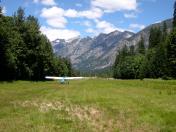
Stehekin State Airport
Official FAA Data Effective 2026-02-19 0901Z
VFR Chart of 6S9
Sectional Charts at SkyVector.com
IFR Chart of 6S9
Enroute Charts at SkyVector.com
Location Information for 6S9
Coordinates: N48°20.75' / W120°43.25'Located 03 miles NW of Stehekin, Washington. View all Airports in Washington.
Estimated Elevation is 1230 feet MSL.
Operations Data
|
|
Airport Communications
| CTAF: | 122.900 |
|---|---|
| AWOS-3 at S52 (23.3 E): | 118.425 509-997-0142 |
| ASOS at OMK (48.3 E): | 118.325 509-826-2655 |
| AWOS-3PT at AWO (58.6 W): | 135.625 360-435-8045 |
Nearby Navigation Aids
|
| ||||||||||||||||||||||||||||||||||||||||||||||||
Runway 13/31
| Dimensions: | 2630 x 100 feet / 802 x 30 meters | |
|---|---|---|
| Surface: | Turf in Fair Condition | |
| Runway 13 | Runway 31 | |
| Coordinates: | N48°20.94' / W120°43.40' | N48°20.56' / W120°43.09' |
| Elevation: | 1230.0 | 1190.0 |
| Traffic Pattern: | Left | Left |
| Runway Heading: | 152° True | 332° True |
| Obstacles: | 10 ft Road 150 ft from runway | 84 ft Trees 1006 ft from runway |
Services Available
| Fuel: | NONE |
|---|---|
| Transient Storage: | Tiedowns PILOTS PROVD OWN TIEDOWN CHAINS. |
| Airframe Repair: | NONE |
| Engine Repair: | NONE |
| Bottled Oxygen: | NONE |
| Bulk Oxygen: | NONE |
Ownership Information
| Ownership: | Publicly owned | |
|---|---|---|
| Owner: | WSDOT AVIATION DIVISION | |
| PO BOX 47312 | ||
| OLYMPIA, WA 98504-7264 | ||
| 800-552-0666 | ||
| Manager: | JOHN WILSON | |
| PO BOX 47312 | ||
| OLYMPIA, WA 98504-7264 | ||
| 360-618-2477 | ||
Other Remarks
- ARPT CLSD 1 OCT-1 JUN, EXC FOR PUB SAFETY/LAW ENFOCEMENT HOPS. NO MIL USE EXC EMERG.
- FOR CD CTC SEATTLE ARTCC AT 253-351-3694.
- VEHICLES, PEDESTRIANS, AND ANIMALS ON & INVOF RY.
- CAUTION--DENSITY ALTITUDE.
- RWY 31 EXTEND TOUCHDOWN 3OOFT PAST THRSHOLD ROUGH SURFACE
- TREES IN THE APPROACH AREA
Nearby Airports with Instrument Procedures
| ID | Name | Heading / Distance | ||
|---|---|---|---|---|
 |
KOMK | Omak Airport | 081° | 48.6 |
 |
KAWO | Arlington Municipal Airport | 259° | 58.7 |
 |
KEAT | Pangborn Memorial Airport | 159° | 60.5 |
 |
S43 | Harvey Field Airport | 245° | 61.5 |
 |
KPAE | Seattle Paine Field International Airport | 247° | 68.1 |
 |
KBVS | Skagit Regional Airport | 276° | 68.4 |
 |
CYXX | Abbotsford Airport | 302° | 76.9 |
 |
KBLI | Bellingham International Airport | 291° | 77.2 |
 |
KNUW | Whidbey Island NAS (Ault Field) Airport | 270° | 77.4 |
 |
KOKH | Delaurentis Airport | 266° | 78.4 |
 |
KEPH | Ephrata Municipal Airport | 141° | 79.1 |
 |
KRNT | Renton Municipal Airport | 230° | 79.1 |


