Login
Register


7K8
Martin Field Airport
Official FAA Data Effective 2024-11-28 0901Z
Chart Supplement

VFR Chart of 7K8
Sectional Charts at SkyVector.com
IFR Chart of 7K8
Enroute Charts at SkyVector.com
Location Information for 7K8
Coordinates: N42°27.31' / W96°28.33'Located 03 miles SW of So Sioux City, Nebraska on 175 acres of land. View all Airports in Nebraska.
Estimated Elevation is 1098 feet MSL.
Operations Data
|
|
Airport Communications
| CTAF: | 122.800 |
|---|---|
| UNICOM: | 122.800 |
| ASOS at SUX (5.0 SE): | 119.45 712-293-2445 |
| ATIS at SUX (5.1 SE): | 270.8 |
| AWOS-3P at LRJ (22.9 NE): | 120.975 712-546-8439 |
Nearby Navigation Aids
|
| ||||||||||||||||||||||||||||||||||||||||||||||||||||||||||||


Runway 14/32
| Dimensions: | 3320 x 50 feet / 1012 x 15 meters | |
|---|---|---|
| Surface: | Asphalt in Good Condition | |
| Weight Limits: | S-12 | |
| Edge Lighting: | Non-Standard EDGE LGTS ARE APRXLY 75 FT FM CNTRLN AT APRXLY 400 FT SPACING; 30 WATTS. | |
| Runway 14 | Runway 32 | |
| Coordinates: | N42°27.54' / W96°28.52' | N42°27.08' / W96°28.14' |
| Elevation: | 1090.2 | 1098.9 |
| Traffic Pattern: | Right | Left |
| Runway Heading: | 148° True | 328° True |
| Displaced Threshold: | 656 Feet | |
| Markings: | Basic in good condition. | Basic in good condition. |
| Obstacles: | 15 ft Berm 502 ft from runway | 79 ft Trees 885 ft from runway, 105 ft left of center RWY 32 APCH RATIO 18:1 TO THE DSPLCD THLD. |
Services Available
| Fuel: | 100LL (blue) |
|---|---|
| Transient Storage: | Hangars,Tiedowns |
| Airframe Repair: | MAJOR |
| Engine Repair: | MAJOR |
| Bottled Oxygen: | NONE |
| Bulk Oxygen: | NONE |
| Other Services: | CROP DUSTING SERVICES,GLIDER SERVICE,PILOT INSTRUCTION,AIRCRAFT RENTAL,AIRCRAFT SALES |
Ownership Information
| Ownership: | Privately Owned | |
|---|---|---|
| Owner: | T/M HOLDING LIMITED | |
| BOX 425 | ||
| SOUTH SIOUX CITY, NE 68776-0425 | ||
| 402-494-3667 | ||
| Manager: | EUGENE T MARTIN, SR. | |
| BOX 425 | ||
| SOUTH SIOUX CITY, NE 68776-0425 | ||
| 402-494-3667 | ||
Other Remarks
- FOR CD CTC MINNEAPOLIS ARTCC AT 651-463-5588.
- ACTVT MIRL RWY 14/32 - CTAF.
- CALL AMGR ON 402-494-3667.
Nearby Airports with Instrument Procedures
| ID | Name | Heading / Distance | ||
|---|---|---|---|---|
 |
KSUX | Sioux Gateway/Brig General Bud Day Field Airport | 129° | 5.1 |
|
KLRJ | Le Mars Municipal Airport | 032° | 23.0 |
|
0C4 | Pender Municipal Airport | 209° | 23.4 |
|
KLCG | Wayne Municipal/Stan Morris Field Airport | 240° | 26.1 |
|
KVMR | Harold Davidson Field Airport | 312° | 27.7 |
|
KMEY | James G Whiting Memorial Field Airport | 118° | 34.5 |
|
KSXK | Sioux County Regional Airport | 023° | 34.7 |
|
0B4 | Hartington Municipal/Bud Becker Field Airport | 284° | 35.8 |
|
KTQE | Tekamah Municipal Airport | 162° | 43.5 |
|
KCKP | Cherokee County Regional Airport | 067° | 43.8 |
|
KYKN | Chan Gurney Municipal Airport | 304° | 49.0 |
|
KSCB | Scribner State Airport | 187° | 51.1 |
Airport Images
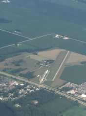
By: anonymous


