Login
Register


SCB
Scribner State Airport
Official FAA Data Effective 2026-02-19 0901Z
Chart Supplement

VFR Chart of KSCB
Sectional Charts at SkyVector.com
IFR Chart of KSCB
Enroute Charts at SkyVector.com
Location Information for KSCB
Coordinates: N41°36.64' / W96°37.79'Located 03 miles SE of Scribner, Nebraska on 789 acres of land. View all Airports in Nebraska.
Surveyed Elevation is 1324 feet MSL.
Operations Data
|
|
Airport Communications
| OMAHA APPROACH: | 135.875 354.05 |
|---|---|
| OMAHA DEPARTURE: | 135.875 354.05 |
| CTAF: | 122.900 |
| AWOS-3 at FET (10.8 SE): | 121.275 402-727-9135 |
| ASOS at TQE (22.2 NE): | 127.275 402-374-2853 |
| AWOS-3P at AHQ (22.3 S): | 125.975 402-443-4030 |
Nearby Navigation Aids
|
| ||||||||||||||||||||||||||||||||||||||||||||||||||||||||||||


Runway 17/35
| Dimensions: | 4200 x 75 feet / 1280 x 23 meters | |
|---|---|---|
| Surface: | Concrete in Excellent Condition | |
| Weight Limits: | S-25 | |
| Edge Lighting: | Medium Intensity | |
| Runway 17 | Runway 35 | |
| Coordinates: | N41°37.16' / W96°37.56' | N41°36.47' / W96°37.55' |
| Elevation: | 1318.2 | 1319.9 |
| Traffic Pattern: | Left | Left |
| Runway Heading: | 179° True | 359° True |
| Markings: | Non-Precision Instrument in good condition. | Non-Precision Instrument in good condition. |
Runway 12/30
| Dimensions: | 2820 x 60 feet / 860 x 18 meters | |
|---|---|---|
| Surface: | Concrete in Poor Condition 12/30 2019 PCI SCORE RATED AS POOR; RWY HAS HIGH SEVERITY LINEAR CRACKS THROUGHOUT RWY, FOD PRESENT. | |
| Runway 12 | Runway 30 | |
| Coordinates: | N41°36.55' / W96°38.36' | N41°36.23' / W96°37.92' |
| Elevation: | 1322.5 | 1318.8 |
| Runway Heading: | 134° True | 314° True |
| Markings: | Basic in good condition. | Basic in good condition. |
Services Available
| Fuel: | 100LL (blue) |
|---|---|
| Transient Storage: | Tiedowns |
| Airframe Repair: | NONE |
| Engine Repair: | NONE |
| Bottled Oxygen: | NONE |
| Bulk Oxygen: | NONE |
| Other Services: | CROP DUSTING SERVICES |
Ownership Information
| Ownership: | Publicly owned | |
|---|---|---|
| Owner: | NEBR. DOT, DIVISION OF AERONAUTICS | |
| 1600 NEBRASKA PARKWAY | ||
| LINCOLN, NE 68502-4101 | ||
| 402-471-2371 | ||
| Manager: | CHRIS HOWARD | |
| 3227 NEBRASKA AVE, SCRIBNER STATE AIRFIELD | ||
| FREMONT, NE 68025-2205 | ||
| 402-480-2434 | SHOP FONE 402-654-2200. | |
Other Remarks
- FOR CD CTC OMAHA APCH AT 402-682-4395.
- 0LL CTC AMGR FOR FUEL. CASH OR CHECK ONLY.
- ACTVT MIRL RWY 17/35 - CTAF.
- ROTG BCN OTS INDEF.
Weather Minimums

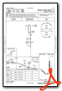
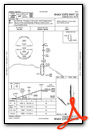
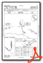
Instrument Approach Procedure (IAP) Charts
Nearby Airports with Instrument Procedures
| ID | Name | Heading / Distance | ||
|---|---|---|---|---|
 |
KFET | Fremont Municipal Airport | 153° | 10.8 |
|
KTQE | Tekamah Municipal Airport | 065° | 22.3 |
|
KAHQ | Wahoo Municipal Airport | 175° | 22.3 |
|
KBTA | Blair Exec Airport | 116° | 26.3 |
|
0C4 | Pender Municipal Airport | 351° | 30.5 |
|
93Y | David City Municipal Airport | 224° | 31.9 |
|
KOLU | Columbus Municipal Airport | 253° | 33.5 |
|
KMLE | Millard Airport | 136° | 34.1 |
|
KOMA | Eppley Airfield Airport | 118° | 38.0 |
|
KLCG | Wayne Municipal/Stan Morris Field Airport | 337° | 41.0 |
|
KOFK | Norfolk Regional/Karl Stefan Memorial Field Airport | 302° | 42.6 |
|
KOFF | Offutt AFB Airport | 131° | 43.9 |
Airport Images
Do you have a recent image of this airport? Upload it here!


