Login
Register
7M6
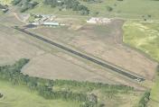
Paris Municipal Airport
Official FAA Data Effective 2026-01-22 0901Z
VFR Chart of 7M6
Sectional Charts at SkyVector.com
IFR Chart of 7M6
Enroute Charts at SkyVector.com
Location Information for 7M6
Coordinates: N35°17.95' / W93°40.90'Located 02 miles E of Paris /Subiaco/, Arkansas on 70 acres of land. View all Airports in Arkansas.
Estimated Elevation is 430 feet MSL.
Operations Data
|
|
Airport Communications
| CTAF: | 122.900 |
|---|---|
| ASOS at RUE (28.9 E): | 132.475 479-968-2267 |
| ASOS at FSM (33.6 W): | 479-649-2425 |
| ATIS at FSM (33.6 W): | 124.775 |
Nearby Navigation Aids
|
| ||||||||||||||||||||||||||||||||||||||||||||||||||||||
Runway 03/21
| Dimensions: | 2710 x 60 feet / 826 x 18 meters | |
|---|---|---|
| Surface: | Asphalt in Good Condition | |
| Weight Limits: | S-10 | |
| Edge Lighting: | Medium Intensity MIRL OTS INDEFLY. | |
| Runway 03 | Runway 21 | |
| Coordinates: | N35°17.77' / W93°41.07' | N35°18.12' / W93°40.73' |
| Elevation: | 422.0 | 403.0 |
| Traffic Pattern: | Left | Left |
| Runway Heading: | 39° True | 219° True |
| Markings: | Non-Standard in good condition. | Non-Standard in good condition. |
| Glide Slope Indicator | P2L (3.00° Glide Path Angle) PAPI OTS INDEFLY. | |
| Obstacles: | 15 ft Road 450 ft from runway | 30 ft Tree 350 ft from runway, 270 ft left of center |
Services Available
| Fuel: | NONE |
|---|---|
| Transient Storage: | Hangars,Tiedowns |
| Airframe Repair: | NOT AVAILABLE |
| Engine Repair: | NOT AVAILABLE |
| Bottled Oxygen: | NOT AVAILABLE |
| Bulk Oxygen: | NOT AVAILABLE |
| Other Services: | CROP DUSTING SERVICES,AIR AMBULANCE SERVICES |
Ownership Information
| Ownership: | Publicly owned | |
|---|---|---|
| Owner: | CITY OF PARIS | |
| PO BOX 271 | ||
| PARIS, AR 72855 | ||
| 479-963-2450 | ||
| Manager: | KEN TURNER | |
| P.O. BOX 271 | ||
| PARIS, AR 72855 | ||
| 479-629-0734 | ||
Other Remarks
- AGRICULTURE OPS FEB-OCT BLO 500 FT AGL.
- FOR CD CTC MEMPHIS ARTCC AT 901-368-8453/8449.
- ACTVT MIRL RWY 03/21 - CTAF
Nearby Airports with Instrument Procedures
| ID | Name | Heading / Distance | ||
|---|---|---|---|---|
 |
7M5 | Ozark/Franklin County Airport | 328° | 14.8 |
 |
H35 | Clarksville Municipal Airport | 050° | 16.2 |
 |
32A | Danville Municipal Airport | 135° | 17.8 |
 |
KRUE | Russellville Regional Airport | 094° | 29.0 |
 |
KFSM | Fort Smith Regional Airport | 274° | 33.7 |
 |
KMPJ | Petit Jean Park Airport | 103° | 39.2 |
 |
H34 | Huntsville Municipal Airport | 355° | 46.8 |
 |
KBDQ | Morrilton Municipal Airport | 101° | 48.6 |
 |
KFYV | Drake Field Airport | 330° | 48.6 |
 |
KRKR | Robert S Kerr Airport | 250° | 49.1 |
 |
KMEZ | Mena Intermountain Municipal Airport | 209° | 51.9 |
 |
KJSV | Sallisaw Municipal Airport | 278° | 55.6 |


