Login
Register


7S7
Valier Airport
Official FAA Data Effective 2026-01-22 0901Z
Chart Supplement

VFR Chart of 7S7
Sectional Charts at SkyVector.com
IFR Chart of 7S7
Enroute Charts at SkyVector.com
Location Information for 7S7
Coordinates: N48°18.01' / W112°15.07'Located 01 miles S of Valier, Montana on 62 acres of land. View all Airports in Montana.
Estimated Elevation is 3826 feet MSL.
Operations Data
|
|
Airport Communications
| CTAF: | 122.900 |
|---|---|
| ASOS at CTB (18.9 N): | 119.025 406-873-2939 |
| AWOS-3PT at SBX (20.8 NE): | 128.325 406-434-2542 |
| AWOS-2 at CII (28.6 S): | 119.275 406-466-2259 |
Nearby Navigation Aids
|
| ||||||||||||||||||||||||||||||


Runway 07/25
| Dimensions: | 3075 x 150 feet / 937 x 46 meters | |
|---|---|---|
| Surface: | Turf in Fair Condition | |
| Runway 07 | Runway 25 | |
| Coordinates: | N48°18.01' / W112°15.39' | N48°18.00' / W112°14.63' |
| Traffic Pattern: | Left | Right |
| Obstacles: | +24 FT TREES ON RWY CNTRLN EXTNDD. |
15 ft Road 40 ft from runway |
Runway 04/22
| Dimensions: | 2280 x 300 feet / 695 x 91 meters | |
|---|---|---|
| Surface: | Turf in Fair Condition | |
| Runway 04 | Runway 22 | |
| Traffic Pattern: | Left | Right |
| Obstacles: | 4 ft Fence 10 ft from runway, 50 ft right of center +10 FT TREES ON RWY CNTRLN EXTNDD. |
|
Runway 10/28
| Dimensions: | 2140 x 130 feet / 652 x 40 meters | |
|---|---|---|
| Surface: | Turf in Fair Condition | |
| Runway 10 | Runway 28 | |
| Coordinates: | N48°18.12' / W112°15.37' | N48°17.91' / W112°14.94' |
| Elevation: | 3826.0 | 3826.0 |
| Traffic Pattern: | Left | Right |
| Runway Heading: | 126° True | 306° True |
| Obstacles: | 24 ft Building 550 ft from runway, 125 ft left of center +375 FT WTR TWR 218 FT LEFT OF RWY CNTRLN 110 FT TALL RWY 10 END. |
36 ft Trees 300 ft from runway +15 FT' TREES ON RWY CNTRLN EXTNDD. |
Services Available
| Fuel: | NONE |
|---|---|
| Transient Storage: | Tiedowns |
| Airframe Repair: | NONE |
| Engine Repair: | NONE |
| Bottled Oxygen: | NONE |
| Bulk Oxygen: | NONE |
| Other Services: | CROP DUSTING SERVICES |
Ownership Information
| Ownership: | Publicly owned | |
|---|---|---|
| Owner: | PONDERA COUNTY | |
| PONDERA CTY COURTHOUSE | ||
| CONRAD, MT 59425 | ||
| 406-278-7681 | ||
| Manager: | HEATH ELINGS | |
| 24TH AVE | ||
| CONRAD, MT 59425 | ||
| (406) 450-1620 | ||
Other Remarks
- WATERFOWL ON & INVOF ARPT.
- FOR CD CTC SALT LAKE ARTCC AT 801-320-2568.
- 07/25 RWY 10/28 & RWY 04/22 MKD WITH W CONES FULL LEN.
Nearby Airports with Instrument Procedures
| ID | Name | Heading / Distance | ||
|---|---|---|---|---|
 |
S01 | Conrad Airport | 125° | 13.6 |
|
KCTB | Cut Bank International Airport | 344° | 19.2 |
|
KSBX | Shelby Airport | 046° | 21.0 |
|
KCII | Choteau Airport | 173° | 28.5 |
|
KGTF | Great Falls International Airport | 143° | 60.6 |
|
79S | Fort Benton Airport | 112° | 70.5 |
|
KGPI | Glacier Park International Airport | 271° | 80.3 |
|
8S1 | Polson Airport | 245° | 86.0 |
|
7S0 | Ronan Airport | 240° | 86.6 |
|
KHVR | Havre City-County Airport | 080° | 100.5 |
|
CZPC | Pincher Creek Airport | 317° | 100.7 |
|
KHLN | Helena Regional Airport | 173° | 102.2 |
Airport Images
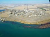
By: tphilips


