Login
Register
7VG0
Lost Griz Aerodrome Airport
Official FAA Data Effective 2024-12-26 0901Z
VFR Chart of 7VG0
Sectional Charts at SkyVector.com
IFR Chart of 7VG0
Enroute Charts at SkyVector.com
Location Information for 7VG0
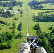
Coordinates: N38°39.34' / W77°47.23'Located 04 miles S of Warrenton, Virginia on 60 acres of land. View all Airports in Virginia.
Surveyed Elevation is 442 feet MSL.
Operations Data
|
|
Airport Communications
| AWOS-3 at HWY (5.3 SE): | 120.350 540-788-4078 |
|---|---|
| AWOS-3 at CJR (8.4 SW): | 119.325 540-727-0523 |
| AWOS-3PT at HEF (13.3 E): | 703-361-6160 |
Nearby Navigation Aids
|
| ||||||||||||||||||||||||||||||||||||||||||||||||||||||||||||
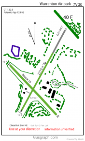
Runway 04/22
| Dimensions: | 2215 x 70 feet / 675 x 21 meters NARROWS TO 70 FT USBL AT BRIDGE OVER STREAM MOWED TO 240 FT WIDE. | |
|---|---|---|
| Surface: | Turf in Good Condition | |
| Runway 04 | Runway 22 | |
| Displaced Threshold: | 1000 Feet | |
| Obstacles: | 4 ft Fence 6 ft from runway | 10 ft Trees 100 ft from runway |
Runway 15/33
LANDING ONLY RWY 33; NO TAKEOFFS RWY 33; NO TAKEOFFS/LANDINGS RWY 15. | ||
| Dimensions: | 2000 x 70 feet / 610 x 21 meters UPSLOPE LAST 800 FT OF RWY 33. WIDTH MOWED & MKD BY ORANGE CONES; TURF AREA APRXLY 250 FT WIDE. | |
|---|---|---|
| Surface: | Turf in Good Condition | |
| Runway 15 | Runway 33 | |
| Traffic Pattern: | Left | Left |
| Obstacles: | 40 ft Trees 25 ft from runway, 80 ft right of center | 40 ft Trees 40 ft from runway, 95 ft right of center |
Services Available
| Fuel: | NONE |
|---|---|
| Transient Storage: | Tiedowns |
| Airframe Repair: | NONE |
| Engine Repair: | NONE |
| Bottled Oxygen: | NONE |
| Bulk Oxygen: | NONE |
| Other Services: | GLIDER SERVICE,PILOT INSTRUCTION,AIRCRAFT SALES,GLIDER TOWING SERVICES |
Ownership Information
| Ownership: | Privately Owned | |
|---|---|---|
| Owner: | MATT AND ERICA CHRISTENSEN | |
| 9270 GREEN MEADOWS RD | ||
| WARRENTON, VA 20187 | ||
| 703-483-0776 | ||
| Manager: | MATT CHRISTENSEN | |
| 9270 GREEN MEADOWS RD | ||
| WARRENTON, VA 20187 | ||
| 703-483-0776 | ||
Other Remarks
- 880 FT X 18 FT PAVED TKOFF PATCH RWY 04/22.
- SKYDIVING ACTV WEDNESDAY THRU MONDAY FLYING 750 HP TURBOPROP ACFT.
- FRQ OPS APR - NOV, SPCLY ON WKENDS.
- POWER PARAGLIDER OPS INVOF ARPT.
- FOR CD CTC POTOMAC APCH AT 866-709-4993.
- 04/22 ENDS MARKED WITH CONES.
Nearby Airports with Instrument Procedures
| ID | Name | Heading / Distance | ||
|---|---|---|---|---|
 |
KHWY | Warrenton/Fauquier Airport | 139° | 5.5 |
 |
KCJR | Culpeper Regional Airport | 203° | 8.5 |
 |
KHEF | Manassas Regional/Harry P Davis Field Airport | 072° | 13.4 |
 |
KRMN | Stafford Regional Airport | 134° | 21.9 |
 |
KIAD | Washington Dulles International Airport | 041° | 23.3 |
 |
KNYG | Quantico Mcaf (Turner Field) Airport | 111° | 24.4 |
 |
KFRR | Front Royal-Warren County Airport | 305° | 26.9 |
 |
KOMH | Orange County Airport | 206° | 27.3 |
 |
KJYO | Leesburg Exec Airport | 022° | 27.5 |
 |
KEZF | Shannon Airport | 145° | 28.2 |
 |
KDAA | Davison AAF Airport | 082° | 28.7 |
 |
KLUA | Luray Caverns Airport | 271° | 33.5 |


