Login
Register


LUA
Luray Caverns Airport
Official FAA Data Effective 2026-02-19 0901Z
Chart Supplement

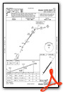
VFR Chart of KLUA
Sectional Charts at SkyVector.com
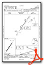
IFR Chart of KLUA
Enroute Charts at SkyVector.com
Location Information for KLUA
Coordinates: N38°40.00' / W78°30.05'Located 02 miles W of Luray, Virginia on 108 acres of land. View all Airports in Virginia.
Surveyed Elevation is 902 feet MSL.
Operations Data
|
|
Airport Communications
| AWOS-3: | 118.275 Tel. 540-743-1148 |
|---|---|
| CTAF: | 122.800 |
| UNICOM: | 122.800 |
| AWOS-3 at 8W2 (9.8 W): | 118.175 540-740-3801 |
| AWOS-3 at FRR (19.1 NE): | 121.85 540-635-5377 |
| AWOS-3 at VBW (28.1 SW): | 119.55 540-828-2076 |
- APCH/DEP SVC PRVDD BY WASHINGTON ARTCC ON FREQS 133.2/282.2 (BUCKS ELBOW RCAG).
Nearby Navigation Aids
|
| ||||||||||||||||||||||||||||||||||||||||||||||||||||||||||||


Runway 04/22
| Dimensions: | 3126 x 75 feet / 953 x 23 meters | |
|---|---|---|
| Surface: | Asphalt in Good Condition | |
| Weight Limits: | S-12 | |
| Edge Lighting: | Medium Intensity | |
| Runway 04 | Runway 22 | |
| Coordinates: | N38°39.79' / W78°30.24' | N38°40.21' / W78°29.86' |
| Elevation: | 902.4 | 901.9 |
| Traffic Pattern: | Left | Right |
| Runway Heading: | 35° True | 215° True |
| Markings: | Non-Precision Instrument in poor condition. | Non-Precision Instrument in poor condition. |
| Glide Slope Indicator | P2L (3.00° Glide Path Angle) | P2L (3.00° Glide Path Angle) |
| REIL: | Yes | Yes |
| Obstacles: | 28 ft Tree 940 ft from runway, 290 ft right of center | 9 ft Road 200 ft from runway, 185 ft left of center 10 FT ROAD LCTD 80 FT FM END OF RWY, 230 FT LEFT ON APCH. |
Services Available
| Fuel: | 100LL (blue), Jet A+ |
|---|---|
| Transient Storage: | Hangars,Tiedowns |
| Airframe Repair: | MAJOR |
| Engine Repair: | MAJOR |
| Bottled Oxygen: | NOT AVAILABLE |
| Bulk Oxygen: | NOT AVAILABLE |
Ownership Information
| Ownership: | Publicly owned | |
|---|---|---|
| Owner: | LURAY & PAGE CO. AIRPORT AUTHORITY | |
| 1086 AIRPORT ROAD | ||
| LURAY, VA 22835 | ||
| (540) 743-6070 | ||
| Manager: | JAMES CULPEPPER | |
| 1086 AIRPORT ROAD | ||
| LURAY, VA 22835 | ||
| 540-743-6070 | ||
Other Remarks
- DEER AND BIRDS ON AND INVOF ARPT.
- FOR CD CTC WASHINGTON ARTCC AT 703-771-3587.
- RWY 4 MRKGS CVRD WITH ALGAE.
- RWY 22 MRKGS CVRD WITH ALGAE.
- ACTVT REIL RWY 04/22; MIRL RWY 04/22 - CTAF.
Weather Minimums

Instrument Approach Procedure (IAP) Charts


Nearby Airports with Instrument Procedures
| ID | Name | Heading / Distance | ||
|---|---|---|---|---|
 |
8W2 | New Market Airport | 266° | 9.8 |
|
KFRR | Front Royal-Warren County Airport | 037° | 19.0 |
|
KVBW | Bridgewater Air Park Airport | 230° | 28.1 |
|
KSHD | Shenandoah Valley Regional Airport | 217° | 30.5 |
|
KCJR | Culpeper Regional Airport | 105° | 31.3 |
|
KCHO | Charlottesville-Albemarle Airport | 175° | 31.7 |
|
KOMH | Orange County Airport | 139° | 33.1 |
|
KOKV | Winchester Regional Airport | 030° | 33.1 |
|
KGVE | Gordonsville Municipal Airport | 152° | 34.4 |
|
W99 | Grant County Airport | 303° | 36.1 |
|
KHWY | Warrenton/Fauquier Airport | 097° | 37.5 |
|
W13 | Eagle's Nest Airport | 210° | 41.1 |


Comments
Great place to visit
What a great place. I flew into Luray today with a friend and kids, and was greeted over unicom by Kenny who gave us tie-down instructions and offered to give us a ride to wherever we were going. We were headed to Luray Caverns and welcomed the ride. Not only did he drop us off, but said to give him a call when we were ready to head back and we did. He picked us up and dropped us plane side! What great service from such a friendly group there. It's a great place to fly into and do a quick run to Luray. They even have LED runway lights! Thanks Kenny!
Friendly with fantastic views
Wow what a great fuel stop on my cross-country trip. They have crew cars and the caverns are just a mile away. I will be back.
Pages