Login
Register


7W4
Lake Anna Airport
Official FAA Data Effective 2026-02-19 0901Z
Chart Supplement

VFR Chart of 7W4
Sectional Charts at SkyVector.com
IFR Chart of 7W4
Enroute Charts at SkyVector.com
Location Information for 7W4
Coordinates: N37°57.95' / W77°44.75'Located 00 miles NW of Bumpass, Virginia on 134 acres of land. View all Airports in Virginia.
Estimated Elevation is 351 feet MSL.
Operations Data
|
|
Airport Communications
| AWOS-3: | 120.775 Tel. 540-872-0303 |
|---|---|
| POTOMAC APPROACH: | 126.75 307.2 |
| POTOMAC DEPARTURE: | 126.75 307.2 |
| CTAF: | 122.900 |
| AWOS-3 at LKU (10.8 W): | 119.475 540-967-1983 |
| ASOS at OFP (21.3 SE): | 119.025 804-752-2902 |
| AWOS-3 at OMH (22.1 NW): | 118.075 540-672-0505 |
- APCH/DEP SVC PRVDD BY POTOMAC TRACON 126.75/307.2 .
Nearby Navigation Aids
|
| ||||||||||||||||||||||||||||||||||||||||||||||||||||||||||||


Runway 08/26
| Dimensions: | 2558 x 50 feet / 780 x 15 meters | |
|---|---|---|
| Surface: | Asphalt in Good Condition | |
| Weight Limits: | S-6 | |
| Edge Lighting: | Medium Intensity | |
| Runway 08 | Runway 26 | |
| Coordinates: | N37°57.89' / W77°45.01' | N37°58.01' / W77°44.50' |
| Elevation: | 349.5 | 351.2 |
| Traffic Pattern: | Left | Left |
| Runway Heading: | 75° True | 255° True |
| Markings: | Non-Precision Instrument in good condition. | Non-Precision Instrument in good condition. |
| Obstacles: | 63 ft Trees 1011 ft from runway, 13 ft left of center | 59 ft Tree 1022 ft from runway, 116 ft left of center |
Services Available
| Fuel: | NONE |
|---|---|
| Transient Storage: | Tiedowns |
| Airframe Repair: | NONE |
| Engine Repair: | NONE |
| Bottled Oxygen: | NONE |
| Bulk Oxygen: | NONE |
Ownership Information
| Ownership: | Privately Owned | |
|---|---|---|
| Owner: | MILE HIGH CHARTERS, LLC | |
| 10267 MATTHEWS GROVE LN. | ||
| MECHANICSVILLE, VA 23116 | ||
| 804-550-5794 | ||
| Manager: | RICHARD HENRY REMPE | |
| 10267 MATTHEWS GROVE LN. | ||
| MECHANICSVILLE, VA 23116 | ||
| 804-550-5794 | EMERGENCY PHONE NUMBER IS: (804) 514-6642 | |
Other Remarks
- DEER ON & INVOF ARPT.
- FOR CD CTC POTOMAC APCH AT 866-640-4124.
- ACTVT MIRL RY 08/26 - CTAF
- CTAF 122.90
Weather Minimums

Instrument Approach Procedure (IAP) Charts
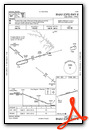

Nearby Airports with Instrument Procedures
| ID | Name | Heading / Distance | ||
|---|---|---|---|---|
 |
KLKU | Louisa County/Freeman Field Airport | 283° | 11.0 |
|
KOFP | Hanover County Municipal Airport | 136° | 21.3 |
|
KOMH | Orange County Airport | 320° | 22.0 |
|
KEZF | Shannon Airport | 037° | 22.9 |
|
KGVE | Gordonsville Municipal Airport | 299° | 22.9 |
|
KRMN | Stafford Regional Airport | 027° | 29.4 |
|
KCJR | Culpeper Regional Airport | 350° | 34.0 |
|
KRIC | Richmond International Airport | 143° | 34.3 |
|
KCHO | Charlottesville-Albemarle Airport | 287° | 35.1 |
|
KFCI | Richmond Exec/Chesterfield County Airport | 162° | 35.1 |
|
KHWY | Warrenton/Fauquier Airport | 002° | 37.2 |
|
KNYG | Quantico Mcaf (Turner Field) Airport | 032° | 38.4 |
Airport Images

By: Big Orange Bird


