Login
Register


8A3
Livingston Municipal Airport
Official FAA Data Effective 2026-02-19 0901Z
Chart Supplement

VFR Chart of 8A3
Sectional Charts at SkyVector.com
IFR Chart of 8A3
Enroute Charts at SkyVector.com
Location Information for 8A3
Coordinates: N36°24.81' / W85°18.63'Located 02 miles NE of Livingston, Tennessee on 183 acres of land. View all Airports in Tennessee.
Surveyed Elevation is 1372 feet MSL.
Operations Data
|
|
Airport Communications
| AWOS-3: | 126.175 Tel. 931-823-3329 |
|---|---|
| CTAF: | 122.800 |
| UNICOM: | 122.800 |
| AWOS-3P at SRB (24.3 SW): | 128.25 931-738-3111 |
| AWOS-AV at TZV (25.2 NW): | 124.175 |
| ASOS at CSV (29.9 S): | 120.625 931-456-4406 |
- APCH/DEP SVC PRVDD BY INDIANAPOLIS ARTCC ON FREQS 124.625/371.925 (LONDON 2 RCAG).
Nearby Navigation Aids
|
| ||||||||||||||||||||||||||||||||||||||||||||||||||||||||||||


Runway 03/21
| Dimensions: | 5153 x 75 feet / 1571 x 23 meters | |
|---|---|---|
| Surface: | Asphalt in Good Condition | |
| Weight Limits: | 11 /F/C/X/T, S-31, D-47 | |
| Edge Lighting: | Medium Intensity | |
| Runway 03 | Runway 21 | |
| Coordinates: | N36°24.46' / W85°18.92' | N36°25.16' / W85°18.34' |
| Elevation: | 1365.7 | 1370.3 |
| Traffic Pattern: | Left | Left |
| Runway Heading: | 33° True | 213° True |
| Displaced Threshold: | 145 Feet | |
| Declared Distances: | TORA:5125 TODA:5152 ASDA:5152 LDA:5007 | TORA:5007 TODA:5007 ASDA:5007 LDA:5007 |
| Markings: | Non-Precision Instrument in good condition. | Non-Precision Instrument in good condition. |
| Glide Slope Indicator | P2L (4.00° Glide Path Angle) | |
| REIL: | Yes | Yes |
| Obstacles: | SLOPE 55:1 TO DTHR. |
29 ft Trees 833 ft from runway, 136 ft right of center |
Services Available
| Fuel: | 100LL (blue), Jet A+ |
|---|---|
| Transient Storage: | Hangars,Tiedowns |
| Airframe Repair: | NOT AVAILABLE |
| Engine Repair: | NOT AVAILABLE |
| Bottled Oxygen: | NOT AVAILABLE |
| Bulk Oxygen: | NOT AVAILABLE |
| Other Services: | PILOT INSTRUCTION |
Ownership Information
| Ownership: | Publicly owned | |
|---|---|---|
| Owner: | CITY OF LIVINGSTON | |
| CITY HALL, 310 MCHENRY CIRCLE | ||
| LIVINGSTON, TN 38570 | ||
| 931-823-1269 | ||
| Manager: | EDNA WINNINGHAM | |
| 632 AIRPORT RD | ||
| LIVINGSTON, TN 38570 | ||
| 931-823-3671 | ||
Other Remarks
- SELF SVC FUEL H24 WITH CREDIT CARD.
- FOR CD CTC INDIANAPOLIS ARTCC AT 317-247-2411.
- ACTV REIL RWY 03 & 21; PAPI RWY 21; MIRL RWY 03/21 - CTAF.
Weather Minimums

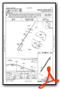
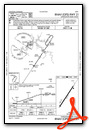
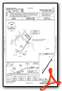
Instrument Approach Procedure (IAP) Charts
Nearby Airports with Instrument Procedures
| ID | Name | Heading / Distance | ||
|---|---|---|---|---|
 |
2A1 | Jamestown Municipal Airport | 102° | 18.0 |
|
KSRB | Upper Cumberland Regional Airport | 206° | 23.9 |
|
KTZV | Tompkinsville/Monroe County Airport | 318° | 25.1 |
|
KCSV | Crossville Memorial-Whitson Field Airport | 158° | 29.8 |
|
KEKQ | Wayne County Airport | 039° | 34.4 |
|
KSCX | Scott Municipal Airport | 085° | 35.2 |
|
0A3 | Smithville Municipal Airport | 223° | 35.3 |
|
3M7 | Lafayette Municipal Airport | 280° | 36.7 |
|
K24 | Russell County Airport | 015° | 37.1 |
|
KRKW | Rockwood Municipal Airport | 134° | 42.1 |
|
18I | Mc Creary County Airport | 068° | 47.5 |
|
KGLW | Glasgow Municipal Airport | 320° | 48.3 |
Airport Images

By: Big Orange Bird

By: Big Orange Bird


