Login
Register


CSV
Crossville Memorial-Whitson Field Airport
Official FAA Data Effective 2026-01-22 0901Z
Chart Supplement

VFR Chart of KCSV
Sectional Charts at SkyVector.com
IFR Chart of KCSV
Enroute Charts at SkyVector.com
Location Information for KCSV
Coordinates: N35°57.08' / W85°5.10'Located 03 miles W of Crossville, Tennessee on 418 acres of land. View all Airports in Tennessee.
Surveyed Elevation is 1881 feet MSL.
Operations Data
|
|
Airport Communications
| ASOS: | 120.625 Tel. 931-456-4406 |
|---|---|
| CTAF: | 122.700 |
| UNICOM: | 122.700 |
| AWOS-3 at RKW (19.3 E): | 118.775 865-354-9262 |
| AWOS-3P at SRB (22.7 W): | 128.25 931-738-3111 |
| AWOS-3 at 2A0 (29.2 S): | 135.075 423-775-4695 |
- APCH/DEP SVC PRVDD BY ATLANTA ARTCC ON FREQS 133.6/254.3 (HINCH MOUNTAIN RCAG).
Nearby Navigation Aids
|
| ||||||||||||||||||||||||||||||||||||||||||||||||||||||


Runway 08/26
| Dimensions: | 5423 x 100 feet / 1653 x 30 meters | |
|---|---|---|
| Surface: | Asphalt in Good Condition | |
| Weight Limits: | 22 /F/D/X/T, S-56, D-73 | |
| Edge Lighting: | High Intensity | |
| Runway 08 | Runway 26 | |
| Coordinates: | N35°56.95' / W85°5.63' | N35°57.20' / W85°4.57' |
| Elevation: | 1880.9 | 1866.9 |
| Traffic Pattern: | Left | Left |
| Runway Heading: | 73° True | 253° True |
| Markings: | Precision Instrument in good condition. | Precision Instrument in good condition. |
| Glide Slope Indicator | V4R (3.00° Glide Path Angle) | P4L (3.00° Glide Path Angle) PAPI UNUSBL BYD 8 DEGS RIGHT OF CNTRLN. |
| REIL: | Yes | |
Services Available
| Fuel: | 100LL (blue), Jet A+ |
|---|---|
| Transient Storage: | Tiedowns |
| Airframe Repair: | MAJOR |
| Engine Repair: | MAJOR |
| Bottled Oxygen: | NOT AVAILABLE |
| Bulk Oxygen: | NOT AVAILABLE |
| Other Services: | PILOT INSTRUCTION,AIRCRAFT RENTAL,AIRCRAFT SALES |
Ownership Information
| Ownership: | Publicly owned | |
|---|---|---|
| Owner: | CITY OF CROSSVILLE | |
| 392 NORTH MAIN | ||
| CROSSVILLE, TN 38555 | ||
| 931-484-5278 | ||
| Manager: | JOHNNA MCCOY | JOHNNA MCCOY |
| 2409 SPARTA HIGHWAY | ||
| CROSSVILLE, TN 38555 | ||
| 931-979-0731 | ||
Other Remarks
- FOR CD IF UNA TO CTC ON FSS FREQ, CTC ATLANTA ARTCC AT 770-210-7692.
- AFT HR - 931-267-5214.
- HIRL RWY 08/26 PRESET LOW INTST; INCR INTST - CTAF.
Weather Minimums


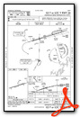
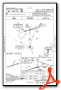
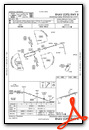
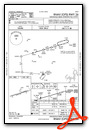
Instrument Approach Procedure (IAP) Charts
Nearby Airports with Instrument Procedures
| ID | Name | Heading / Distance | ||
|---|---|---|---|---|
 |
KRKW | Rockwood Municipal Airport | 095° | 19.3 |
|
KSRB | Upper Cumberland Regional Airport | 286° | 22.6 |
|
2A1 | Jamestown Municipal Airport | 015° | 24.8 |
|
2A0 | Mark Anton Airport | 164° | 28.9 |
|
8A3 | Livingston Municipal Airport | 338° | 29.8 |
|
0A3 | Smithville Municipal Airport | 273° | 35.3 |
|
KSCX | Scott Municipal Airport | 038° | 38.7 |
|
KRNC | Warren County Memorial Airport | 247° | 40.0 |
|
KMMI | Mcminn County Airport | 142° | 41.8 |
|
KMNV | Monroe County Airport | 125° | 42.1 |
|
KRZR | Cleveland Regional Jetport Airport | 162° | 46.4 |
|
KJAU | Colonel Tommy C Stiner Airfield Airport | 062° | 50.3 |
Fuel Providers

Airport Images

By: 2flaps

By: Big Orange Bird


