Login
Register
99V
Crawford Airport
Official FAA Data Effective 2026-01-22 0901Z
VFR Chart of 99V
Sectional Charts at SkyVector.com
IFR Chart of 99V
Enroute Charts at SkyVector.com
Location Information for 99V
Coordinates: N38°42.25' / W107°38.62'Located 02 miles W of Crawford, Colorado on 40 acres of land. View all Airports in Colorado.
Surveyed Elevation is 6470 feet MSL.
Operations Data
|
|
Airport Communications
| UNICOM: | 122.800 |
|---|---|
| CTAF: | 122.800 |
| ASOS at MTJ (16.6 SW): | 135.225 970-249-1534 |
| AWOS-3 at AJZ (20.4 W): | 134.0 970-874-3251 |
| AWOS-3PT at GUC (34.9 E): | 135.075 970-641-3240 |
Nearby Navigation Aids
|
| ||||||||||||||||||||||||||||||||||||
Runway 07/25
LND TO THE EAST; TKOF TO THE WEST WINDS PERMITTING. | ||
| Dimensions: | 4900 x 20 feet / 1494 x 6 meters WEST 1300 FT ONLY 25 FT WIDE. | |
|---|---|---|
| Surface: | Asphalt in Fair Condition | |
| Edge Lighting: | Low Intensity NSTD LIRL; RY 07/25 HAS LIRL ONLY ON NORTH SIDE ON RY FOR CENTER 1600 FT BEGINNING 1200 EAST OF RY 7 THLD. NO THLD LIGHTS. RY 07/25 3800 FT USBL FOR NIGHT OPNS. | |
| Runway 07 | Runway 25 | |
| Coordinates: | N38°42.16' / W107°39.35' | N38°42.27' / W107°38.33' |
| Traffic Pattern: | Right | |
| Glide Slope Indicator | NSTD NSTD VASI, HAS 1 VASI BOX ON LEFT AND RIGHT SIDE OF RY. FOR LOCAL OPERATORS ONLY OR PPR CALL 970-921-7700. | |
| Obstacles: | 27 ft Trees 340 ft from runway, 90 ft left of center HAS 10 FT ROAD EXTENDING WEST FROM RY THRESHOLD. |
19 ft Hangar 205 ft from runway, 65 ft left of center HAS 20 FT TREES 50 FT FROM THLD 50 FT L & R OF CNTRLN; +25 FT BUILDING 150 FT FM THLD 30 FT L OF CNTRLN. |
Runway E/W
| Dimensions: | 2500 x 125 feet / 762 x 38 meters | |
|---|---|---|
| Surface: | Turf in Fair Condition HAS 6 INCH DIAMETER IRRIGATION PIPES CROSSING RUNWAY WIDTH IN VARIOUS PLACES. CONSISTS OF +12 INCH ALFALFA VEGETATION DURING VARIOUS TIMES OF THE YEAR. | |
| Runway E | Runway W | |
| Traffic Pattern: | Right | |
| Obstacles: | 40 ft Trees 210 ft from runway | |
Services Available
| Fuel: | NONE |
|---|---|
| Transient Storage: | Hangars,Tiedowns |
| Airframe Repair: | MINOR |
| Engine Repair: | MINOR |
| Bottled Oxygen: | NOT AVAILABLE |
| Bulk Oxygen: | NOT AVAILABLE |
| Other Services: | GLIDER SERVICE,PILOT INSTRUCTION,GLIDER TOWING SERVICES |
Ownership Information
| Ownership: | Privately Owned | |
|---|---|---|
| Owner: | STEARMAN AVIATION INC | |
| 38500 FRENCH FIELD WAY | ||
| CRAWFORD, CO 81415 | ||
| 970-921-7700 | ||
| Manager: | F LYNN FRENCH | OR CALL ROB DUNCAN 970-921-3400 |
| 38400 FRENCH FIELD WAY | ||
| CRAWFORD, CO 81415 | ||
| 970-921-7700 | ||
Other Remarks
- +45 FT TREE 100 FT L OF RY 07 EXTDD CNTRLN 414 FT FM RY END.
- GLIDER OPERATIONS INVOF ARPT.
- RY 07, HAS 40 FT TREES AND -10 FT TO -20FT TERRAIN 20 FT RIGHT OF RY FIRST 150 FT.
- FOR CD CTC DENVER ARTCC AT 303-651-4257.
- RY 25 HAS +20 FT TREES 300 FT FM THLD 0B.
- RY 25 HAS 50 FT WATER TANKS 900 FT FM THLD ON EXTDD CNTRLN; +2 FT ELECTRIC BOX 150 FT FM THLD 30 FT R; +10 FT RD 100 FT FM THLD 0B.
- PEDESTRIANS, MOTOR VEHICLES, DEER AND WILDLIFE ON & INVOF ARPT.
- RY E HAS +20 FT TREES AT THLD 150 FT R OF CNTRLN; +10 FT TREES 150 FT FM THLD 0B.
- RY W HAS +35 FT BLDG 170 FT WEST OF THLD 30 FT L; +10 RD 100 FT FM THLD CNTRLN; +15 FT TREES 150 FT FM THLD 0B.
- UNLIMITED VEHICLE USE ON ARPT.
- (A70) 100LL FUEL AVBL FOR EMERG USE ONLY.
- -8 FT TO -20 FT TERRAIN OFF BOTH SIDES OF FIRST 674 FT OF RY 25 END.
- DUSK-0000
Nearby Airports with Instrument Procedures
| ID | Name | Heading / Distance | ||
|---|---|---|---|---|
 |
KMTJ | Montrose Regional Airport | 225° | 16.6 |
 |
KAJZ | Blake Field Airport | 284° | 20.2 |
 |
KGUC | Gunnison-Crested Butte Regional Airport | 106° | 35.0 |
 |
KTEX | Telluride Regional Airport | 195° | 46.7 |
 |
KASE | Aspen-Pitkin County/Sardy Field Airport | 049° | 47.7 |
 |
KGJT | Grand Junction Regional Airport | 301° | 48.3 |
 |
KRIL | Rifle Garfield County Airport | 355° | 49.5 |
 |
KAIB | Hopkins Field Airport | 237° | 51.5 |
 |
KEGE | Eagle County Regional Airport | 030° | 65.7 |
 |
KLXV | Lake County Airport | 063° | 69.4 |
 |
KAEJ | Central Colorado Regional Airport | 084° | 71.8 |
 |
KANK | Salida/Harriett Alexander Field Airport | 097° | 75.7 |


Comments
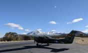
A scenic little private strip
A scenic little private strip where you can practice backcountry technic on pavement or grass. The paved 07/27 is narrow, but in good condition. The runway runs uphill to the east, so land on 07 and depart on 25. Departing 25 is fun, as the runway ends at the edge of the Smith Fork Canyon, which leads into the Black Canyon of the Gunnison. There is an IAP on the field named Mike. There is no public fuel or facilities. Fuel is available close by at Paonia (K7V2) and fuel and full services are available at Montrose (KMJT).