Login
Register


K78
Abilene Municipal Airport
Official FAA Data Effective 2025-11-27 0901Z
Chart Supplement

VFR Chart of K78
Sectional Charts at SkyVector.com
IFR Chart of K78
Enroute Charts at SkyVector.com
Location Information for K78
Coordinates: N38°54.24' / W97°14.15'Located 01 miles SW of Abilene, Kansas on 195 acres of land. View all Airports in Kansas.
Surveyed Elevation is 1152 feet MSL.
Operations Data
|
|
Airport Communications
| AWOS-3P: | 124.125 Tel. 785-802-8625 |
|---|---|
| MARSHALL AAF GCA APPROACH: | 121.25 269.05 |
| MARSHALL AAF GCA DEPARTURE: | 121.25 269.05 |
| CTAF: | 122.800 |
| UNICOM: | 122.800 |
| ATIS at SLN (20.6 W): | 120.15 |
| ASOS at SLN (20.6 W): | 120.15 785-823-3402 |
| ATIS at FRI (23.7 E): | 121.025 |
- APCH/DEP CTL SVC PRVDD BY KANSAS CITY ARTCC (ZKC) ON FREQS 134.9/363.2 (SALINA RCAG) WHEN MASHALL APCH CTL (FRI) CLSD.
Nearby Navigation Aids
|
| ||||||||||||||||||||||||||||||||||||||||||||||||||||||||||||


Runway 18/36
| Dimensions: | 4100 x 75 feet / 1250 x 23 meters | |
|---|---|---|
| Surface: | Concrete in Good Condition | |
| Weight Limits: | 11 /R/C/X/U, S-13, D-16 | |
| Edge Lighting: | Medium Intensity | |
| Runway 18 | Runway 36 | |
| Coordinates: | N38°54.58' / W97°14.15' | N38°53.91' / W97°14.15' |
| Elevation: | 1152.9 | 1150.2 |
| Traffic Pattern: | Left | Left |
| Runway Heading: | 180° True | 0 |
| Displaced Threshold: | 186 Feet | |
| Declared Distances: | TORA:4100 TODA:4100 ASDA:4100 LDA:3914 | TORA:4100 TODA:4100 ASDA:4100 LDA:4100 |
| Markings: | Non-Precision Instrument in good condition. | Non-Precision Instrument in good condition. |
| Glide Slope Indicator | P2L (3.00° Glide Path Angle) | P2L (3.00° Glide Path Angle) |
| REIL: | Yes REIL: LOW/ MEDIUM/ HIGH PILOT CTLD. | Yes REIL: LOW/ MEDIUM/ HIGH PILOT CTLD. |
| Obstacles: | 36 ft Trees 745 ft from runway, 370 ft right of center 23 RR, 630 FT FM THLD. OBSTN CLNC SLOPE 29:1 TO DSPLCD THLD. |
15 ft Road 746 ft from runway, 319 ft left of center |
Services Available
| Fuel: | 100LL (blue) |
|---|---|
| Transient Storage: | Hangars,Tiedowns |
| Airframe Repair: | MAJOR |
| Engine Repair: | MAJOR |
| Bottled Oxygen: | NONE |
| Bulk Oxygen: | NONE |
| Other Services: | CROP DUSTING SERVICES,PILOT INSTRUCTION,PARACHUTE JUMP ACTIVITY,AIRCRAFT RENTAL |
Ownership Information
| Ownership: | Publicly owned | |
|---|---|---|
| Owner: | CITY OF ABILENE KANSAS | |
| CITY BUILDING, 419 N. BROADWAY | ||
| ABILENE, KS 67410 | ||
| 785-263-2550 | ||
| Manager: | JIM CURTIS | |
| 801 S. WASHINGTON | ||
| ABILENE, KS 67410 | ||
| 785-263-3970 | ||
Other Remarks
- COURTESY CAR AVBL.
- FOR CD CTC KANSAS CITY ARTCC AT 913-254-8508.
- 0LL 24 HR SELF SERVE FUEL.
- MIRL RWY 18/36, PAPI RWY 18 & 36, REIL RWY 18 & 36 OPER DUSK-2200; OTHR TIMES ACTVT -- CTAF.
Weather Minimums

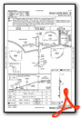
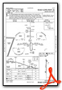
Instrument Approach Procedure (IAP) Charts

Nearby Airports with Instrument Procedures
| ID | Name | Heading / Distance | ||
|---|---|---|---|---|
 |
3JC | Freeman Field Airport | 065° | 20.2 |
|
KSLN | Salina Regional Airport | 250° | 20.7 |
|
KHRU | Herington Regional Airport | 121° | 23.7 |
|
KCYW | Clay Center Municipal Airport | 007° | 29.2 |
|
KMHK | Manhattan Regional Airport | 061° | 30.0 |
|
KMPR | Mc Pherson Airport | 213° | 39.4 |
|
KCNK | Blosser Municipal Airport | 333° | 43.3 |
|
47K | Moundridge Municipal Airport | 196° | 43.5 |
|
9K7 | Ellsworth Municipal Airport | 259° | 47.5 |
|
K38 | Washington County Veteran's Memorial Airport | 009° | 50.6 |
|
KEWK | Newton-City-County Airport | 182° | 50.8 |
|
K61 | Moritz Memorial Airport | 309° | 53.8 |
Airport Images

By: skydvrboy


