Login
Register
A13
Bold Airport
Official FAA Data Effective 2025-12-25 0901Z
VFR Chart of A13
Sectional Charts at SkyVector.com
IFR Chart of A13
Enroute Charts at SkyVector.com
Location Information for A13
Coordinates: N61°20.48' / W148°59.93'Located 30 miles ENE of Anchorage, Alaska. View all Airports in Alaska.
Estimated Elevation is 900 feet MSL.
Operations Data
|
|
Airport Communications
| CTAF: | 122.900 |
|---|---|
| AWOS-3P at BCV (15.4 W): | 135.55 907-621-7605 |
| ASOS at PAQ (15.5 N): | 134.75 907-746-6675 |
| ATIS at FRN (19.4 W): | 134.25 |
Nearby Navigation Aids
|
| ||||||||||||||||||||||||||||||||||||
Runway 14/32
| Dimensions: | 1000 x 15 feet / 305 x 5 meters | |
|---|---|---|
| Surface: | Gravel in Poor Condition RY 14/32 RUTTED AND UNEVEN. TREES ENCROACHING ON BOTH SIDES OF RY. | |
| Runway 14 | Runway 32 | |
| Obstacles: | 27 ft Trees 0 ft from runway, 37 ft right of center | |
Services Available
| Fuel: | NONE |
|---|---|
| Transient Storage: | Tiedowns |
| Airframe Repair: | NOT AVAILABLE |
| Engine Repair: | NOT AVAILABLE |
| Bottled Oxygen: | NOT AVAILABLE |
| Bulk Oxygen: | NOT AVAILABLE |
Ownership Information
| Ownership: | Publicly owned | |
|---|---|---|
| Owner: | STATE OF AK DNR | |
| 18620 SEWARD HWY | ||
| ANCHORAGE, AK 99516 | ||
| 907-688-0910 | ||
| Manager: | KEITH WILSON, PARK RANGER | |
| DNR, DIV OF PARKS & OUTDOOR REC, 18620 SEWARD HWY | ||
| ANCHORAGE, AK 99516 | ||
| 907-688-0910 | ||
Other Remarks
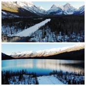
- AIRSTRIP LOCATED INSIDE CHUGACH STATE PARK.
- HIKERS & VEHICLES INVOF AIRSTRIP.
- SHARPLY RISING TERRAIN EAST; SOUTH & WEST QUADRANTS.
- LANDINGS NOT ALLOWED ON LAKE.
- BRUSH UP TO 30 INCHES HIGH ON NE HALF OF RWY, FULL LENGTH.
- RY 14/32 SLOPES DOWN TOWARD LAKE. RY 14 GENTLE HUMP APPROACH END.
Nearby Airports with Instrument Procedures
| ID | Name | Heading / Distance | ||
|---|---|---|---|---|
 |
PAAQ | Warren "Bud" Woods Palmer Municipal Airport | 350° | 15.5 |
 |
PAWS | Wasilla Airport | 311° | 20.9 |
 |
PAED | Elmendorf AFB Airport | 257° | 24.0 |
 |
PAMR | Merrill Field Airport | 252° | 25.7 |
 |
PAGQ | Big Lake Airport | 296° | 26.2 |
 |
PANC | Ted Stevens Anchorage International Airport | 251° | 30.7 |
 |
PAUO | Willow Airport | 309° | 39.1 |
 |
PATK | Talkeetna Airport | 332° | 66.7 |
 |
PAKA | Tatitlek Airport | 111° | 72.9 |
 |
PAWD | Seward Airport | 189° | 73.9 |
 |
PASX | Soldotna Airport | 229° | 79.3 |
 |
PAEN | Kenai Municipal Airport | 235° | 80.3 |


