Login
Register


ACQ
Waseca Municipal/Maynard Richard Stensrud Field Airport
Official FAA Data Effective 2025-12-25 0901Z
Chart Supplement

VFR Chart of KACQ
Sectional Charts at SkyVector.com
IFR Chart of KACQ
Enroute Charts at SkyVector.com
Location Information for KACQ
Coordinates: N44°4.41' / W93°33.18'Located 02 miles W of Waseca, Minnesota on 309 acres of land. View all Airports in Minnesota.
Surveyed Elevation is 1126 feet MSL.
Operations Data
|
|
Airport Communications
| AWOS-3: | 118.425 Tel. 507-835-3657 |
|---|---|
| UNICOM: | 122.800 |
| CTAF: | 122.800 |
| AWOS-3 at OWA (13.0 E): | 128.325 507-455-0642 |
| AWOS-3PT at MKT (18.0 NW): | 118.175 507-625-3726 |
| AWOS-3 at FBL (18.5 NE): | 120.2 507-332-2505 |
- APCH/DEP SVC PRVDD BY MINNEAPOLIS ARTCC ON FREQS 135.0/306.9 (MANKATO RCAG).
Nearby Navigation Aids
|
| ||||||||||||||||||||||||||||||||||||||||||||||||||||||||||||


Runway 15/33
| Dimensions: | 3399 x 75 feet / 1036 x 23 meters | |
|---|---|---|
| Surface: | Asphalt in Good Condition | |
| Weight Limits: | S-12 | |
| Edge Lighting: | Medium Intensity | |
| Runway 15 | Runway 33 | |
| Coordinates: | N44°4.66' / W93°33.35' | N44°4.16' / W93°33.01' |
| Elevation: | 1126.5 | 1119.3 |
| Traffic Pattern: | Left | Left |
| Runway Heading: | 154° True | 334° True |
| Markings: | Non-Precision Instrument in fair condition. | Non-Precision Instrument in fair condition. |
| Glide Slope Indicator | V2L (2.50° Glide Path Angle) | V2L (2.50° Glide Path Angle) |
| Obstacles: | 29 ft Tree 721 ft from runway, 319 ft left of center | |
Services Available
| Fuel: | 100LL (blue) |
|---|---|
| Transient Storage: | Hangars,Tiedowns |
| Airframe Repair: | MAJOR |
| Engine Repair: | MAJOR |
| Bottled Oxygen: | NOT AVAILABLE |
| Bulk Oxygen: | NOT AVAILABLE |
| Other Services: | PILOT INSTRUCTION,PARACHUTE JUMP ACTIVITY,AIRCRAFT SALES,ANNUAL SURVEYING |
Ownership Information
| Ownership: | Publicly owned | |
|---|---|---|
| Owner: | CITY OF WASECA | |
| 508 STATE ST S | ||
| WASECA, MN 56093-3033 | ||
| 507-835-9700 | ||
| Manager: | BRENT LANGER | |
| 508 STATE ST S | ||
| WASECA, MN 56093-3033 | ||
| 507-835-5920 | ||
Other Remarks
- ULTRALIGHT TFC ON & INVOF ARPT.
- FOR CD CTC MINNEAPOLIS ARTCC AT 651-463-5588.
- ACTVT OR INCR INTST VASI RWY 15 & 33; MIRL RWY 15/33 - CTAF. MIRL RWY 15/33 PRESET LOW INTST SS-SR.
Weather Minimums
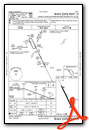
Instrument Approach Procedure (IAP) Charts

Nearby Airports with Instrument Procedures
| ID | Name | Heading / Distance | ||
|---|---|---|---|---|
 |
KOWA | Owatonna Degner Regional Airport | 076° | 13.1 |
|
KMKT | Mankato Regional Airport | 299° | 18.2 |
|
KFBL | Faribault Municipal-Liz Wall Strohfus Field Airport | 033° | 18.5 |
|
KAEL | Albert Lea Municipal Airport | 161° | 24.9 |
|
KTOB | Dodge Center Airport | 095° | 31.4 |
|
KLVN | Airlake Airport | 022° | 36.1 |
|
KAUM | Austin Municipal Airport | 132° | 36.5 |
|
KSBU | Blue Earth Municipal Airport | 219° | 37.0 |
|
KULM | New Ulm Municipal Airport | 290° | 43.5 |
|
KJYG | St James Municipal Airport | 263° | 43.8 |
|
KFRM | Fairmont Municipal Airport | 235° | 45.5 |
|
KFCM | Flying Cloud Airport | 005° | 45.4 |
Airport Images
Do you have a recent image of this airport? Upload it here!


