Login
Register


TOB
Dodge Center Airport
Official FAA Data Effective 2026-01-22 0901Z
Chart Supplement

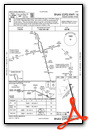
VFR Chart of KTOB
Sectional Charts at SkyVector.com
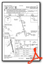
IFR Chart of KTOB
Enroute Charts at SkyVector.com
Location Information for KTOB
Coordinates: N44°1.08' / W92°49.90'Located 01 miles SE of Dodge Center, Minnesota on 165 acres of land. View all Airports in Minnesota.
Surveyed Elevation is 1303 feet MSL.
Operations Data
|
|
Airport Communications
| AWOS-3PT: | 119.075 Tel. 507-374-6369 |
|---|---|
| ROCHESTER APPROACH: | 119.8 251.125 |
| ROCHESTER DEPARTURE: | 119.8 251.125 |
| CTAF: | 122.900 |
| AWOS-3PT at 9MN (15.0 E): | 124.175 507-255-9417 |
| ATIS at RST (15.8 SE): | 120.5 |
| ASOS at RST (16.2 SE): | 507-216-8425 |
- APCH/DEP SVC PRVDD BY MINNEAPOLIS ARTCC ON FREQS 132.35/307.3 (ROCHESTER RCAG) WHEN ROCHESTER APCH CTL CLSD.
Nearby Navigation Aids
|
| ||||||||||||||||||||||||||||||||||||||||||||||||


Runway 16/34
| Dimensions: | 4500 x 75 feet / 1372 x 23 meters | |
|---|---|---|
| Surface: | Concrete in Good Condition | |
| Edge Lighting: | Medium Intensity | |
| Runway 16 | Runway 34 | |
| Coordinates: | N44°1.39' / W92°49.96' | N44°0.67' / W92°49.70' |
| Elevation: | 1298.8 | 1303.7 |
| Runway Heading: | 166° True | 346° True |
| Markings: | Non-Precision Instrument in good condition. | Non-Precision Instrument in good condition. |
| Glide Slope Indicator | P4L (3.00° Glide Path Angle) | P4L (3.00° Glide Path Angle) |
| REIL: | Yes | Yes |
Runway 04/22
NOT PLOWED WINTER MONTHS. | ||
| Dimensions: | 2383 x 200 feet / 726 x 61 meters | |
|---|---|---|
| Surface: | Turf in Good Condition | |
| Runway 04 | Runway 22 | |
| Coordinates: | N44°1.03' / W92°50.21' | N44°1.31' / W92°49.83' |
| Elevation: | 1289.9 | 1294.6 |
| Traffic Pattern: | Left | Left |
| Runway Heading: | 44° True | 224° True |
Services Available
| Fuel: | 100LL (blue), Jet-A |
|---|---|
| Transient Storage: | Hangars,Tiedowns |
| Airframe Repair: | MAJOR |
| Engine Repair: | MAJOR |
| Bottled Oxygen: | NOT AVAILABLE |
| Bulk Oxygen: | NOT AVAILABLE |
| Other Services: | PILOT INSTRUCTION,AIRCRAFT RENTAL,AIRCRAFT SALES |
Ownership Information
| Ownership: | Publicly owned | |
|---|---|---|
| Owner: | CITY OF DODGE CENTER | |
| 23 W MAIN ST, PO BOX 430, PO BOX 430 | ||
| DODGE CENTER, MN 55927-0430 | ||
| 507-374-2575 | ||
| Manager: | WAYNE TROM | |
| 806 AIRPORT DR S | ||
| DODGE CENTER, MN 55927-9173 | ||
| 507-374-6245 | ||
Other Remarks
- WINDMILLS 1.5 NM SW OF ARPT.
- ULTRALIGHT TFC ON & INVOF ARPT.
- FOR CD CTC ROCHESTER APCH AT 507-424-8111.
- ARR/DEP BLDG ACES CODE: 1304.
- YELLOW CONES.
- YELLOW CONES.
- 0LL FUEL AVBL H24 SELF SVC VIA CREDIT CARD.
- ACTVT OR INCR INTST REIL RWY 16 & 34; PAPI RWY 16 & 34; MIRL RWY 16/34 - CTAF. MIRL RWY 16/34 PRESET LOW INTST.
Weather Minimums


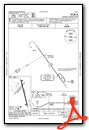
Instrument Approach Procedure (IAP) Charts
Nearby Airports with Instrument Procedures
| ID | Name | Heading / Distance | ||
|---|---|---|---|---|
 |
KRST | Rochester International Airport | 114° | 15.8 |
|
KOWA | Owatonna Degner Regional Airport | 288° | 19.5 |
|
KAUM | Austin Municipal Airport | 191° | 21.8 |
|
KFBL | Faribault Municipal-Liz Wall Strohfus Field Airport | 312° | 27.9 |
|
KAEL | Albert Lea Municipal Airport | 229° | 30.8 |
|
KACQ | Waseca Municipal/Maynard Richard Stensrud Field Airport | 276° | 31.4 |
|
KFKA | Fillmore County Airport | 125° | 34.9 |
|
KRGK | Red Wing Regional Airport | 023° | 37.4 |
|
KLVN | Airlake Airport | 335° | 40.4 |
|
55Y | Rushford Municipal/Robert W Bunke Field Airport | 105° | 45.1 |
|
KMKT | Mankato Regional Airport | 285° | 48.6 |
|
KONA | Winona Municipal/Max Conrad Field Airport | 085° | 48.6 |
Airport Images
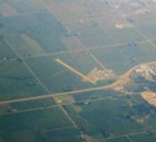
By: Dave


