Login
Register


ADU
Audubon County Airport
Official FAA Data Effective 2026-02-19 0901Z
Chart Supplement

VFR Chart of KADU
Sectional Charts at SkyVector.com
IFR Chart of KADU
Enroute Charts at SkyVector.com
Location Information for KADU
Coordinates: N41°42.09' / W94°55.23'Located 01 miles SE of Audubon, Iowa on 46 acres of land. View all Airports in Iowa.
Surveyed Elevation is 1287 feet MSL.
Operations Data
|
|
Airport Communications
| AWOS-3: | 118.075 Tel. 712-563-2101 |
|---|---|
| CTAF: | 122.800 |
| UNICOM: | 122.800 |
| AWOS-3 at AIO (18.6 S): | 127.825 712-243-2748 |
| AWOS-3 at HNR (19.9 W): | 118.325 712-744-4400 |
| AWOS-3 at CIN (21.5 N): | 118.025 712-792-2306 |
- APCH/DEP SVC PRVDD BY MINNEAPOLIS ARTCC ON FREQS 119.6/290.4. (OMAHA RCAG)
Nearby Navigation Aids
|
| ||||||||||||||||||||||||||||||||||||||||||||||||||||||||||||


Runway 14/32
| Dimensions: | 3641 x 60 feet / 1110 x 18 meters | |
|---|---|---|
| Surface: | Concrete in Good Condition | |
| Weight Limits: | S-15 | |
| Edge Lighting: | Medium Intensity | |
| Runway 14 | Runway 32 | |
| Coordinates: | N41°42.34' / W94°55.44' | N41°41.84' / W94°55.01' |
| Elevation: | 1287.7 | 1277.2 |
| Traffic Pattern: | Left | Left |
| Runway Heading: | 147° True | 327° True |
| Displaced Threshold: | 140 Feet | |
| Markings: | Non-Precision Instrument in fair condition. | Non-Precision Instrument in fair condition. |
| Glide Slope Indicator | P2L (3.00° Glide Path Angle) | P2L (3.25° Glide Path Angle) |
| REIL: | Yes | Yes |
| Obstacles: | 41 ft Tree 1247 ft from runway, 30 ft left of center RWY 14 APCH SLOPE 32:1 TO DSPLCD THLD. |
20 ft Bridge 613 ft from runway, 208 ft left of center |
Services Available
| Fuel: | NONE |
|---|---|
| Transient Storage: | Hangars,Tiedowns |
| Airframe Repair: | NONE |
| Engine Repair: | NONE |
| Bottled Oxygen: | NONE |
| Bulk Oxygen: | NONE |
| Other Services: | CROP DUSTING SERVICES |
Ownership Information
| Ownership: | Publicly owned | |
|---|---|---|
| Owner: | AUDUBON COUNTY ARPT AUTH | LOU HERBERS CHAIRMAN OFFICE# 712-563-4440. |
| P.O. BOX 1 | ||
| AUDUBON, IA 50025 | ||
| (712) 563-4440 | ||
| Manager: | LOU HERBERS | |
| 2110 HIGHWAY 71 | ||
| AUDUBON, IA 50025 | ||
| (712) 563-4440 | ||
Other Remarks
- RY 14 HAS 64 FT LGTD POLE 1200 FT FM THLD 350 FT L.
- FOR CD CTC MINNEAPOLIS ARTCC AT 651-463-5588.
- ACTVT MIRL RY 14/32 AND PAPI & REIL RYS 14 & 32 - CTAF.
- CTAF OTS INDEFLY.
Weather Minimums

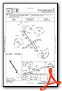
Instrument Approach Procedure (IAP) Charts
Nearby Airports with Instrument Procedures
| ID | Name | Heading / Distance | ||
|---|---|---|---|---|
 |
KAIO | Atlantic Municipal Airport | 197° | 18.8 |
|
KHNR | Harlan Municipal Airport | 249° | 20.1 |
|
KCIN | Arthur N Neu Airport | 015° | 21.5 |
|
KGCT | Guthrie County Regional Airport | 092° | 21.8 |
|
KDNS | Denison Municipal Airport | 309° | 26.8 |
|
KGFZ | Greenfield Municipal Airport | 136° | 31.0 |
|
KEFW | Jefferson Municipal Airport | 054° | 31.9 |
|
KPRO | Perry Municipal Airport | 077° | 35.0 |
|
KSKI | Sac City Municipal Airport | 356° | 40.7 |
|
KCRZ | Corning Municipal Airport | 169° | 43.1 |
|
KRDK | Red Oak Municipal Airport | 200° | 44.2 |
|
3Y3 | Winterset Municipal Airport | 116° | 45.3 |
Airport Images
Do you have a recent image of this airport? Upload it here!


