Login
Register
HLG
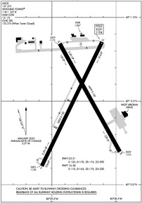
Wheeling Ohio County Airport
Official FAA Data Effective 2026-01-22 0901Z
VFR Chart of KHLG
Sectional Charts at SkyVector.com
IFR Chart of KHLG
Enroute Charts at SkyVector.com
Location Information for KHLG
Coordinates: N40°10.50' / W80°38.78'Located 08 miles NE of Wheeling, West Virginia on 1000 acres of land. View all Airports in West Virginia.
Surveyed Elevation is 1194 feet MSL.
Operations Data
|
|
Airport Communications
| ASOS: | 127.375 Tel. 304-277-3504 |
|---|---|
| WHEELING TOWER: | 118.1 257.8 |
| WHEELING GROUND: | 121.75 |
| PITTSBURGH APPROACH: | 125.275 285.575 |
| PITTSBURGH DEPARTURE: | 125.275 285.575 |
| CLEARANCE DELIVERY: | 125.275 ;WHEN TWR CLSD |
| CTAF: | 118.100 |
| UNICOM: | 122.950 |
| CLASS B: | 119.35 285.575 |
| EMERG: | 121.5 243.0 |
| AWOS-3 at 2G2 (11.7 N): | 121.625 740-275-4862 |
| AWOS-3PT at AFJ (16.5 E): | 119.175 724-228-3529 |
| AWOS-3 at MPG (18.1 S): | 119.05 304-845-2959 |
Nearby Navigation Aids
|
| ||||||||||||||||||||||||||||||||||||||||||||||||||||||||||||
Runway 03/21
| Dimensions: | 5002 x 150 feet / 1525 x 46 meters | |
|---|---|---|
| Surface: | Asphalt / Grooved in Fair Condition | |
| Weight Limits: | S-120, D-170, ST-290 | |
| Edge Lighting: | High Intensity | |
| Runway 03 | Runway 21 | |
| Coordinates: | N40°10.11' / W80°39.08' | N40°10.85' / W80°38.61' |
| Elevation: | 1170.0 | 1194.3 |
| Traffic Pattern: | Left | Left |
| Runway Heading: | 26° True | 206° True |
| Markings: | Precision Instrument in fair condition. | Precision Instrument in fair condition. |
| Glide Slope Indicator | V2L (3.00° Glide Path Angle) UNUSBL BYD 8 DEGS LEFT OF CNTRLN. | |
| RVR Equipment | Touchdown Rollout | Touchdown Rollout |
| Approach Lights: | MALSF 1,400 Foot Medium-intensity Approach Lighting System with sequenced flashers. | |
| REIL: | Yes | |
| Obstacles: | 26 ft Trees 216 ft from runway, 488 ft left of center CTLNG OBSTN EXCEEDS A 45 DEG SLP. 15 FT BRUSH, 0-199 FT DSTC, 370 FT L, 260 FT R. |
10 FT BLDG 150 FT DSTC, 250 FT R; 6 FT FENCE, 0-200 FT DSTC, 0-500 FT L/F; 28 FT TREE, 138 FT DSTC, 408 FT L. |
Runway 16/34
| Dimensions: | 4499 x 150 feet / 1371 x 46 meters | |
|---|---|---|
| Surface: | Asphalt in Fair Condition | |
| Weight Limits: | S-110, D-143, ST-230 | |
| Edge Lighting: | Medium Intensity | |
| Runway 16 | Runway 34 | |
| Coordinates: | N40°10.84' / W80°38.94' | N40°10.20' / W80°38.47' |
| Elevation: | 1171.4 | 1191.0 |
| Traffic Pattern: | Left | Left |
| Runway Heading: | 151° True | 331° True |
| Markings: | Non-Precision Instrument in fair condition. | Non-Precision Instrument in fair condition. |
| Glide Slope Indicator | P4L (3.00° Glide Path Angle) PAPI OTS INDEFLY. | |
| REIL: | Yes | |
| Obstacles: | 17 ft Trees 468 ft from runway, 240 ft right of center | |
Services Available
| Fuel: | 100LL (blue), Jet A+ |
|---|---|
| Transient Storage: | Hangars,Tiedowns |
| Airframe Repair: | NOT AVAILABLE |
| Engine Repair: | NOT AVAILABLE |
| Bottled Oxygen: | NOT AVAILABLE |
| Bulk Oxygen: | NOT AVAILABLE |
Ownership Information
| Ownership: | Publicly owned | |
|---|---|---|
| Owner: | OHIO CO COMSN | |
| 1500 CHAPLINE ST | ||
| WHEELING, WV 26003 | ||
| 304-234-3628 | ||
| Manager: | RUSSEL W. ESCUE | |
| 115 SKYWAY LANE | ||
| WHEELING, WV 26003 | ||
| 304-234-3865 | ||
Other Remarks
- BIRDS AND DEER ON AND INVOF ARPT.
- WHEN ATCT CLSD ACTVT MALSF RWY 03; REIL RWY 21 & 34; PAPI RWY 34; HIRL RWY 03/21; MIRL RWY 16/34; TWY LGTS EXCP TWY A - CTAF.
Weather Minimums
Instrument Approach Procedure (IAP) Charts
Nearby Airports with Instrument Procedures
| ID | Name | Heading / Distance | ||
|---|---|---|---|---|
 |
2G2 | Geary A Bates/Jefferson County Airpark Airport | 347° | 11.4 |
 |
KAFJ | Washington County Airport | 097° | 16.5 |
 |
8G6 | Harrison County Airport | 282° | 17.3 |
 |
KMPG | Marshall County Airport | 193° | 18.1 |
 |
KPIT | Pittsburgh International Airport | 044° | 26.8 |
 |
6G5 | Barnesville/Bradfield Airport | 247° | 27.2 |
 |
KWAY | Greene County Airport | 124° | 28.9 |
 |
G05 | Finleyville Airpark Airport | 081° | 29.6 |
 |
02G | Columbiana County Airport | 000° | 29.9 |
 |
KTSO | Carroll County/Tolson Airport | 319° | 30.5 |
 |
4G5 | Monroe County Airport | 221° | 31.7 |
 |
KAGC | Allegheny County Airport | 071° | 34.7 |


