Login
Register


21D
Lake Elmo Airport
Official FAA Data Effective 2026-02-19 0901Z
Chart Supplement

Airport Diagram

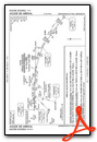
VFR Chart of 21D
Sectional Charts at SkyVector.com
IFR Chart of 21D
Enroute Charts at SkyVector.com
Location Information for 21D
Coordinates: N44°59.83' / W92°51.22'Located 09 miles E of St Paul, Minnesota on 640 acres of land. View all Airports in Minnesota.
Surveyed Elevation is 932 feet MSL.
Operations Data
|
|
Airport Communications
| AWOS-3: | 120.075 Tel. 651-779-5949 |
|---|---|
| MINNEAPOLIS APPROACH: | 121.2 335.65 |
| MINNEAPOLIS DEPARTURE: | 121.2 335.65 |
| CLEARANCE DELIVERY: | 118.625 |
| CTAF: | 123.075 |
| UNICOM: | 123.075 |
| AGUDE STAR: | 335.5 |
| ASOS at STP (9.5 SW): | 118.35 651-312-8888 |
| ATIS at STP (9.5 SW): | 118.35 |
| AWOS-3 at SGS (11.3 SW): | 119.425 651-457-8120 |
Nearby Navigation Aids
|
| ||||||||||||||||||||||||||||||||||||||||||||||||||||||||||||


Runway 14/32
| Dimensions: | 3504 x 75 feet / 1068 x 23 meters | |
|---|---|---|
| Surface: | Asphalt in Good Condition | |
| Weight Limits: | S-11 | |
| Edge Lighting: | Medium Intensity | |
| Runway 14 | Runway 32 | |
| Coordinates: | N44°59.99' / W92°51.48' | N44°59.57' / W92°50.93' |
| Elevation: | 924.8 | 932.4 |
| Traffic Pattern: | Left | Left |
| Runway Heading: | 138° True | 318° True |
| Markings: | Non-Precision Instrument in good condition. | Non-Precision Instrument in good condition. |
| Glide Slope Indicator | P4L (3.50° Glide Path Angle) | P4L (3.50° Glide Path Angle) |
| REIL: | Yes | Yes |
Runway 04/22
| Dimensions: | 2496 x 75 feet / 761 x 23 meters | |
|---|---|---|
| Surface: | Asphalt in Fair Condition | |
| Weight Limits: | S-13 | |
| Runway 04 | Runway 22 | |
| Coordinates: | N44°59.74' / W92°51.42' | N45°0.06' / W92°51.06' |
| Elevation: | 923.7 | 932.7 |
| Traffic Pattern: | Left | Left |
| Runway Heading: | 39° True | 219° True |
| Markings: | Non-Precision Instrument in good condition. | Basic in good condition. |
Services Available
| Fuel: | 100LL (blue), Jet-A |
|---|---|
| Transient Storage: | Hangars,Tiedowns |
| Airframe Repair: | MAJOR |
| Engine Repair: | MAJOR |
| Bottled Oxygen: | NONE |
| Bulk Oxygen: | NONE |
| Other Services: | PILOT INSTRUCTION,AIRCRAFT RENTAL,AIRCRAFT SALES |
Ownership Information
| Ownership: | Publicly owned | |
|---|---|---|
| Owner: | METROPOLITAN AIRPORT CMSN | |
| 6040 28TH AVE A | ||
| MINNEAPOLIS, MN 55450-2799 | ||
| 612-726-8100 | ||
| Manager: | PHILIP TIEDEMAN | |
| 6040 28TH AVE S | ||
| MINNEAPOLIS, MN 55450-2799 | ||
| 763-717-0001 | ||
Other Remarks
- ULTRALIGHT OPS PROHIBITED.
- VOLUNTARY NOISE ABATEMENT PROCS IN EFCT. SEE ARPT WEBSITE FOR MORE INFO.
- DEER, BIRDS, & WILDLIFE ON & INVOF ARPT.
- FOR CD CTC MINNEAPOLIS APCH AT 612-726-9086.
- CALM WND RWY.
- 0LL FUEL AVBL H24 SELF SVC VIA CREDIT CARD.
- ACTVT OR INCR INTST REIL RWY 14 & 32; PAPI RWY 14 & 32; MIRL RWY 14/32 - CTAF. MIRL RWY 14/32 PRESET LOW INTST.
Weather Minimums


Standard Terminal Arrival (STAR) Charts
Instrument Approach Procedure (IAP) Charts


Nearby Airports with Instrument Procedures
| ID | Name | Heading / Distance | ||
|---|---|---|---|---|
 |
KSTP | St Paul Downtown Holman Field Airport | 246° | 9.6 |
|
KSGS | South St Paul Municipal/Richard E Fleming Field Airport | 222° | 11.4 |
|
KRNH | New Richmond Regional Airport | 055° | 16.1 |
|
KMSP | Minneapolis-St Paul International/Wold-Chamberlain Airport | 246° | 17.1 |
|
KANE | Anoka County/Blaine (Janes Field) Airport | 300° | 17.6 |
|
KOEO | L O Simenstad Municipal Airport | 020° | 20.0 |
|
KMIC | Crystal Airport | 280° | 21.6 |
|
KAHH | Amery Municipal Airport | 049° | 26.5 |
|
KLVN | Airlake Airport | 215° | 27.3 |
|
KFCM | Flying Cloud Airport | 248° | 27.7 |
|
KRGK | Red Wing Regional Airport | 147° | 29.1 |
|
3T3 | Boyceville Municipal Airport | 085° | 35.5 |
Airport Images
Do you have a recent image of this airport? Upload it here!


