Login
Register


AIT
Aitkin Municipal/Steve Kurtz Field Airport
Official FAA Data Effective 2026-01-22 0901Z
Chart Supplement

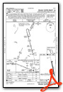
VFR Chart of KAIT
Sectional Charts at SkyVector.com
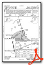
IFR Chart of KAIT
Enroute Charts at SkyVector.com
Location Information for KAIT
Coordinates: N46°32.91' / W93°40.60'Located 02 miles NE of Aitkin, Minnesota on 299 acres of land. View all Airports in Minnesota.
Surveyed Elevation is 1206 feet MSL.
Operations Data
|
|
Airport Communications
| AWOS-3: | 118.675 Tel. 218-927-2101 |
|---|---|
| CTAF: | 123.050 |
| UNICOM: | 123.050 |
| AWOS-3 at HZX (15.7 E): | 119.575 218-768-2593 |
| ASOS at BRD (20.8 SW): | 126.775 218-828-3314 |
| AWOS-3PT at PWC (31.0 W): | 118.525 218-587-3420 |
- APCH/DEP SVC PRVDD BY MINNEAPOLIS ARTCC ON FREQS 118.05/239.0 (BRAINERD RCAG).
Nearby Navigation Aids
|
| ||||||||||||||||||||||||||||||||||||||||||||||||||||||


Runway 16/34
| Dimensions: | 4000 x 75 feet / 1219 x 23 meters | |
|---|---|---|
| Surface: | Asphalt in Fair Condition | |
| Weight Limits: | S-12 | |
| Edge Lighting: | Medium Intensity | |
| Runway 16 | Runway 34 | |
| Coordinates: | N46°33.36' / W93°40.59' | N46°32.72' / W93°40.33' |
| Elevation: | 1205.7 | 1205.9 |
| Traffic Pattern: | Left | Left |
| Runway Heading: | 164° True | 344° True |
| Markings: | Non-Precision Instrument in good condition. | Non-Precision Instrument in good condition. |
| Glide Slope Indicator | P4L (3.00° Glide Path Angle) | P4L (3.00° Glide Path Angle) |
| REIL: | Yes | Yes |
| Obstacles: | 96 ft Tree 1644 ft from runway, 445 ft left of center | |
Runway 08/26
SKI EQUIPPED ACFT ONLY NOV-APR, CALL 218-927-4104 FOR RY CONDS. | ||
| Dimensions: | 3123 x 140 feet / 952 x 43 meters | |
|---|---|---|
| Surface: | Turf in Good Condition | |
| Runway 08 | Runway 26 | |
| Coordinates: | N46°32.72' / W93°41.15' | N46°32.75' / W93°40.40' |
| Elevation: | 1203.5 | 1205.8 |
| Traffic Pattern: | Left | Left |
| Runway Heading: | 87° True | 267° True |
| Displaced Threshold: | 240 Feet | |
| Declared Distances: | TORA:3123 TODA:3123 ASDA:3123 LDA:2883 | |
| Obstacles: | 38 ft Trees 676 ft from runway, 130 ft left of center | 45 ft Trees 819 ft from runway, 64 ft right of center |
Services Available
| Fuel: | 100LL (blue), Jet-A |
|---|---|
| Transient Storage: | Hangars,Tiedowns |
| Airframe Repair: | MAJOR |
| Engine Repair: | MAJOR |
| Bottled Oxygen: | LOW |
| Bulk Oxygen: | NONE |
| Other Services: | AVIONICS,AIRCRAFT SALES |
Ownership Information
| Ownership: | Publicly owned | |
|---|---|---|
| Owner: | COUNTY & CITY OF AITKIN | |
| 109 1ST AVE NW | ||
| AITKIN, MN 56431-1397 | ||
| 218-927-2527 | ||
| Manager: | JENNIFER THOMPSON | |
| 109 1ST AVE NW | ||
| AITKIN, MN 56431-1397 | ||
| 218-927-2527 | ARPT OPS DAY 218-839-1067; NGT 218-851-4502. | |
Other Remarks
- GCO AVBL ON FREQ 121.725 THRU ZMP ARTCC AND PNM FSS.
- FOR CD IF UNA VIA GCO CTC MINNEAPOLIS ARTCC AT 651-463-5588.
- CALM WIND RWY.
- YELLOW CONES.
- YELLOW CONES.
- 0LL 100LL & JET A AVBL H24 VIA CREDIT CARD. FOR SVC CALL 218-839-1067 OR 218-839-6488.
- MIRL RWY 16/34 PRESET LOW INTST; ACTVT OR INCR INTST REIL RWY 16 & 34; PAPI RWY 16 & 34; MIRL RWY 16/34 - CTAF
Weather Minimums


Instrument Approach Procedure (IAP) Charts
Nearby Airports with Instrument Procedures
| ID | Name | Heading / Distance | ||
|---|---|---|---|---|
 |
KHZX | Isedor Iverson Airport | 074° | 15.8 |
|
KBRD | Brainerd Lakes Regional Airport | 245° | 20.8 |
|
KPWC | Pine River Regional Airport | 290° | 31.0 |
|
KXVG | Longville Municipal Airport | 320° | 34.3 |
|
KMZH | Moose Lake Carlton County Airport | 101° | 37.0 |
|
KRYM | Ray S Miller AAF Airport | 226° | 39.5 |
|
KGPZ | Grand Rapids/Itasca County-Gordon Newstrom Field Airport | 009° | 40.3 |
|
KJMR | Mora Municipal Airport | 156° | 42.8 |
|
04W | Field of Dreams Airport | 133° | 45.3 |
|
KLXL | Little Falls/Morrison County-Lindbergh Field Airport | 218° | 45.5 |
|
KSAZ | Staples Municipal Airport | 258° | 47.9 |
|
KCOQ | Cloquet/Carlton County Airport | 078° | 49.4 |
Airport Images
Do you have a recent image of this airport? Upload it here!


